Recent Posts

QGIS 2.6 Released

QGIS is amongst the most featureful open source desktop GIS out there, it just got better this week with the release of QGIS 2.6 ‘Brighton’. The visual changelog offers a long description of the new features and improvements. Here’s the index, please follow the link to read the details and see the accompanying screenshots:

  • General
    • Feature: Project filename in properties
    • Feature: Allow removing last point while measuring via del/backspace keys
    • Feature: select related feature on the canvas from the relation reference widget
    • Feature: Editor widgets
    • Feature: Optionally use just a subset of fields from the joined layer
    • Feature: Expression field (virtual fields)
    • Feature: Actions can now have an associated icon
    • Feature: Additional expressions types and options
    • Feature: Classes within graduated and categorised renderers can be toggled
    • Feature: Legend improvements
  • Data Providers
    • Feature: DXF export improvements
  • Map Composer
    • Feature: Control over hiding print composer items from prints/exports
    • Feature: Control over page printing for empty composer frames
    • Feature: Item tree panel
    • Feature: More control over appearance of composer arrow/line items
    • Feature: Data defined control of composer items
    • Feature: Composer images can be specifed as remote URLS
    • Feature: Composer Table improvements
    • Feature: Composer improvements
    • Feature: Improved item snapping
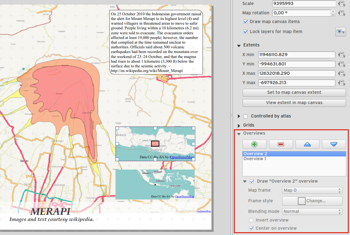
    • Feature: Multiple overviews for a map item
    • Feature: HTML item improvements
    • Feature: Composer map grid improvements
  • Processing
    • Feature: On-line collection of models and scripts
    • Feature: New modeler implementation
  • Programmability
    • Feature: API changes for QGIS widgets
  • QGIS Server
    • Feature: Enhancements of searching with GetFeatureInfo request
    • Feature: Add a precision setting for GetFeatureInfo geometry attributes
  • Symbology
    • Feature: Better random colour choice
    • Feature: Symbology user interface improvements
  • User Interface
    • Feature: Syntax highlighting code editor
    • Feature: Color palettes
    • Feature: New color picker dialog
    • Feature: Single select feature tool merged into select by rectangle
    • Feature: Add layer to map canvas behaviour
    • Feature: Add icon size 48 and 64
    • Feature: New colour buttons
    • Feature: Context menu for identify tool

There’s also other recent QGIS-related entries that are of interest:

  • QGIS Compared: GIS Analysis,comparing hillshading, attribute calculation, generalizing, models and more
  • There’s also a short entry on QGIS Inverse Shapeburst Fills

Screenshot of multiple overviews within a map:

Batch Geonews: Halloween Street View, Cesium 3D Terrains, India’s GNSS, Open Source Dronecode, and much more

Here’s the recent geonews in batch mode.

On the open source / open data front:

  • This is a must see, full instructions to Creating 3D terrains with Cesium
  • Via O’Reilly, I became aware of Google’s open Material Design Icons on GitHub that can certainly be used for maps, reminiscent of the Maki and WorldWeatherSymbols amongst a few
  • New lab, University of Colorado Denver’s FOSS4G Lab
  • Slim OpenLayers, Creating a custom build of OpenLayers 3 (Revisited)
  • Short analysis of the features for creating printable maps, QGIS Compared: Cartography
  • In the same series, QGIS Compared: Visualization
  • Bug fixes and some new features, GeoServer 2.5.3 released
  • Same for GeoTools, GeoTools 11.3 released and GeoTools 12.0 Released
  • Such guides are often useful if it applies to you, A Quick Guide to Getting Started with PyQGIS on Windows
  • Open data in the Netherlands, Unlocking the amazing OpenTopo.nl Maps
  • OpenStreetMap is Making Ayacucho the best map in Latin America

On the Esri front:

  • Esri and open data, All Your Open Data Questions — Answered

On the Google front:

  • Halloween day in Street View! Explore the haunted corners of the world… if you dare
  • New version of Google Earth for Android, Explore the world through Google Earth for Android with fast, accurate maps and here’s a Review of Google Earth for Android Version 8
  • Wired offers an article named Swim Through the Oceans at Your Desk With Google’s 360-Degree Seaview
  • And in the sand too, Roam the Arabian desert with Street View
  • Connecting different sources, No map is an island: Introducing a connected JavaScript Maps API experience
  • With big data everywhere, Mixing maps and WebGL to visualize huge geo datasets
  • If we must, for geo-geeks – new Google’s Earth View extension for Chrome

Discussed over Slashdot:

  • More GNSS options, India Successfully Launches Region-Specific Navigation Satellite
  • Open source and UAVs, Linux Foundation Launches Open Source Dronecode Project
  • Since there will be plenty of driverless cars soon, Michigan Builds Driverless Town For Testing Autonomous Cars
  • A bit more on the topic, What Will It Take To Make Automated Vehicles Legal In the US?
  • Last one on autonomous cars, SMART Begins Live Public Robocar Tests In Singapore
  • Augmented reality becoming a buzzword once again, Google Leads $542m Funding Round For Augmented Reality Wearables Company
  • We already know that privacy is dead, How Whisper Tracks Users Who Don’t Share Their Location
  • There’s always unhappy people, PETA Is Not Happy That Google Used a Camel To Get a Desert “StreetView”
  • Drones salvation, Drones Could 3D-Map Scores of Hectares of Land In Just a Few Hours
  • By mapping phones, Taking the Census, With Cellphones

In the everything else category:

  • We love stats right? The US Mobile App Report – Google Maps App 64.5M Users, Apple Maps 42M
  • Apple’s CarPlay maps? Video Walkthrough of Apple CarPlay on Pioneer Receiver Shows Siri, Phone, Maps, and More
  • Feel like playing? GPS Tycoon – new addictive location-based game for Android
  • We pay you and we know where you are, Government of India Launches Biometric Initiative to Track Public Servants
  • If you’re into Oracle, Oracle Database Cloud Service supports Spatial
  • An upcoming event, Geography, on “multi-year strategic dialog on the vital trends that will reshape our nation and our planet.”
  • On Wired, an article on the tens of remote sensing satellites sent to orbit Huge Flock of Minisatellites Aims to Photograph the Entire Earth Every Day
  • Nice GIS crowdsourced effort Crowdsourcing and Satellites Give Migrating Birds 10K Acres of New Wetlands
  • Fun, using remote sensing, a space detective agency
  • More learning, Introduction to Satellite Navigation & GPS on Coursera

In the maps category:

  • Not an easy place, Mapping Gaza before and after a crisis
  • The history and status of Dubai’s The World islands under construction
  • From Wired, The Greatest Maps in History, Collected in One Fantastic Book
  • From the same source, Super-Detailed Interactive 3-D Seafloor Map
  • An interesting discussion on the weirdness of the Belgium - Germany border
  • An update from GeoCurrrents, My Error on Ukraine’s Political Divisions
  • Passion, Regular Guy From Boston Decides to Map the City’s Entire History

“Introduction to GIS” Course in English free of charge

The gvSIG-Training e-Learning platform opens its registration period for the “Basic GIS with gvSIG” MOOC in English, given by the gvSIG Association and GISMAP.

This MOOC aims to show the use and potentiality of the open source software gvSIG in performing the most common operations during the workflow in a GIS environment. This Course is addressed to beginners as well as to skilled GIS users who want to learn how to use this software.

It will start in November 24th, and it will last four weeks with an approximate participant’s engagement of thirty hours during the whole course period.

Course attendance is completely free of charge. Students who successfully complete the course and wish to receive the Certificate of Achievement, corresponding to 30 credits for gvSIG Certification program, will be asked for a contribution of 40 Euros.

For further information about topics, goals…:

For registration, you have to press “Enroll” at the bottom of the page, and then accept the “Site policy agreement”. Finally you will have to register at the web page.

Weather Maps Across 1,219 US Cities

Weather is a huge factor in not only Where you live, or vacation, but When. Use the 2 interactive maps below and you’ll find:

  • In the top one, the number of days each month that an area is in that sweet spot of 70F to 90F degrees – for over 1,200 US cities, towns and locales.
  • The bottom map tells you the average rainfall and temperatures – all laid out by month - in those same cities.

Get started by just clicking on the State that contains the area you want to know more about in either map. You’ll be amazed what you learn!

Versio: Distributed Version Control for Spatial Data, and GeoGig News (formerly GeoGit)

Spatial data versioning is important to lots of geospatial applications. We mentioned GeoGit (now named GeoGig) quite a few times. This week Boundless announced a private beta (you can request an invitation) of Versio, a website for distributed version control of spatial data.

First, you may want to see how GeoGig (formerly GeoGit) has matured, it’s open source and essentially “[w]ith GeoGig, users are able to import spatial data into a repository where every change to the data is tracked. These changes can be viewed in a history, reverted to older versions, branched in to sandboxed areas, merged back in, and pushed to remote repositories.”

Regarding Versio itself, “With Versio, we want to support as many editing workflows as possible, both online and offline. So we’ve made the platform client-agnostic to support traditional desktop GIS software as well as web, mobile, or custom applications built on the Versio API”.