Here’s the recent geonews in batch mode. On the open source / open data front: That’s fast development, the open source Web GIS Turf 1.4.0 has been released with several new interesting features, if you don’t know Turf, look at it now, it’s part of our geofuture I learned about OpenChargeMap in this discussion named Japan Now Has More Car ...
Read More »Tag Archives: tracking
Batch Geonews: QField, IndoorGML Standard, Focus on Google Maps for Work, 30m SRTM-DEM, and much more
The first batch-mode edition of the geonews. On the open source / open data front: There’s a new free course Introduction to Geospatial Technology Using QGIS (from Feb 23 - Mar 29) which also has content on GitHub Beautiful and simple, How to: watercolor pastel style in QGIS Announced is the FOSS4G-Europe conference, this time in Como, Italy, ...
Read More »Visualize Business Data More Easily - Release of NACMAP Version 5.0
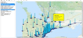
Release of NACMAP Version 5.0 for Business Data Visualization and Mobile Assets Tracking October 21, Toronto, Canada, NAC Geographic Products Inc. announced the release of NACMMAP Version 5.0 - a standalone NAC enhanced business data mapping and real time assets tracking software. The NAC enhanced mapping software can read data directly from online database servers, local database servers, Excel ...
Read More »Apple Geonews: iOS 8 Improves Location Privacy, Indoor Mapping, Transit Directions coming, MapBox GL Introduced, and more
Here’s the recent Apple-related geonews. Welcomed privacy improvements, iOS 8 Strikes an Unexpected Blow Against Location Tracking by randomizing MAC addresses, GeoAwesomeness also shares an entry named Apple’s iOS8 silent war against location tracking On indoor mapping, iOS 8 Tidbits: Randomized MAC Addresses, Safari Credit Card Scanning, Indoor Mapping, and More, James Fee add more, Indoor Positioning with Apple’s M7 ...
Read More »WiTrack: Through-Wall 3D Tracking Using Body Radio Reflections
Happy to all our readers! Yes yes, I'm later than I'd like, but anything geonewsworthy will be shared with you. Thanks for your patience, and you're still welcomed to contribute!
Via O'Reilly, I learned about MIT's WiTrack, used for Through-Wall 3D Tracking Using Body Radio Reflections. You can't do anything to stop being tracked!
O'Reilly summarizes it this way: "Witrack — tracks the 3D motion of a user from the radio signals reflected off her body. It works even if the person is occluded from the WiTrack device or in a different room. WiTrack does not require the user to carry any wireless device, yet its accuracy exceeds current RF localization systems, which require the user to hold a transceiver. It transmits wireless signals whose power is 100 times smaller than Wi-Fi and 1000 times smaller than cellphone transmissions."
They give examples for entire-home gaming, but for elderly monitoring and fall detection too.

Batch Geonews: Remaining Relevant as a GIS Professional, OpenGeo Suite 4.0, 30TB of Imagery in Esri, and much more
Here's the recent geonews in batch mode, covering a too long timespan once again.
On the open source / open data front:
- That's just incredible to see this that snappy in a browser, Dynamic hill shading in the browser
- Open source software can be popular, over 2,500 participants for the Free CartoDB for Beginners Webinar
- Tyler Mitchell offers a new book, Geospatial Power Tools - Open Source GDAL / OGR Command Line Utilities
- With Google Maps API v2 going dark, Upgrading from Google v2 API? Free yourself and upgrade to OpenStreetMap
- Getting speed, Marble Virtual Globe Graduates OSGeo Incubation
- GRASS GIS 7 is still in development, but you can learn about it in News in GRASS GIS 7
- Open source software update, Boundless Releases OpenGeo Suite 4.0
- Another update, GeoTools 10.1 Released
- Impressive what you can quickly do with open source javascript libraries, Showing GPS tracks in 3D with three.js and d3.js
- MapBox, strong contributors to open source geospatial, hired, amongst many others, the creator of Leaflet and Sean Gillies, they also announced MapBox.js v1.4.0
On the Esri front:
- 30TB of fresh data, Latest DigitalGlobe imagery updates span the globe
- ArcGIS development is getting multiplatform, Introducing the ArcGIS Runtime SDK for Qt and updates, Version 10.2 of ArcGIS Runtime SDKs for iOS and OS X are now available and Announcing the ArcGIS Runtime SDK for Android v10.2 release!
On the Google front:
- New versions of Google Earth don't happen every day, Google Earth updated to version 7.1.2.2041, mostly a bugfix release
- New features in Google Maps, including virtual trips in full 3D, From where you are to where you want to go
- Another new tool for recording and sharing stories, Tour Builder: Tell your stories with Google Earth
- Related to the recent international surveillance discussions, Brazil Orders Google To Hand Over Street View Data
- An interesting story, Revisiting the UTA Flight 772 memorial in Google Earth
- As usual, New Google Earth Imagery – November 12
In the everything-else category:
- James is optimistic, Does Ideas4OGC Fix Problems with OGC Standards?, it seems it really helps
- Geoff has a nice summary named James Fee on remaining relevant as a GIS professional
- Not from Google, India gets its own Street View: Wonobo
- While Autonomous Cars Will Save Money and Lives, before more driverless cars, we'll get more driverless trucks, Autonomous Dump Trucks Are Coming To Canada's Oil Sands and why not, UK Town To Get Driverless 'Pods' Mixing With Pedestrians
- Also related, Driverless Cars Are Further Away Than You Think
- What's great is that we're also getting closer to Finland's Algorithm-Driven Public Bus
- In Canada, one of the biggest communications provider is tracking location of all users, no opt-out possible, but it won't be that simple, Is Bell's Plan to Monitor and Profile Canadians Legal?
- In the same vein, Seattle PD Mum On Tracking By Its New Wi-Fi Mesh Network, and you can also Connect To Unsecured Bluetooth Car Systems To Monitor Traffic Flow, I did not know that even car tires have RFID tags that can be tracked
- And we mentioned before being tracked in malls, it gets even more serious with Google Starts Tracking Retail Store Visits On Android and iOS
- Nothing really new there for our regular readers, Police Use James-Bond-Style GPS Bullet, and in the US, Court Rules Probable-Cause Warrant Required For GPS Trackers
- Not the first time we see a similar initiative, Oregon Extends Push To Track, Tax Drivers Per Mile, and this one titled Police Tracking License Plates Nationwide for Massive Data Base of Citizen Car Trips
- There's the usual story on the theme of US Mini-Satellites to Track and Kill Terrorists
- Unsurprisingly, New Job Listings Point to Continued Work on Transit Options in Apple Maps, transit is currently the big absent from Apple Maps, and what might be surprising, Apple Maps Significantly More Popular Than All Other iOS Mapping Apps, Including Google
- VerySpatial shares an entry named The Geography of Twitter
- Two articles on maps and marijuana; Tabulating the Underground Economy, and the DEA’s Pathetic Attempt to Map the Marijuana Trade and Unnecessary Environmental Destruction from Marijuana Cultivation in the United States
- In case you need to know, RapidEye changes name to BlackBridge
- Remote sensing will be more popular than ever, Government and industry to combine for 1150 satellites over next decade (including telecommunications)
In the maps category:
- It has been popular recently, the Digital Attack Map, A Live Map of Ongoing DDoS Attacks
- It happened to Google Maps in, Taiwan Protests Apple Maps That Show Island As Province of China
- In the U.S.? Is there too much arsenic in the soil where you live? Metals, Minerals, Poisons and Maps
- Also for the U.S., Two Detailed Rail Maps and an attempt at Mapping Honesty and Property Crime
- Crime? P relaunches its crime map
- Let's learn a bit more, Get to Know a Projection: Lambert Conformal Conic
- The paper edition is $400, you can get the digital version for $20, The Barrington Atlas Comes to the iPad
- A map of the Countries most vulnerable to climate change
- I'm not certain if we shared that link before or not, the excellent series of 40 maps that explain the world
Londoners Were Tracked By Advertising Firm’s Trash Cans
This story happened during our holiday break earlier this month, but is still interesting to show to which extent we can be geographically tracked without our knowledge. The Slashdot story went this way: Londoners Tracked By Advertising Firm's Trash Cans.
Their summary: "Hundreds of thousands of pedestrians walking past 12 locations unknowingly had the unique MAC address of their smartphones recorded by Renew London. Data including the "movement, type, direction, and speed of unique devices" was recorded from smartphones that had their Wi-Fi on. First reported by Quartz, the data gathering appears to be a Minority Report-esque proof-of-concept project, demonstrating the possibility for targeted personal advertising. 'It provides an unparalleled insight into the past behavior of unique devices — entry/exit points, dwell times, places of work, places of interest, and affinity to other devices — and should provide a compelling reach data base for predictive analytics (likely places to eat, drink, personal habits etc.),' reads a blog post on the company's site. In tests running between 21-24 May and 2-9 June, over 4 million events were captured, with over 530,000 unique devices captured. Further testing is taking place at sites including Liverpool Street Station." (The name sounds a bit like a government project, but Renew London is actually an advertising / marketing firm.)
Quickly enough, the followup story was London Bans Recycling Bins That Track Phones.
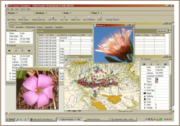
Read More »CyberTracker: Free GPS Field Data Collection System
With the launch of their Android version, I became aware of CyberTracker, a free "GPS Field Data Collection System that turns your smartphone into a sophisticated tracking and monitoring device". It's a non-profit organization and they mention free software several times, but not certain that is open source software, anyone knows?
![]()
From the website: "You can use CyberTracker on a Smartphone or handheld computer to record any type of observation. CyberTracker, which requires no programming skills, allows you to customize an Application for your own data collection needs. [...] CyberTracker is the most efficient way to gather large quantities of geo-referenced data for field observations at a speed and level of detail not possible before. Observations can be entered with a simple Radio List or a Check List. Number and text fields can also be entered by means of conventional key pads or keyboards."
Plenty of screenshots here and the list of features.
Batch Geonews: New Google Maps App, 3D Printing in Windows 8.1, GeoServer Enterprise, MapBox Real-time Satellite Imagery, and much more
Here's the geonews in batch mode. Some of them may have deserved their own entry.
On the open source / open data front:
- OpenLayers 2.13.1 has been released, but arguably more exciting is OpenLayers 3.0 - alpha.2, they're getting closer
- W3C is Launching the Open Data Directory
- Introducing GeoServer Enterprise, it's GeoServer with long term support releases and more
- Here's the FOSS4G-CEE Bucharest, Romania final thoughts
- Montreal's public transport organization adopted OpenStreetMap for their maps, another example of how mature enough OSM has become
- Nokia uses the open source CartoDB to show off traffic data
- Good news, California Supreme Court Says GIS Data are Public Data
On the Esri front:
- It was the Esri User Conference this week, you can read Geoff's 3D and other themes of this year's conference entry
- Jack Dangermond explaining How Esri Hit $912 Million in Sales, very interesting, including: "One thing that has made us so successful is that we've never taken outside investment. That means we can concentrate on what our customers want--not what the stockholders or the VCs want. That's a strategic advantage."
- You'll find a lot lot more on the Esri blog for the International User Conference
- New imagery for Esri tools, DigitalGlobe and community imagery added to the World Imagery map
- ArcGIS Online just got more advantageous, Get More with ArcGIS Online – Announcing Subscription Savings
On the Google front:
- Google announced their new Google Maps app for smartphones and tablets
- Also over Slashdot, Google Updates Maps, Makes First Stable Chrome Release Using WebKit Fork
- Rest reassured, the iOS Enhanced Google Maps App with iPad Support 'Coming Soon'
- Unsurprisingly, there was New Google Earth Imagery – July 8
Geo-related news discussed over Slashdot:
- Microsoft Reveals Its 3D Printing Strategy For Windows 8.1
- 3 GLONASS-M GNSS satellites destroyed, Russian Rocket Proton-M Crashes At Launch
- MapBox is aiming at nothing less than Real Time Imagery via MapBox Satellite Live
- But that's clearly the beginning, read APB's entry named Real-Time Data is Really Here ... Kind of, Almost
- Again, City-Sized Ice Shelf Breaks Free Of Antarctica
- New Zealand ISP Offers "Global Mode" So Users Can Circumvent Geo-Restrictions
- Something we discussed before, Automated Plate Readers Let Police Collect Millions of Records On Drivers
- UCSD Lecturer Releases Geotagging Application For "Dangerous Guns and Owners"
In the miscellaneous category:
- Interesting, O'Reilly shares news about Sifted, a 7-minutes animation set in a cloud points world, geo-geeky
- A Newly Published Apple Mapping Patent Details Route Feedback System, Real-Time Accident Reporting
- O'Reilly mentions Cricket, an indoor location system from MIT, but the latest news appear to be from
- If you're into Minecraft, you'll like Hangouts with James Fee:: Professional Minecraft GIS
- Here's starting points regarding Cross Platform Development with Bing Maps and PhoneGap
- In the U.S., Round-the-clock GPS tracking of state worker ‘unreasonable’ (via SL)
In the maps category:
- A series of maps on Who Serves in the U.S. Military? Mapping Enlisted Troops and Officers
- Here's Midtown Manhattan Growth Animation (1850-2015) and Toronto Growth Animation (1834-2013) and San Francisco Growth Animation (1877-2015) and Calgary Growth Animation (1892-2016)
- Now available, a New global ESA Vegetation Map
LibanPost Adopts Global Postal Code System
 |
June 18, Toronto, Canada, NAC Geographic Products Inc. announced that LibanPost - the postal service provider of Lebanon has licensed Global Postal Code System (also called Universal Address System) to establish a nation-wide address database and provide Global Postal Code based postal services in Lebanon. Before knowing the Universal Address, Mr. Khalil Daoud, Chairman and Managing Director of LibanPost, had worked with public committees for over 10 years to establish an address system in Lebanon without success. Lebanese residents continue using "landmark"-based references to identify the location of their homes, such as “beside the hospital”, “in front of the school”. Postal services rely on locals to deliver mail to households based on somewhat arbitrary knowledge about who lives where. |
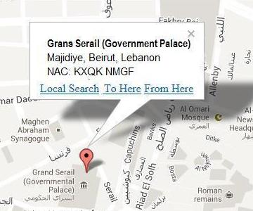
The introduction of the Universal Address will vastly change the situation. Generated from longitude/latitude coordinates, a Universal Address i.e. an eight or ten character Natural Area Code (NAC) can uniquely specify a house, building or even a fire hydrant anywhere in the world, and can be obtained with a smartphone or an online high resolution satellite image map such as NAC Locator. For example, the Universal Address of Grand Serail is NAC: KXQK NMGG and Lighthouse NAC: KXN7 NMH0. With the Universal Addresses, you can get the turn by turn driving directions from Grand Serail to Lighthouse immediately with NMGG&daddr=KXN7 NMH0.
Unlike conventional addresses, the Universal Address does not need people to assign and is readily available for public use for all location purposes. If it is printed on an evelope of a letter, LibanPost will be able to sort the letter from the world level to final household mailboxes automatically and deliver it right to your home efficiently. In an emergency situation, a given Universal Address can significantly accelerate emergency address dispatching and locating. If you tell the Universal Address to your visitor, he can use a GPS navigation system to get to your home without your directions. Governments can use Universal Addresses to register properties and collect property taxes. Banks and insurance companies can use Universal Addresses to verify the home locations of their clients.
"The adoption of the Universal Address will hopefully solve all Lebanese addressing problems," said Dr. Xinhang Shen, president of NAC Geographic Products Inc., "and it is also another milestone toward the unification of postal code systems in the world."
About NAC Geographic Products Inc.
Incorporated in 1995 in Toronto, Canada, NAC Geographic Products Inc. is a world's leading company in geographic technologies and geo-services, developing GIS/GPS software products and providing APIs for real-time geo-services (geocoding addresses, reverse-geocoding, mapping, routing, etc.) for web applications and wireless location based services, etc.