Here’s the last batch-mode edition, covering most of December. Might interest some of you, Slashgeo’s posts are now mirrored on Google+. Have an excellent holiday break. On the open source / open data front: More support for the standard, GDAL GeoPackage raster support Reading, The Book of OpenLayers 3, completed And another one announced, 2nd edition ...
Read More »Tag Archives: privacy
Batch Geonews: OL3-Cesium Library, Embed Street Views, OGC Web Coverage Tile Service, and much more
Here’s the recent geonews in batch mode. On the open source / open data front: The new OL3-Cesium library, integrating OpenLayers 3 and Cesium together for smooth switching between 2D and 3D A new book on the open source GDAL/OGR library, “Geospatial Power Tools” by Tyler Mitchell Not directly geospatial but for 3D, Tao3D: a New Open-Source Programming Language For ...
Read More »Batch Geonews: OpenStreetMap Contributions, QGIS Cloud, Google ‘The Cartographer’, O’Reilly Book, and much more
Here’s the latest geonews in batch mode. On the open source / open data front: Ready for FOSS4G, the geospatial open source software collection named OSGeo-Live 8.0 has been released Pictures tell you everything, OpenStreetMap contributions around the world Informative charts, The OpenStreetMap Contributor Activity Report – Edition We mentioned QGIS Cloud two years ago, here’s an entry ...
Read More »Batch Geonews: Amazon Fire 3D Phone, Esri’s GeoPlanner, New MOOCs, 60-80% of all data is geo, 40cm Imagery, and much more
Completing the catching up of all the geonews for June. From the Esri front: Esri is Introducing GeoPlanner for ArcGIS “a new premium web app focused on meeting the needs of planning and design professionals across a wide range of industries” GeoAwesomeness discusses ESRI’s new GIS MOOC: Going Places with Spatial Analysis There’s New Landscape layers on ArcGIS Online and ...
Read More »Apple Geonews: iOS 8 Improves Location Privacy, Indoor Mapping, Transit Directions coming, MapBox GL Introduced, and more
Here’s the recent Apple-related geonews. Welcomed privacy improvements, iOS 8 Strikes an Unexpected Blow Against Location Tracking by randomizing MAC addresses, GeoAwesomeness also shares an entry named Apple’s iOS8 silent war against location tracking On indoor mapping, iOS 8 Tidbits: Randomized MAC Addresses, Safari Credit Card Scanning, Indoor Mapping, and More, James Fee add more, Indoor Positioning with Apple’s M7 ...
Read More »Batch Geonews: Get Your Google Glass on April 15, TopoJSON, GDAL/OGR for ArcGIS, Ukraine Maps, and much more
Here's the recent geonews in batch mode.
On the open source / open data front:
- Here's AmigoCloud's open source GDAL/OGR plugin for ArcGIS
- I learned about dat, an open source 'data management package' with revision control, with similarities (competing with?) with GeoGit, related, GeoGit for Python: Announcing geogit-py
- We already told you about GeoJSON over GitHub, but you can go further with GitSpatial, a spatial API for GitHub-hosted GeoJSON files
- MySQL trying to catch up PostGIS, MySQL 5.7 GIS building on Boost Geometry
- GeoA shares an entry on StoryMap JS: Tell your own story using the Open-Source Story Map tool
- Amongst recent software updates, MapTiler 0.5.3
- More editing ahead, 500,000 km2 Satellite Imagery Update for OpenStreetMap Tracing, meanwhile you can do it yourself; Drone Adventures Imagery for Tracing in OpenStreetMap: Fukushima + Lima
On the Esri front:
- 'Explorer for ArcGIS', yes, that's for this month on iOS, Explorer for ArcGIS is coming!
- Interoperability, Using OpenLayers to work with REST and OGC services from ArcGIS Server
- 2TB of new imagery, New DigitalGlobe content released in World Imagery basemap
- Updated, ArcGIS API for JavaScript Version 3.9 Released
- Becoming open, Esri ArcGIS Open Data Update
On the Google front:
- That's it, anyone in the U.S. can finally buy their own Google Glasses, but if you want one, you need to buy it on Tuesday April 15 or wait until it becomes really available to everyone, anytime, Anyone Can Buy Google Glass April 15 and directly over CNN, Google Glass available to anyone for one day only - and yes, quantities are limited
- A generic and informative article About Google Earth Imagery
- With the data layer, Build a map infographic with Google Maps & JavaScript
- Maps everywhere, USGS Maps in Google Maps Gallery
- Angkor Wat, Wander through Angkor’s thousand-year-old temples on Street View
- Another article on The obscured areas of Google Earth
Discussed over Slashdot:
- Thanks open licenses, New York Public Library Releases Over 20,000 Hi-Res Maps
- Another way to do 3D viz, 3D Display Uses Misted Water
- Taxi sharing, Taxis By Algorithm: Streamlining City Transport With Graph Theory
- Still possible in, Russian GLONASS Down For 12 Hours
- Crowdsourced traffic app, In Israel, Class-Action Plaintiff Requests Waze Source Code Under GPL
- Location privacy once again, London's Public Bike Data Can Tell Everyone Where You've Been
- A map of submarine cables, Oxford Internet Institute Creates Internet "Tube" Map
- Another kind of map, Physicists Produce Antineutrino Map of the World
- Thanks OpenStreetMap once again, Racing To Contain Ebola, the map on MapBox: Mapping an entire city in a day
In the everything else category:
- We never specifically addressed the TopoJSON format, which is topological GeoJSON, related, GeoJSON for linked data, The GeoJSON-LD project
- A post that clearly demonstrates why GML was never a good solution: GML madness, hope GeoPackage will be a better one
- We never really mentioned the Internet of Things yet, worth reading a bit about this current buzz word since it has obvious geolocation ties, related, The Internet of Things forecasted to include 26 billion intelligent devices by
- Another informative entry on what is geofencing, Geofencing And My Business
- An why not, Cloak – location-based anti-social app lets you avoid annoying friends and exes
- A Make article on DIY Satellites: Now and Near Future and another one named Your Own Satellite: 7 Things to Know Before You Go
- Here's why remote sensing is a profession, Earth observation data and revenue generation; the catch and guidelines and it's evolving fast, Earth observation satellite startups set to transform the EO imaging ecosystem
- Corporate privacy is dead too, monitor Saudi Arabia oil reserves from satellites, Monitoring Oil reserves from Space
In the maps category:
- GeoCurrents offers a series over Ukraine, Ukrainian Regionalism and the Federal Option, Energy Issues in the Ukrainian Crisis and Russian Envelopment? Ukraine’s Geopolitical Complexities, also related, How cartographers should map Crimea?
- In the UK? UK Air Pollution Forecast Map
- Maps is money, The interactive map of taxi trips in New York city
- And a map of companies and their worldwide presence OpenCorporates Maps by KILN
- Fiction maps, The Secrets and Clues of the Official Game of Thrones Maps and why not, The Geology of 'Game of Thrones'
Batch Geonews: GeoPackage Webinar, Esri and Open Data, Future of Google Earth, OpenLayers 3 News, QGIS 2.2, and much more
Here's the recent geonews in batch mode. I've been struggling with many fires, I currently publish much less frequently than usual, but don't worry, everything major is in there!
From the open source / open data front:
- Dubbed as the Shapefile replacement, we discussed the GeoPackage standard several times, next week March 5 there's a webinar about it
- Certainly useful, GitHub adds visual history for maps, visualizing geojson updates directly on a map
- In case you missed the press release, open source 3D city platform ViziCities released on GitHub
- The power of open data, At Sochi Olympics, Crowdsourced OpenStreetMap Trounces Google Maps
- And if you wonder, Sochi was not mapped for Olympics and look at the nice maps you can do with open data - Sochi, with love
- News of OpenLayers 3 currently in beta 2, OpenLayers 3 Is Coming, Creating a custom build of OpenLayers 3 and there's even The book of OpenLayers3 is coming
- Using MapServer on Windows? Announcing MapServer MapManager 1.0
- In other updates, what's new in QGIS 2.2 which by itself could have deserved it's own entry, GeoTools 10.5 released and Rasterio 0.6
- Interesting entry on PostGIS bugs
From the Esri front:
- An article from readwrite, Esri Enables Federal Agencies To Open GIS Mapping Data To The Public
- We mentioned it last November, Introducing Esri’s Geotrigger Service: Welcome to the Future of Geofencing
- There's CityEngine key new features
- And What’s coming in ArcGIS Online March
- APB also offer Top 10 Take-Aways from the Opening Plenary of Esri’s Federal GIS Conference
From the Google front:
- Here's a very interesting article from Frank Taylor on the future of Google Earth, which apparently is being left aside in favor of Google Maps
- Google is Introducing Google Maps Gallery: Unlocking the World’s Maps
- The Canadian north in Street View, Wandering in the footsteps of the polar bear with Google Maps
- And it goes to India too, Discover the Taj Mahal and other iconic Indian monuments on Street View
- And a frequent topic, Monitoring the World's Forests with Global Forest Watch
- And if you don't like OpenStreetMap and open data, Expanding Google's Map Maker community in Southern and Eastern Europe
- A book review, Google Maps JavaScript API Cookbook
- Pretty nice and useful, Visualizing Google Search Results overlaid over 3D buildings
Discussed over Slashdot:
- DIY, Radar Expert Explains How To Cheaply Add Radar To Your Own Hardware Projects
- Video, not just photo anymore, New 360-Degree Video Capture Method Unveiled
- After autonomous cars, Terrafugia Wants Their Flying Car To Be Autonomous
- Don't tell me you're surprised, Lumia Phones Leaking Private Data To Microsoft
- That's not fun for their users, Major Vulnerability In Tinder Dating App Allowed User [ Location ] Tracking
- Cellphone tracking, Death By Metadata: The NSA's Secret Role In the US Drone Strike Program
- And some of the time there's hope, ICE License-Plate Tracking Plan Withdrawn Amid Outcry About Privacy
- And there's the good uses, A New Use For Drones: Traffic Scouting
- Not surprising, Australian Police Deploy 3D Crime Scene Scanner
- A New Interactive Map For Understanding Global Flood Risks and here's a related article
- It's not going well for our oceans, 3D Maps Reveal a Lead-Laced Ocean
- It's actually from DigitalGlobe, Google Earth's New Satellites
- Car navigation, Dead Reckoning For Your Car Eliminates GPS Dead Zones
- And cars will chat together, Government To Require Vehicle-to-vehicle Communication
In the everything-else category:
- Interested in Lidar? Read LIDAR Format Wars: Towards an Open Future and it matters, Report predicts that low cost LiDAR will be disruptive in next 5 years, also related, LiDAR Data Quality Standards, Certification Discussed at LiDAR Forum Session
- Here's a list of Free GIS Apps on the Google Play Store
- Earlier this month, the 'father of GIS, Roger Tomlinson, passed away
- It has been a while since we discussed The State of CAD and GIS Integration
- A new article on What Skills Does A GIS Analyst Require
- An anniversary this month, Celebrating 25 Years of Not Getting Lost Thanks to GPS
- Groups on Earth Observations? What is GEO
- Microsoft, 15 New 3D Cities Available in the Bing Maps Preview App
- Law, California Appeals Court Rules State Law Doesn't Prohibit Driver Use of Smartphone Maps
- VIa OR, Mapping Twitter Topic Networks: From Polarized Crowds to Community Clusters
- Via OR, after iBeacons and many others, here's the Nokia Treasure Tag
- OGC news, OGC Activities and Mobile Industry Trends and the Candidate OGC IndoorGML standard available for public comment
- Amazing what you can do for fantasy locations, If Middle-Earth Were Real, These Exquisite Shots Would Be Its Vacation Brochure
- Here's a fake mapped town that became real, Agloe, the Paper Town Stronger than Fiction
- New online courses, New Geo MOOC: From GPS and Google Maps to Spatial Computing
In the maps category:
- Over Canadian national news website, there was a mention of the map of legal cannabis in the U.S.
- Syria over Wired, Hyperlocal Neighborhood Maps Reveal the Chaos in Aleppo
- Nice map, A Map of U.S. Intercity Bus and Train Routes
- The First online Global Freshwater Biodiversity Atlas
And thanks to Andrew Zolnai for his recent donation to Slashgeo, we wouldn't be there without the community!
Read More »Batch Geonews: Sochi Olympics, Esri Maps for SAP, All Cars Tracked by, and much much more
Here's the recent geonews in batch mode. I don't aggregate geonews as frequently as I used to but the content is there and I hope to return to an increased frequency later this Winter. Are you German? If so, you might be interested in these efforts to have Slashgeo translated in German.
On the open source / open data front:
- The 20 millionth edit in OpenStreetMap, entry that includes some interesting stats such as 1.5 million registered users and 2,17 billion nodes in the database
- Yes, the FOSS4G-CEE is now transformed in a recurrent FOSS4G-Europe conference
- The City of Montreal's textured 3D buildings are now freely available in CityGML
- Some releases, GeoServer 2.4.4 Released, Rasterio 0.5, GeoTools 10.4 Released
- Good news, Brazil's open data and open source satellite monitoring system dramatically reduces illegal deforestation in the Amazon
- From MapBox, new interactive heatmaps plugin, they also shared their beautiful woodcut-inspired map for the entire world, MapBox also gets Customizable maps in Tableau
- It's coming Odyssey.js to "help journalists, bloggers, and other people on the web publish stories that combine narratives with maps and map interactions" (via APB)
On the Esri front:
- From Esri's blog, 10 open source projects every JavaScript geo dev should know about
- SAP being pretty common in the enterprise, Esri Maps for SAP BusinessObjects released!
On the Google front:
- From the official source, Introducing Slovenia Street View and updating Russian imagery
- And of course, Mapping the Sochi Winter Olympics in Google Earth
- They can do that too, How Google identifies house numbers in Street View
- Interesting on WebGL and more, 4 reasons why Google’s Lego-Maps is not your average tech demo
- I haven't seen the movie yet, Every Earth view from “Gravity” identified in Google Earth
- Mountain lover? Awesome Google Earth image of Mount Everest from NASA
- And why not, Snowboarding in Google Earth
Discussed over Slashdot:
- In the U.S.? Map of Publicly-Funded Creationism Teaching
- Locating workers all the time, Virtual Boss Keeps Workers On a Short Leash
- Privacy once again, EU Secretly Plans To Put a Back Door In Every Car By
- Location leaks via Angry Birds and Google Maps, NSA and GCHQ Target "Leaky" Phone Apps To Scoop User Data
- Using Android and care about your privacy? The App That Tracks Who's Tracking You
- Crowdsourcing located tweets, Rome Police Use Twitter To Battle Illegal Parking
- Thanks open data, Open Data Tells NYC Residents Where the Rats Are
- Another indication that 3D printing is getting mainstream, Dell Partners With MakerBot To Resell 3D Printers and Scanners and World's First Multi-Color, Multi-Polymer 3D Printer Unveiled
- History meets digital, Atlas of US Historical Geography Digitized
- Impressive hack, Finnish Hacker Isolates Helicopter GPS Coordinates From YouTube Video Sounds
- Satellite for near real-time measurements of global rain and snowfall
- Mapping outer worlds, First Global Map Outside the Solar System
- You were certainly convinced already, Why We Need OpenStreetMap (Video)
- We knew about that already, Mozilla Is Mapping Cell Towers and WiFi Access Points
In the miscellaneous category:
- Nice, France To Make Older Spot Images Available to Researchers for Free
- It's easy to agree with, Why Leaders Should Learn Geography
- A new initiative GI-N2K, Geographic Information: Need to Know, towards a more demand-driven geospatial workforce education system
- Convincing, LiDAR pushes archaeological revolution
- Location-driven music, Ryan Holladay: To hear this music you have to be there. Literally
- Build your own GPS, no kidding, over Make: Finding Your Way with GPS
- Stilll from Make, Using Quadcopters for Photogrammetry
- Nothing surprising there, How geolocation may play a bigger role in future newsgathering
- Wired on There’s a Science to Foot Traffic, and It Can Help Us Design Better Cities
- Also from Wired, How the U.S. Maps the World’s Most Disputed Territories
- GPS accuracy: GAGAN, India's SBAS (similar to WAAS) is now operational
In the maps category:
- Ok, that's strange / map geeky. Vend they fir jug 45679: the Map Hiding Under Your Fingers
- As always, Brian Timoney is pretty pertinent, In Praise of the Static Map
- A map of scientific research, The Research Map of the World
- Informative, The Last 40 Years Of The World’s Refugees On A Single Map
- And scary, If all the Ice melted: National Geographic’s Interactive map on Rising Seas
Batch Geonews: Predictions, Near Real-Time Imagery of Earth, Location Privacy, LiDAR Formats, and much more
The first batch geonews edition!
On the open source / open data front:
- An informative update on the OGR OpenFileGDB driver to read Esri's file geodatabase format
- Plugin to display QGIS 2D maps in 3D in a web browser via three.js
- Interesting predictions and trends, Juan Marin’s Predictions for and Paul Ramsey’s Predictions for and MapBrief Geo Predictions
- We never mentioned the open source data portal software before, but it supports geospatial data pretty well
- Via OR, MapGive — U.S. State Dept launches OpenStreetMap contributing tool “to help humanitarian efforts”, and the State of the Map will be held in Buenos Aires
- Some software updates, MapGuide Maestro 5.1, Geopaparazzi 3.9.0 is out, SAGA 2.1.1 released, Mapbox.js v1.6.0
- Using open source software to answer Will the sun shine on us?
- Talking of the sun, News from Marble: Introducing Sun and the Moon and Planets
On the Google front:
- Really worth taking a look to Climate Viewer 3D: The Google Earth Climate Change, Pollution and Privacy Viewer
- A new book, Google Maps JavaScript API CookBook
- Viewing the Topography of the Thermohaline Circulation of the Oceans in Google Earth
- There's New 3D imagery in Tokyo and other Japanese cities
- From Slashdot. Google Removes "Search Nearby" Function From Updated Google Maps
- Why not, Creating artwork based on Street View
- If genealogy is within your interests, Genealogy through Google Earth
On the Apple front:
- Description of an Apple Maps App with Interactive Data Layers Detailed in New Patent
- Will this concept catch up? Apple's iBeacon Technology Brings New Possibilities for Location-Based Gaming
- Nokia's HERE not popular enough? Nokia Pulls 'HERE' Maps App for iOS, Citing iOS 7 Changes That 'Harm the User Experience'
Discussed over Slashdot:
- Yes, this is coming, Swarms of Small Satellites Set To Deliver Close To Real-Time Imagery of Earth another related entry is named Planet Labs to capture near-continuous whole-Earth imagery from 28 five kilogram satellites
- If you're a regular Slashgeo reader, you know this already, Why the World Needs OpenStreetMap, and it's time to migrate 'en masse' according to The Guardian
- On privacy, It's Not Just the NSA: Police Are Tracking Your Car
- But you know what? Carmakers Keep Data On Drivers' Locations From Navigation Systems
- And here's a confirmation, Ford Exec: 'We Know Everyone Who Breaks the Law' Thanks To Our GPS In Your Car
- But there's always hope? Recent Federal Trade Commission (FTC) Settlement Will Make It Harder to Collect and Share Geoinformation In US
- First step before commercial drones, Feds Announce Test Sites For Drone Aircraft
- For fun, CES: Building Self-Guiding Lego Robots for Fun and (Maybe) Profit (Video)
- There are still wonders to discover, thanks to geo, Lasers Unearth Lost 'Agropolis' of New England
- Tracking bees, Scientists Glue Sensors To 5,000 Bees In a Bid To Better Understand Them
In the everything else category:
- A geodesy dream? Affordable Arduino-Compatible Centimeter-Level GPS Accuracy
- Using LIDAR data? Read Format Wars Episode V: LIDAR, why? Esri Launches its Own Propriety Compressed LiDAR Format: .zlas
- An article on Spike, creating 3D models of buildings and things with a smartphone, not the first app of that kind but that one comes from a GIS company
- Free map online course from Coursera to begin in April
- You already know what IFTTT recipes are? Here's you'll learn about geoenabling triggers with geofences and more
- Here's about SenseFly, a drone for taking oblique imagery
- A generic entry on the Cocktail of Technologies for Smart Cities: The role of Geospatial Tech
- Wired on Tracking the Secret Lives of Great White Sharks
- Let's talk about our privacy again, DARPA’s 1.8 gigapixel ARGUS-IS: The Ultimate Surveillance System from above?, that's 1.8 gigapixels and 12 frames/second, 24/7
- On the SPOT remote sensing satellite family, up to SPOT 7, The new SPOTs
- On 3D printing, yup, really mainstream now, Adobe Adds 3D Printer Support To Photoshop and here's about the open source ' slic3r ' — converts a digital 3D model into printing instructions for your 3D printer (via OR)
In the maps category:
- On mapmaking, The Hidden Meanings of Maps: Design and Colors
- Beautiful, A woodcut inspired map for city streets
- Jonathan provides a book Review: A History of the World in Twelve Maps
- And here's A look at twelve maps that changed the world
- Don't we all like beautiful maps? Wired shares The Most Amazing, Beautiful and Viral Maps of Year
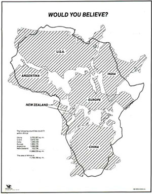
- Here's a map you have to see, would you believe how big is Africa? Mercator projections are messing with our perception of the world
Batch Geonews: 25m European DEM, OpenLayers 3 vs Google Maps API v3, GeoMedecine, and much much more
Here what's probably our latest geonews in batch mode entry, have a nice holiday break!
From the open source / open data front:
- Boundless published a OpenLayers 3 & Google Maps API Compared
- Python and raster data? Introducing rasterio
- Here's an entry on the 25m European Digital Elevation Model (EU-DEM, Version 1)
- Much more efficient, OpenStreetMap's Redesign Goes Live! More Focused, More Inviting, More Map, and still on OSM data, Disability Mapping with OpenStreetMap
- In updates, GeoTools 10.3 Released and GeoServer 2.4.3 Released and MapGuide Open Source 2.5.2 and MapBox.js v1.5.0
- Beautiful, Using the 25m EU-DEM for shading OpenStreetMap layers
From the Esri front:
- A summary of What’s New in ArcGIS Online (December)
- Still breathing, ArcGIS 3.6 for Flex Released
From the Google front:
- Having kids? Join Santa and his elves in the countdown to Christmas Eve
- An entry telling you how to Create your own Street View
- The Bing Maps architect Blaise Aguera y Arcas is joining Google
- Google is improving maps in Building Better Maps in Brazil, Israel, and Russia
- You might be interested by National Geographic shares rich map content with the world via Google Maps Engine
- There's the classic, New Google Earth Imagery – December 6
In the everything-else category:
- If you haven't heard of the GeoPackage draft standard yet, read this, OGC's Geopackage standard enables geospatial data sharing for mobile devices
- Things do change, Open Geospatial Consortium updates its vision, mission, policies and procedures
- A new Eye in the Sky, First Images form Skybox’s SkySat-1 Released
- An interesting read about How Can Geography Literacy Be So Bad At The Age Of Google Earth?
- Wired shares an entry named 6 Reasons to Get Over Your Fear of Coding and Start Making Better Maps
- The rise of GeoMedecine? A 10-minutes TED talk about named Your health depends on where you live
-
Apple geo-related news:
-
Geofencing to Unlock Vehicle Functions Detailed in New Apple Patent Application
-
iBeacon Technology Tapped to Unlock Location-Specific Newsstand Content on iOS Devices and Apple Updates Apple Store App with Support for iBeacon Systems, but Apple is far from being alone in that race, Qualcomm Launches 'Gimbal' Bluetooth LE iBeacon Competitor
-
-
If you're not already convinced autonomous cars going to happen;
- Ford Self-Driving R&D Car Tells Small Animal From Paper Bag At 200 Ft.
-
Nissan Leaf Prototype Becomes First Autonomous Car On Japanese Highways
-
Volvo Plans To Have Self-Driving Cars In Swedish City of Gothenburg By
-
Geo and privacy:
- If there was doubts, NSA Tracking Cellphone Locations Worldwide
- An extreme scenario, Meet Jack, or What The Government Could Do With All That Location Data
- But there are watchdogs? FTC Drops the Hammer On Maker of Location-Sharing Flashlight App
- and hope, Boston Police Stop Scanning Registration Plates, For Now
- but it's really everyone, Indiana State Police Acknowledge Use of Cell Phone Tracking Device
- and sometimes it's good, New GPS Tracking Bullet May Render High-Speed Police Chases Obsolete
- Not that surprising, Need Directions? Might Not Want To Ask a Transit Rider
- We heard lots about drones, now it's time for SkyJack, a hacking system taking control of drones and the discussion on the topic, How To Hijack a Drone For $400 In Less Than an Hour - talking of Drones, that's impressive Drone Footage of Bangkok Protests
- In Canada? The new Canadian Geodetic Vertical Datum of (CGVD2013) recently launched
- Reality surpasses fiction once again, New MIT Camera Takes 3D Photos in the Dark
- You see, geospatial is evenin our heads! Memories Are ‘Geotagged’ With Spatial Information, Penn Researchers Say
- Underwater, First 3D topography of Great Barrier Reef derived from EO data
- A discussion about National GIS for India
In the maps category:
- Wired shares Some of the Year’s Best Images of Earth From Space, nice indeed
- Income distribution across the US, Census Bureau: Majority of Affluent Counties In Northeast US
- Here's a long review fo the Barrington Atlas iPad App
- Bitcoin? Coinmap – The Interactive Map Of Brick And Mortar Locations Accepting Bitcoins
- Wow, take a look at The “underwater waterfall” of Mauritius Island