The popular open source web mapping library OpenLayers 3.5.0 has been released. Some of the new features according to the official blog: “Among the features in this release is a new snapping interaction. This can be used in conjunction with the draw and modify interactions to allow vector editing with snapping support. See the new snap example for a demonstration ...
Read More »Tag Archives: web mapping
CubeWerx signs 3-year contract to provide managed imagery services to the the Saskatchewan Geospatial Imagery Collaborative
Gatineau, QC, Canada, April 14 – CubeWerx signs 3-year contract to provide managed imagery services to the the Saskatchewan Geospatial Imagery Collaborative CubeWerx has signed a 3-year contract with the Saskatchewan Geospatial Imagery Collaborative (SGIC) to provide imagery hosting and managed Web services to the collaborative’s many member organizations across the province and in the federal government. The contract, signed ...
Read More »OpenLayers 3.4.0 Released
The popular open source web mapping library OpenLayers version 3.4.0 has been released today. Some new features according to the announcement: “Dateline wrapping has been added for tile sources, you can most clearly see this in the new wms-tiled-wrap-180 example. The draw interaction can now draw circles as well, check out the updated draw features example and select Geometry type Circle. […] ...
Read More »Turf: New Open Source WebGIS
We begin year with pretty interesting and major news. WebGIS is one giant step closer to be seriously useful, thanks to the new open source WebGIS project named Turf. From the MapBox announcement: “Turf is GIS for web maps. It’s a fast, compact, and open-source JavaScript library that implements the most common geospatial operations: buffering, contouring, triangular irregular networks ...
Read More »Getmapping Imagery added to Grant Thornton’s Flagship Mapping Application
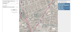
Getmapping’s nationwide aerial imagery is now available to users of Grant Thornton’s Place Insight web based mapping application. This online research and intelligence service provides exceptional ground detail and reduces the need for site visits. Adding imagery was a simple task thanks to Getmapping’s simple-to-use ‘API’ and modern WMS/WFS internet protocols. Grant Thornton’s Place Insight suite of web-based analytics ...
Read More »GeoServer 2.6.0 Released
One of the popular geospatial data server just got an update, GeoServer 2.6.0 has been released. Here’s an exhaustive list of talks on GeoServer at FOSS4G. The new features, according to the announcement: WFS Cascade: WFS Cascade has been updated to use a brand new GeoTools wfs client implementation. Curve support for GML and WMS: GeoServer curve support has ...
Read More »OpenLayers 3.0 Released
This is major news. The open source OpenLayers library is one of the most widely used web mapping software. After a complete overhaul of the venerable 2.x branch, OpenLayers 3.0 has been released. From the announcement: “This release includes a ton of new features such as an easier to use API as well as improved vector rendering and image manipulation. […] ...
Read More »Cesium 3D Web Mapping Library 1.0 Released
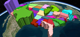
Cesium is an open-source JavaScript library for creating 3D and 2D web maps. It uses WebGL for hardware-accelerated graphics. Version 1.0 includes support for worldwide high-resolution terrain; global imagery from standards such as WMS, OpenStreetMap, Bing Maps, and ArcGIS MapServer; vector data from GeoJSON and TopoJSON; 3D models using glTF; and a large geometry library.
Read More »Testing web map APIs - Google vs OpenLayers vs Leaflet
Geospatial technologies evolve quickly, here's a fresh comparison of web mapping API and libraries, Testing web map APIs - Google vs OpenLayers vs Leaflet.
From the conclusion: "Google, for example, can easily insert adverts into its maps without us knowing. Leaflet and OpenLayers, being open source, cannot. That said, if your aim is just to get attractive 'off the shelf' maps up quickly, Google Maps is a good option. OpenLayers is mature and big and works well with servers. Leaflet, as the new kid on the block is the most exciting for me and encapsulates many of the benefits of open source software in general: speed of development, flexibility, efficiency. [...] Lightness considered, for me that would mean Leaflet for many applications, but watch this space for the final version of OpenLayers3 (due very soon) and perhaps even better web mapping options."
Read More »GeoServer 2.5 Released
GeoServer is one of the most popular web mapping / web services server, and it just got to version 2.5.
The key features according to the announcement:
- WCS 2.0 and WCS 2.0 Earth Observation have been added
- The addition of a batch importer to making setting up GeoServer easier
- High performance PNG encoder based on PNGJ library (Andrea Aime). Improved JPEG performance using libjpegturbo available as an optional extension
- Use of ST_Simplify to improve PostGIS rendering performance
- New implementation of GetFeatureInfo that takes into account symbol shapes, offsets, and dynamic line widths into account