Thanks to Between the Poles I learned about the new SpringerOpen journal named ‘Open Geospatial Data, Software and Standards’. Its content is published under a Creative Commons license (CC-BY). The aims and scope: “Open Geospatial Data, Software and Standards provides an advanced forum for the science and technology of open data, crowdsourced information, and sensor web through the publication of reviews ...
Read More »Tag Archives: open data
Batch Geonews: Landsat-live and on AWS, OpenStreetMap Reaches 2M Contributors, Vector Tiles, and much more
Here’s the recent geonews in batch mode. Slashgeo has recently been a victim of a hack and was hosting some ‘commercial’ links on a hidden sub-site — nothing users would have found out unless they were directed to this parallel site by a third-party. We addressed the issue and, while it never directly impacted the Slashgeo you’re used to, I’m ...
Read More »OpenStreetMap Gets Routing on its Main Website
It has been possible to get driving directions from OpenStreetMap data for quite a while, but what’s new and major is the capability to get directions directly from OpenStreetMap, meaning more competition to Google Maps and similar services. This is also discussed over Slashdot. From the announcement: “Well, the first thing to note is that the philosophy of OpenStreetMap is not ...
Read More »Q&A with OpenStreetMap’s Founder Steve Coast
In December we mentioned the now-successful crowdfunding initiative for The Book of OpenStreetMap, to be written by Steve Coast, the founder of OpenStreetMap. During the Holiday Break, Steve Coast participated to a live reddit “Ask Me Anything” session on OpenStreetMap, and there’s a lot of pretty interesting discussion in there. And Steve did answer my own question Here’s some snippets: ...
Read More »Slashgeo is a proud media partner of FOSS4G-Asia
We are happy to inform you that Slashgeo will be a proud media partner of the upcoming Free & Open Source Solutions for GIS (FOSS4G) - Asia conference held in Bangkok, Thailand, 2-5 December! FOSS4G-Asia aims to bring together FOSS4G users and developers worldwide and foster closer interactions with and amongst Asian communities in order to ...
Read More »Huellasolar launches its OpenPlatform, an online environment to build radiation and sun exposure maps of cities and projects.
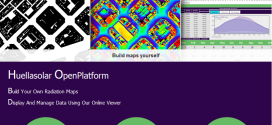
Huellasolar opens its system and offers tools to be used for designers, companies, institutions, architects, engineers, students etc. along the world to build radiation maps of their cities or projects. Generated maps are displayed and shared online thorugh a specifically designed viewer including a lot of features to analyze and get data from the model Monthly and hourly radiation and ...
Read More »Open Source / Data Geonews: the 10 Years of OpenStreetMap adn Related News, WebGL Earth 2, and much more
Still catching up the geonews that showed up during our holiday break, here’s the open source / open data geonews in batch mode. Open source geospatial software: Desktop virtual globes on their way out? Here’s WebGL Earth 2, “Open-source virtual planet web application running in any web browser with support for WebGL HTML5 standard” There’s Geocolor that we haven’t mentioned ...
Read More »Continuing to make our data open: The LINZ Data Service (LDS) now supports OGC GeoPackage
Land Information New Zealand’s Data Service now supports the Open Geospatial Consortium (OCG) GeoPackage format for file downloads. The LINZ Data Service (LDS) is a world-leading open data service providing free and open access to New Zealand government-held geodetic, hydrographic, cadastral, topographic and place name data. LDS Manager Jeremy Palmer says the release of OCG GeoPackage on the service comes ...
Read More »The OpenCage Geocoder Enters Public Beta
If you were at State of the Map EU recently, you might have seen the OpenCage Data team launch a new, open data driven, geocoding API. If you weren’t then you might like to know that the OpenCage Geocoder is now publicly available in beta. Powered by OSM data and a whole lot more and wrapping other open source geocoders, ...
Read More »Handy Maps Social and Routing
Bloggage update: After posting stripped French electorate data in my Cambridgeshire UK postcode area to help canvassing with my mobile from free arcgis, I added some geoprocessiong on my freemium ArcGIS Online account:
-
Update 1: see the social map created from this on a custom arcgis account
- Update 2: see the traveling salesman problem executed on this simple example
Do let me know what you think of this! This is my first try, and I reported a few issues on time awareness and service area calculations, so stay tuned.... I keep using all means available, to learn web mapping and to share it with you.
Read More »