Weather is a huge factor in not only Where you live, or vacation, but When. Use the 2 interactive maps below and you’ll find: In the top one, the number of days each month that an area is in that sweet spot of 70F to 90F degrees – for over 1,200 US cities, towns and locales. The bottom map tells ...
Read More »Tag Archives: United States
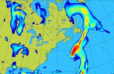
United States and Canada Weather Radar Mosaic Now Available in WMS and KML
[since the weather radar mosaic has been proven very popular, I felt it deserved it's own announcement]
Part of the sister announcement of the global and regional weather prediction layers, in GeoMet services, there's also the popular weather radar North-American mosaic. It covers United States and Canada in a single layer available in WMS and KML. The data is refreshed every 10 minutes and can be easily animated via the KML file. Here's the link to the WMS GetCapabilities and the KML file for Google Earth. For Esri users, here's the ArcGIS Online map with the layers. Interested in staying in touch with the improvements to GeoMet, join the announce mailing list. (Disclaimer: I am personally involved with GeoMet)
According to the WMS GetCapabilities, the weather radar mosaic is provided as 4 different layers:
- RADAR_RDBR: Rain mode reflectivity (dbz)
- RADAR_RDBS: Snow mode reflectivity (mm/hr)
- RADAR_RRAI: Rain precipitation (mm/hr)
- RADAR_RSNO: Snow precipitation (cm/hr)
From the documentation page: "Meteorological layers are dynamically served through the Web Map Service (WMS) standard to enable end-users to display meteorological data within their own tools and on interactive web maps, and served through KML standard for easy display in tools such as Google Earth™. [...] This service is aimed at specialized users and developers with good meteorological and information technology knowledge who want to visualize raw NWP models and the weather radar mosaic layers in common geospatial tools; want to integrate meteorological layers into their own platforms, or; want to display meteorological layers on interactive web maps for the web or on mobile devices."
Those interested in the U.S.-only weather radar layer in WMS and WCS described as "Mosaic of National Weather Services RADAR for CONUS 1x1 Km resolution" can head on this NOAA website. The following image provided by Environment Canada comes from the GeoMet services but that's not the weather radar mosaic layer.
Batch Geonews: Google Earth 7.1 Released, OpenSnowMap, OpenPOIs, MapBox.js 1.0, and much more
Here's the recent geonews in batch mode.
On the open source front:
- Both Leaflet and MapBox are current hot topics, today you get both in the same announcement: Announcing MapBox.js 1.0 with Leaflet
- With open data, there's no limit to new services... here's OpenSnowMap, leveraging OpenStreetMap and MODIS snow cover data (via OGD)
- GeoTools 9.1 has been released
- And GeoServer 2.3.1 too
- Here's the open source OSCAR-js javascript map API, which "extends OpenLayers and uses popular UI libraries (jQuery UI and YUI)"
- The FOSS4G CEE conference completed their Keynote Speakers lineup
On the Google front:
- The GEB informs us that Google Earth 7.1 has been released, with enhancements mostly for the Google Earth Pro 7.1 version
- Google is Celebrating the 50th country on Street View, with Hungary and Lesotho being the latest additions, with expansions in Poland and Romania
- For those interested, The Boston Marathon Manhunt in Google Earth
- If you prefer Ice Hockey, here's The world of Hockey in Google Earth
- Canadian Public Alerts are now included in Google Now, Google Search and Google Maps
In the everything-else category:
- Here's the U.S. New Strategy for Earth Observations, directly from the White House: "The new Strategy outlines a process for evaluating and prioritizing Earth-observation investments according to their value to society in critical areas such as agriculture, global change, disasters, water resources, and weather."
- The Spatial Law blog offers a summary on Privacy of geolocation: the new European and American law
- Indications that Facebook and Google Would Like Apple to Feature Them More Prominently on iOS
- An interesting entry on crisis cartography
- Discussed over Slashdot, Should California Have Banned Checking Smartphone Maps While Driving?
- Also discussed by the same site, Why Local Is So Damn Hard For Startups: Foursquare Borrows $41M To Try Again
- On standards, interesting read the consequences of the GeoJSON 1.0 axis order policy (via James)
- Also on standards, in this OGC blog entry, you'll learn about the efforts related OGC OpenPOIs Registry: "A database of points of interest information containing names and point locations for millions of businesses and civic places across the globe"
- The GEB tells us about the new Geo3D Market website, a place to buy and sell 3D models
- APB informs us that Microsoft Updates Maps App in Windows 8
- From the same source, a definition of geoblocking: "Geoblocking is the system used to limit your access to the internet, based on your geographic location."
In the maps category:
- APB links to a Greenpeace Map of the Arctic, nicely wrapped I must admit
- In Vietnam, you may get a 2,400$ fine for National Map violations
- A New chart shows the entire topography of the Antarctic seafloor in detail for the first time
- Via APB, an article named Can quality of life be mapped?
First City In the US To Pass an Anti-Drone Resolution
Drones are a great way to do cheap remote sensing, but regulations are becoming more severe, Slashdot discusses a story named First City In the US To Pass an Anti-Drone Resolution.
Their summary: "According to an Al-Jazeera report, 'Charlottesville, Virginia is the first city in the United States to pass an anti-drone resolution. The writing of the resolution coincides with a leaked memo outlining the legal case for drone strikes on U.S. citizens [on foreign soil] and a Federal Aviation Administration plan to allow the deployment of some 30,000 domestic drones.' The finalized resolution is fairly weak, but it's a start. There is also some anti-drone legislation in the Oregon state Senate, and it has much bigger teeth. It defines public airspace as anything above your shoelaces, and the wording for 'drone' is broad enough to include RC helicopters and the like."
Read More »Batch Geonews: JS.geo, Instant StreetView, 3D Printing, Drones, Autodesk in the Cloud, and more
Here's the recent geonews in batch mode.
From the Esri front:
- An interesting entry on Designing the next generation of online Topographic Maps
- There's an ArcGIS Online World Topographic Map New Design which includes High-resolution imagery for South America, Australia, New Zealand, and Afghanistan
- The Esri U.S. Demographic Data Release
On the web maps front:
- We mentioned it before, and here's more details on JS.geo: A Meeting of Javascript Mappers in Denver
- There's a new site to give you Instant Google Street View (direct link)... worth trying, it's really fast
- Also Google-related, the GEB talks about GPS4Sport that combines GPS with Video and Google Earth
-
On Apple Maps
- Rumors of OS X 10.9 to Include Siri and Maps Integration
- A lot of geoblogs mentioned that Apple axed the head of its mapping team, Richard Williamson (more here)
- Microsoft added New Imagery Added to Windows 8 Maps App & Bing Maps
- The MapBox iOS SDK hits version 0.5.0
- Two weeks ago, TomTom launched its SDK for LBS Apps, including maps, geocoding, routing, traffic
In the miscellaneous category:
- Launched less than 10 days ago, MarineRegions, "towards a global standard of georeferenced marine names" (via Kurt)
- A slashdot story named French Company Building a Mobile Internet Just For Things
- While 3D printing have most of its applications outside of geospatial, I found interesting that it's really going mainstream as demonstrated by Staples To Offer 3D Printing Services, an O'Reilly story named Printing ourselves, the state of 3D Printing Patent Suits (via OR), and yes, you can 3D-print your own drone
-
More news about drones:
- The Make magazine offers a gift guide for aerial drones (via OR)
- But beware, High Levels of Burnout in US Drone Pilots (via OR)
- VerySpatial offers an entry on Forensic GIS and the Role of Geospatial Technologies for Investigating Crime and Providing Evidence
- Apparently, there's Nokia offline maps available in Firefox OS (alpha)
-
If you're excited by OGC standards
- There's the development of an international standard for 4D archaeological data
- And soon, Augmented Reality Standard ARML 2.0 in its Final Stage
- If you're in the U.S., you'll be interested by the GAO Report on Federal Geospatial Data Coordination
- You wonder about earth observation satellites from Russia? Here's news about the Resurs-P with 3-m hyperspectral capabilities and other Russian satellites
- As part of Autodesk University, you'll find the Autodesk CEO saying “I do believe that everything is moving to the cloud.” and an entry indicating that Autodesk's future is in the cloud
In the maps category:
- Interesting maps, U.S. Geography of Personality: The United States of Mind
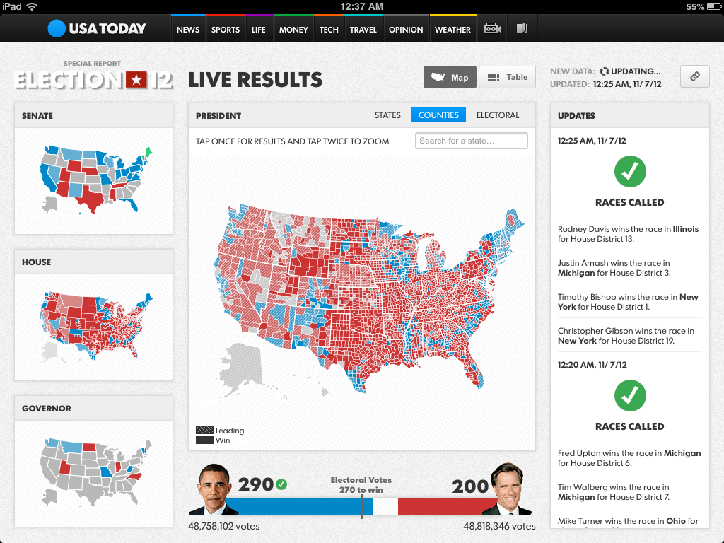
U.S. Election Maps Wrap Up
Interactive U.S. election maps were unsurprisingly everywhere. Here's some of them and related content.
- Interesting analysis comes from GeoCurrents, in a set of videos on the geography of U.S. presidential elections, and also in an informative entry named Preliminary Observations on the U.S. Presidential Election
- MapBox explains how they built USA TODAY's Election Night Maps (example below)
- The GEB provide links and allows you to quickly compare CNN, Huffington Post and Google elections maps
- The New York Times has their own set of interactive maps, and so does CNN
- VerySpatial links to a Smithsonian article named When Republicans Were Blue and Democrats Were Red
U.S. In Danger of Losing Earth-Observing Satellite Capability
That's the name of the Slashdot story, U.S. In Danger of Losing Earth-Observing Satellite Capability.
Their summary: "As reported in Wired, a recent National Research Council report indicates a growing concern for NASA, the NOAA, and USGS. While there are currently 22 Earth-observing satellites in orbit, this number is expected to drop to as low as six by the year. The U.S. relies on this network of satellites for weather forecasting, climate change data, and important geologic and oceanographic information. As with most things space and NASA these days, the root cause is funding cuts. The program to maintain this network was funded at $2 billion as recently as, but has since been scaled back to a current funding level of $1.3 billion, with only two replacement satellites having definite launch dates."
Read More »U.S. NHTSA Suggestion Would Cripple In-Car GPS Displays
Slashdot is discussing a story named NHTSA Suggestion Would Cripple In-Car GPS Displays.
Their summary: "The recently issued National Highway Transportation Safety Agency guidelines for automakers to minimize distraction for in-vehicle electronics included a proposal to freeze maps on navigation systems. No more scrolling maps... just static pictures. 'Every current installed navigation system uses the car as a fixed point, and shows the map moving around it. NHTSA wants that changed so as to keep the map fixed. Even showing the position of the car moving on the map could be considered a dynamic image. The recommendation seems to suggest that the position of the car could only be updated every couple of seconds. Likewise, the map could be refreshed once the car has left the currently displayed area. This recommendation would essentially make navigation unusable. The system could still give an auditory warning for the next turn, but without being able to glance down at the map and see how close the next street is would likely lead to a lot of missed turns and resultant frustration.'"
Read More »After US v. Jones, FBI Turns Off 3,000 GPS Tracking Devices
Two days ago, Slashdot discussed a story named After US v. Jones, FBI Turns Off 3,000 GPS Tracking Devices.
Their summary: "The Supreme Court's recent ruling overturning the warrantless use of GPS tracking devices has caused a 'sea change' inside the U.S. Justice Department, according to FBI General Counsel Andrew Weissmann. Mr. Weissmann, speaking at a University of San Francisco conference called 'Big Brother in the 21st Century' on Friday, said that the court ruling prompted the FBI to turn off about 3,000 GPS tracking devices that were in use. These devices were often stuck underneath cars to track the movements of the car owners. In U.S. v. Jones, the Supreme Court ruled that using a device to track a car owner without a search warrant violated the law. After the ruling, the FBI had a problem collecting the devices that it had turned off, Mr. Weissmann said. In some cases, he said, the FBI sought court orders to obtain permission to turn the devices on briefly – only in order to locate and retrieve them."
Will this mean less GPS tracking stories in the future?
Read More »Commercial Drones Taking To the Skies in the U.S.
During the weekend, Slashdot discussed the stiry named Commercial Drones Taking To the Skies. And the reason why I'm sharing it is the inevitable impacts of ubiquitous commercial UAVs will have on remote sensing.
Their summary: "A new federal law, signed by the president on Tuesday, compels the Federal Aviation Administration to allow drones to be used for all sorts of commercial endeavors — from selling real estate and dusting crops, to monitoring oil spills and wildlife, even shooting Hollywood films. Local police and emergency services will also be freer to send up their own drones. But while businesses, and drone manufacturers especially, are celebrating the opening of the skies to these unmanned aerial vehicles, the law raises new worries about how much detail the drones will capture about lives down below — and what will be done with that information. Safety concerns like midair collisions and property damage on the ground are also an issue."
Read More »