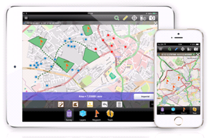
ThinkGeo Releases Map Suite for Android, iOS and WebAPI November 20, Frisco, TX — ThinkGeo is proud to announce the additions of Map Suite WebAPI , Map Suite for Android and iOS platforms to the Map Suite family of products. These new editions rounds out the full-line of offerings available from the Map Suite GIS software components for developers. ThinkGeo’s Map Suite for Android and iOS ...
Read More »Tag Archives: iOS
Apple Geonews: iOS 8 Improves Location Privacy, Indoor Mapping, Transit Directions coming, MapBox GL Introduced, and more
Here’s the recent Apple-related geonews. Welcomed privacy improvements, iOS 8 Strikes an Unexpected Blow Against Location Tracking by randomizing MAC addresses, GeoAwesomeness also shares an entry named Apple’s iOS8 silent war against location tracking On indoor mapping, iOS 8 Tidbits: Randomized MAC Addresses, Safari Credit Card Scanning, Indoor Mapping, and More, James Fee add more, Indoor Positioning with Apple’s M7 ...
Read More »Fulcrum Adds Real-Time Data Publishing Features
Many of Fulcrum’s users are in the field collecting data which later needs to be shared with various stakeholders, like clients, government agencies, or management team members. We recently released a feature that makes this process even easier. Data Shares allow you to generate simple URLs for downloading or accessing data within your Fulcrum Apps that you can publish or share.
Now, all users with Small plans and above have Data Shares available. An account’s owner can enable sharing for a specific App, and then have access to a URL that serves up that data in a variety of formats: CSV, KML, GeoJSON, or JSON. The owner can then give the link to, for example, a client. Each time the client accesses the link, they’ll pull up-to-date data from that App.
Being able to access your App’s data easily in multiple formats allows for sophisticated uses of that information in real-time.
Why This is Powerful
Data collection efforts are often continuous, with teams out in the field on a daily basis conducting inspections, user surveys, or field reports hour by hour, and syncing them to the cloud where the information can be visualized or exported. Many users export data as CSV on a recurring basis to analyze or merge with other data on their own systems. Now, once a data share has been enabled, you’ll be able to have their script use the URL to automatically fetch fresh data without running an export.
It’s powerful to visualize the data you collect, especially to quickly convey progress to stakeholders. Now it’s much easier to build a web map that uses current data each time the map is refreshed. You can use something like Bootleaf and a GeoJSON data share to easily display the data you’ve collected on a map. There are many parameters that can be used to customize the data returned to give a lot of flexibility and control.
Other users may have used the Google Earth Streaming capability to quickly visualize the data they collect. But that shows data from all your Apps. Using a KML data share will allow this same, quick visualization scoped to just the App you want to share.
Using QGIS, the free and open source GIS software, you can even use a GeoJSON data share URL and add your live data to a QGIS map project using the data share URL. This is fantastic for getting a mappable layer into a GIS for combining with your other GIS data layers.
We hope these examples give you an idea of what else you can do with Data Shares and how valuable they’ll be to your efforts to use your data once collected.
About Fulcrum
Fulcrum is a mobile data collection platform built to allow users to design custom field survey form templates to deploy to mobile staff on iOS and Android devices. Fulcrum has been helping organizations with mobile field staff save time and money, and collect better GIS information. Read more about Fulcrum by visiting the website, or follow us on Twitter or Facebook for updates.
Read More »Comsoft Paris Uses SuperSurv 3 to Extend Enterprise Solutions
Supergeo Technologies, the leading global provider of complete GIS software and solutions, announced that Comsoft Paris selected SuperSurv, the data collection app for Android and iOS platforms, to extend business solutions and service ranges.
Collaborating with Géo.RM, Supergeo reseller in France, Comsoft has more than 23 years experience in providing professional software counseling. The products range widely from top designers of diverse domains, including antivirus, drawing, compiler, backup, which could be largely applied to health care, education, business, and other fields. The software expert selects SuperSurv to strengthen their provision.
SuperSurv 3 is the professional surveying application suitable for Android and iOS powered devices. With supreme geospatial data collection functions, users are able to efficiently gather needed information, and timely share accurate data with SuperGIS Desktop and SuperGIS Server for more applications.
As the leading GIS software, SuperGIS series products are utilized comprehensively in different countries and various application domains, to support professionals in daily GIS tasks. The success application by Comsoft could not only extend European markets for Supergeo, but also spread GIS software from geospatial industry to general business uses.
# # #
About Supergeo
Supergeo Technologies Inc. is a leading global provider of GIS software and solutions. Since the establishment, Supergeo has been dedicated to providing state-of-the-art geospatial technologies and comprehensive services for customers around the world. It is our vision to help users utilize geospatial technologies to create a better world.
Supergeo software and applications have been spread over the world to be the backbone of the world’s mapping and spatial analysis. Supergeo is the professional GIS vendor, providing GIS-related users with complete GIS solutions for desktop, mobile, server, and Internet platforms.
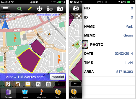
Read More »iOS-Powered SuperSurv 3.2 Now Available to Simplify Field Data Collection
Supergeo Technologies, a leading global provider of complete GIS software and solutions, announced that the latest iOS-powered SuperSurv 3.2 is officially released to bring powerful GIS functions for streamlining field data collection for Apple devices users.
Designed for field survey with iPad and iPhone, SuperSurv 3.2 for iOS supports offline editing, attribute query, tracklog recording and display, adding Waypoint, and Augmented Reality. The whole new mobile GIS app integrates with GIS and GPS technologies to perform Map Display, Query, Measure, etc, and support point, line and polygon data.
SuperSurv 3.2 for iOS also allows users to employ OpenStreepMap as the basemap to collect feature data including attribute data, and save the data in SHP and GEO formats. Besides, the Customized Attribute Table is offered to effectively cluster attribute data. Data like collected layer files and GPS tracklog can be exported through iTunes and utilized in various GIS programs.
# # #
About Supergeo
Supergeo Technologies Inc. is a leading global provider of GIS software and solutions. Since the establishment, Supergeo has been dedicated to providing state-of-the-art geospatial technologies and comprehensive services for customers around the world. It is our vision to help users utilize geospatial technologies to create a better world.
Supergeo software and applications have been spread over the world to be the backbone of the world’s mapping and spatial analysis. Supergeo is the professional GIS vendor, providing GIS-related users with complete GIS solutions for desktop, mobile, server, and Internet platforms.
Read More »Supergeo Renews Partnership Agreement with Géo.RM in France
Supergeo Technologies, a leading global provider of complete GIS software and solutions, announced to extend partnership with Géo.RM to cooperatively promote SuperGIS software and solutions in French-speaking countries. This collaboration would encourage greater use of SuperGIS software and solutions in France and further break into new markets in Europe.
Established in 1991 and based in Poitiers, France, Géo.RM is the professional system integrator which specializes in offering custom GPS and GIS mapping solutions, and the consulting service to fulfill the growing needs of field mapping.
In addition to reasonable prices, SuperGIS mobile GIS software such as the newest SuperSurv and SuperPad support iOS, Android, and Windows Mobile powered devices, helping users develop flexible GIS applications to improve field operations, increase accuracy of data collection, and therefore assist organizations with better decision-making.
Through extending partnership with Géo.RM, it allows Supergeo to promote SuperGIS solutions to French-speaking users. Supergeo commits to continuous product innovations and service improvement in order to support Géo.RM in finding and even creating new business opportunities.
# # #
About Supergeo
Supergeo Technologies Inc. is a leading global provider of GIS software and solutions. Since the establishment, Supergeo has dedicated to providing state-of-the-art geospatial technologies and comprehensive services for customers around the world. It is our vision to help users utilize geospatial technologies to create a better world.
Supergeo software and applications have been spread over the world to be the backbone of the world’s mapping and spatial analysis. Supergeo is the professional GIS vendor, providing GIS-related users with complete GIS solutions for desktop, mobile, server, and Internet platforms.
Supergeo is looking for business partners worldwide like UK and Germany.
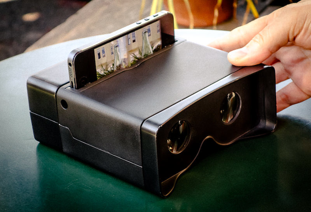
Read More »Poppy 3D: $60 3D Stereoscopic Camera and Viewer
Tidbits made me aware of Poppy 3D, a very affordable box that turns your iPhone into a 3D camera and I thought this is of interest for geospatial-related usage.
Tibtibs' summary: "The first magic gizmo I saw accomplishes its wonders with mirrors, if not smoke. The Poppy from Hack Things converts any iPhone 4 or later (or fifth-generation iPod touch) into a 3D stereoscopic camera and viewer. Slot your iPhone into the Poppy, and rotate the outer portion of the Poppy 180 degrees to take two side-by-side videos or photos from slightly different vantage points. Then rotate it back to convert the camera into a viewer and watch your video in 3D. Anyone who grew up with a View-Master (still going after 70 years!) will feel a twinge of nostalgia upon using a Poppy. The Poppy is available from Hack Things for $59."
Fulcrum Mobile Data Collection: Version 2.0 for iOS
Over the last few months, we’ve been working hard to bring Fulcrum for iOS to the next level, making data collection even faster and more powerful. The app has been rebuilt from the ground up with tons of features and improvements all around, as well as a whole new refreshed look and feel.
What's new in 2.0
High Resolution Satellite Layer from Google
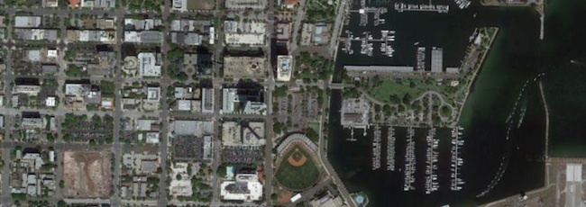
First up, we’ve added additional layers to give you access to high-resolution imagery data while in the field. Google’s Satellite and Hybrid views provide enormous levels of detail for places all over the world. Google’s expansive imagery database will give even rural and remote users access to quality imagery while on the go. The available imagery improves all the time.
Support for Overlay Layers
Upload overlay layers to use for reference while in the field. Datasets like parcel data, boundaries, routes, and other GIS layers can provide context and assistance for field data collection. These can now be added to the mobile app to view on top of imagery or other online layers. Building overlays is simple to do in TileMill, using one or a few GIS data layers (or raster layers). If you create a map with a transparent background, export to MBTiles format, and load into Fulcrum, the layer can be shown or hidden on top of the online basemap. This allows you to do things like build overlays of parcel data (like in the above screenshot), and overlay that onto the satellite imagery as a reference. Handy for all sorts of purposes.
Fullscreen Editing on iPad
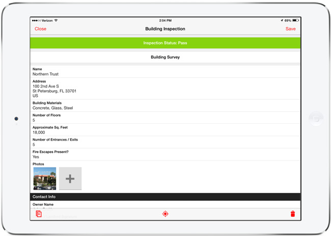
The form editing interface on the iPad has been modified to run in a full screen view, taking advantage of the larger tablet display for ease of use. This is gorgeous, and makes filling out detailed forms much easier, giving you more room for typing and data entry.
There are dozens of other small improvements all over in 2.0. Here are just a few highlights of other changes:
- Better Photo Settings - Control the size of photos to optimize upload speeds. You can now set low, medium, high, and full size native photo sizes to use with Fulcrum.
- Record search improvements - We’ve improved the search capability to navigate to data from the mobile app. Accessible right from the main screen, this will run a full-text search through the data on your mobile device.
- Filter data by project or status - Filters help to trim down the total records shown on the screen, speeding up access to the data you need to work on.
If you’ve already have Fulcrum on your device, the 2.0 version will show up as an update, or will automatically update if you have auto-update enabled in iOS 7. The 2.0 release of Fulcrum is a major improvement, and we’re looking forward to hearing how it helps improve field data collection needs with its new features and functionality.
Get the app from the iOS App Store.
Read More »Using Mobile GIS System to Offer Useful Tour Guide for Android and iOS Users
Yehliu Geopark is one of the well-known ecological scenic attractions in north east Taiwan. Its unique sea coast scenery attracts millions of tourists. As the number of applications for use with smart devices has increased, Yehliu Geopark plans to strength Yehliu e-Tour System using GIS for supporting Android and iOS devices and therefore stimulating the interaction between tourists and the e-tour service system.
To improve the quality of tourism services, Yehliu Geopark has developed the e-tour service systems for Windows Mobile and Android devices that provide the travel service with multi-media information such as text description, audio play, pictures, and combined GIS and GPS functions. Through downloading the application, Geopark in Google Play or App Stores, tourists can easily view the feature information of each scenic spot.
The new version of Yehliu e-Tour System makes the information about the surrounding of the park more interactive and digitally manipulable. Moreover, some rich games and Augmented Reality (AR) are added to allow tourists to intuitively attain the scenic spot positions. Besides, Hot News is offered to receive the periodical park event information.
In this project, SuperGIS Mobile Tour and SuperGIS Mobile Engine were adopted to develop a Yehliu e-Tour System, which contains GPS function, scenic spot guidance, Augmented Reality (AR) and basic GIS functions. After running the multi-media tour system in the park, the tourists can freely select the built-in tour routes or create their own tour route by adding scenic spots to visit.
The e-Tour System serves five major functions including Start, Scenery Introduction, Event Stamp, Hot News, and System Settings to offer enjoyable visit in the park. It not only delivers a new way to discover and learn the natural sceneries and features of the Yehliu Geopark but also helps the local government save great on producing flyers and printing cost.
Read More »
Avenza Launches PDF Maps App 2.0 on iOS Highlighting Features Requested by Avid Users
Latest Enhancements Include Real-Time Tracking with GPS and Map Features List
Toronto, ON, September 10 - Avenza Systems Inc., the leading developer of cartographic software --such as MAPublisher for Adobe Illustrator and Geographic Imager geospatial tools for Adobe Photoshop -- announced the launch of PDF Maps app 2.0 for iOS devices. Unique to the space, the enhanced version incorporates suggestions from consumers that currently use the first and only geospatial PDF and GeoTIFF reader on Apple iOS for travel, outdoor activities or business purposes out in the field. Based on the needs of its primary consumers, PDF Maps app 2.0 provides iPhone, iPad and iPod Touch users the ability to track speed and elevation in real-time and import and export data more succinctly.
The PDF Maps app takes advantage of geospatial technology that allows travelers to view and measure real world locations and attributes. Paired together with mobile devices that utilize GPS, such as an iPhone, the PDF Maps app provides constant access to geographic locations and even points of interest without the risk of losing reception due to cell tower proximity making it the ultimate travel accessory for any activity in areas where internet bandwidth is not available or while roaming outside one's data zone. With the latest updates in PDF Maps 2.0, users will appreciate the breadth of tool management features:
- Tracking real-time movement with GPS which includes noting speed and elevation statistics
- Saving, exporting and importing tracks in KML format
- Saving measurements to line data as well as importing and exporting lines in KML format
- Map Features list for easy organization of placemarks, lines and tracks including folder enhancements
- Improved export accuracy
"When we first launched PDF Maps app, we knew there was a segment of digital map users that needed something more robust than the turn-by-turn digital maps that were useful in an internet-laden urban environment, and more accessible than the expensive GPS devices that could be used offline. PDF Maps app filled that gap, and since then, we've grown a dedicated following that understands we've created a tool that supports how they want to travel, work and play... offline," said Ted Florence, President of Avenza Systems Inc. Today, we've come to a point where we can take consumer feedback and refine it in a way that benefits everyone which has been an invaluable experience for us, and we're excited to introduce the latest version of Avenza's PDF Maps app 2.0 to the map users that have provided their own insight to help create it.
Unlike other map apps that provide one view of a location using GPS coordinates as most maps do, Avenza's PDF Maps app expands a traveler's choices, allowing them to access detailed geography or points of interest created by specific map publishers for use on land, sea or air. PDF Maps app 2.0 allows consumers to access information while at a destination, providing users an opportunity to make the most of their time experiencing their environment rather than searching for cell reception to access directions.
Currently, Avenza's vast PDF Maps app library covering maps for domestic and international travel includes more than 100,000 maps organized by state and area. All maps available through the in-app iTunes-like map store offer the following capabilities:
- Access and load maps through in-app purchase, iTunes File Sharing, Wi-Fi or cellular network to read maps anytime
- Access and interact with saved maps without the need for a live network connection (offline)
- View your location on the PDF map using the built-in GPS device or via Wi-Fi triangulation
- Find coordinate of any location in the map, including the ability to type in a coordinate to search
- Display coordinates as Lat/Long (WGS84), Lat/Long (Map Default), Northing/Easting, or Military Grid Reference System (MGRS/United States National Grid (USNG)
- Support for GeoTIFF files to create tiles similar to how a geospatial PDF is tiled
- Map rendering in higher resolution
- Overlay Google search results
- Add waypoints and collect/record information about locations, including photos
- Measure distances and areas
- Open current map extents in the Maps app
- Quickly view, zoom and pan maps using gestures (pinch, drag and flick, double tap)
- Change pin colors, position and label names
PDF Maps app 2.0 is available now on the iTunes App Store free of charge for personal and private use. Commerical, government and academic use licensing is available for a nominal fee. For more information about PDF Maps, visit the Avenza website or the PDF Maps website. Pricing of each map is set by the publisher and free maps remain free to users through the PDF Maps app in-app store.
More about Avenza Systems Inc.
Avenza Systems Inc. is an award-winning, privately held corporation that provides cartographers and GIS professionals with powerful software tools for making better maps. In addition to software offerings for Mac and Windows users, Avenza offers value-added data sets, product training and consulting services.
Read More »