The popular open source web mapping library OpenLayers 3.5.0 has been released. Some of the new features according to the official blog: “Among the features in this release is a new snapping interaction. This can be used in conjunction with the draw and modify interactions to allow vector editing with snapping support. See the new snap example for a demonstration ...
Read More »Tag Archives: OpenLayers
OpenLayers 3.4.0 Released
The popular open source web mapping library OpenLayers version 3.4.0 has been released today. Some new features according to the announcement: “Dateline wrapping has been added for tile sources, you can most clearly see this in the new wms-tiled-wrap-180 example. The draw interaction can now draw circles as well, check out the updated draw features example and select Geometry type Circle. […] ...
Read More »Batch Geonews: QField, IndoorGML Standard, Focus on Google Maps for Work, 30m SRTM-DEM, and much more
The first batch-mode edition of the geonews. On the open source / open data front: There’s a new free course Introduction to Geospatial Technology Using QGIS (from Feb 23 - Mar 29) which also has content on GitHub Beautiful and simple, How to: watercolor pastel style in QGIS Announced is the FOSS4G-Europe conference, this time in Como, Italy, ...
Read More »Batch geonews: Google Earth API Deprecated, ArcGIS 10.3 Released, 2nd Learning QGIS, Nokia-Baidu Partnership, and much more
Here’s the last batch-mode edition of, covering most of December. Might interest some of you, Slashgeo’s posts are now mirrored on Google+. Have an excellent holiday break. On the open source / open data front: More support for the standard, GDAL GeoPackage raster support Reading for, The Book of OpenLayers 3, completed And another one announced, 2nd edition ...
Read More »Batch Geonews: Halloween Street View, Cesium 3D Terrains, India’s GNSS, Open Source Dronecode, and much more
Here’s the recent geonews in batch mode. On the open source / open data front: This is a must see, full instructions to Creating 3D terrains with Cesium Via O’Reilly, I became aware of Google’s open Material Design Icons on GitHub that can certainly be used for maps, reminiscent of the Maki and WorldWeatherSymbols amongst a few New lab, University ...
Read More »Webbrowser: Save maps for offline usage - Opensource solution
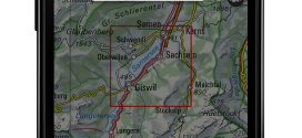
map.geo.admin.ch : now with offline function for usage in areas without network coverage Accessing maps in areas without network coverage is now possible with the map viewer of the federal geoportal, map.geo.admin.ch. A new function allows the download and local storage of a predefined map extent for offline usage. This new feature will meet the needs of individual users and ...
Read More »map.geo.admin.ch wins prize for the use of open source software

Out of 23 applicants map.geo.admin.ch received the Open Source Software Award. The prize was awarded by the Swiss Open Systems User Group / ch / open on October 8. The implementation of the geoinformation act based on the consequent adoption of open source software, open standards and cloud was rewarded. The innovative use of currently available technical possibilities ...
Read More »Batch Geonews: Book of OpenLayers 3, 30m Worldwide DEM, U.N. Guide to GeoStandards, and much more
Here’s the recent geonews in batch mode, covering most of September up to today. On the open source / open data front: It’s there now, announcing the release of The Book of OpenLayers 3 Be ready, within a year we’ll have all SRTM-DEM Level-2 (30m) data for the whole world, NGA Releases Hi-Res Elevation Data Here’s the Heron Mapping Client, ...
Read More »OpenLayers 3.0 Released
This is major news. The open source OpenLayers library is one of the most widely used web mapping software. After a complete overhaul of the venerable 2.x branch, OpenLayers 3.0 has been released. From the announcement: “This release includes a ton of new features such as an easier to use API as well as improved vector rendering and image manipulation. […] ...
Read More »Batch Geonews: Google Drone Delivery, Galileo Satellites Failures, 100 New 3D Cities for Bing Maps, 1M NYC Buildings in OSM, and much more
Here’s the recent geonews in batch mode. On the open source / open data front: A webinar Friday next week named Introducing the QGIS Academy Project Nice to see, Over 1 million New York City buildings and addresses imported to OpenStreetMap Because that’s the kind of maps we want to show our friends, Showing geotagged photos on a Leaflet map ...
Read More »