Here comes SuperSurv 3.3 for Android! To meet the great needs of high accuracy field survey and better data collection workflow via smart device, SuperSurv announces the latest version, allowing users to make the best use of the raster dataset and survey with professional external GNSS receivers. The system that has been being refined for bringing better user experience and ...
Read More »Tag Archives: SuperGIS
Perfection and Profession. Meet the Brand New SuperPad 3.3!
It is really our pleasure to share with you that the latest version of the SuperPad released for global users. Supergeo R&D team have been focusing on usability and reliability to bring the best mobile GIS experience and data quality to users during preparing and developing this annual updates, making sure that all the new functions like NTRIP extension, Z ...
Read More »Supergeo Launches the Newest SuperGIS Network Analyst 3.2
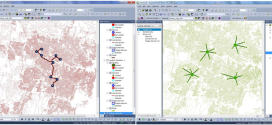
Supergeo Technologies Inc., the global leading GIS software and solution provider, launches the newest SuperGIS Network Analyst 3.2 with stronger analysis performance and computing methods. SuperGIS Network Analyst 3.2 enables users to analyze routing problems in multiple applications, such as transportation planning, tourism shortest analyst, underground pipelines planning, convenience store location deciding, service distribution etc. Through the analysis program, users ...
Read More »Supergeo Awards Reseller of the Year to Helix S.r.l., Italy
Supergeo Technologies, the global leading GIS software and solution provider, announce that Helix S.r.l., Italy is awarded as Supergeo Reseller of the Year for their contribution to creating important client base and brand awareness in the EU. The two companies started to collaborate in when Helix S.r.l. firstly developed mobile GIS program for civil services by SuperGIS Mobile ...
Read More »Latest SuperGIS Desktop 3.2 Enhances Map Display Performance and Analysis Functions
Developed by Supergeo, the latest Desktop GIS, SuperGIS Desktop 3.2 now provides users with a more powerful and comprehensive platform to display and edit GIS data by improving stability, accelerating map display performance and adding more analysis tools. SuperGIS Desktop 3.2 integrates abundant GIS tools to offer users from various domains a professional platform for geoprocessing, analyzing, displaying, editing, managing, ...
Read More »Supergeo to Release Forest Inventory App for Android Users
Forest Inventory App, an Android app designed for forest information collection, developed by Supergeo, will be released to provide forest investigators with a professional and handy tool for field survey and data recording in forests. With this App, natural resource managers can quickly record the required information during field survey and improve task efficiency. Integrating with GIS and GPS technologies, ...
Read More »Mapping and Collecting Geospatial Data with iOS
Supergeo Technologies Inc, the leading global provider of GIS software and solutions, announced that SuperSurv 3.2 (iOS), professional mobile GIS App, supports French user interface and Lebanese coordinate system. The new updates enhance manipulation convenience and provide a powerful GIS survey app. SuperSurv (iOS), GIS data capture app, is designed for geospatial data collection via iPhone and iPad. Integrating with ...
Read More »SuperGIS Spatial Statistical Analyst 3.2 Released Globally
Supergeo Technologies, a leading global provider of GIS software and solutions, officially launches SuperGIS Spatial Statistical Analyst 3.2 with powerful functions and optimization of interface for worldwide users. SuperGIS Spatial Statistical Analyst 3.2 integrates geo-statistical analysis and geographic information technologies to perform various types of analyses. The extension in SuperGIS Desktop 3.2 allows users to utilize GIS to display spatial ...
Read More »Philippine National Irrigation Systems Upgrades Parcel Maps by SuperGIS Desktop
Supergeo Technologies, a leading global provider of GIS software and solutions, announces that Philippines National Irrigation Systems (NIA) upgrades the country’s parcellary maps through SuperGIS Desktop to elevate the efficiency of irrigation planning and billing for agricultural development. With the assistance of RASA Surveying, Supergeo partner in the Philippines, National Irrigation Systems (NIA) utilizes SuperGIS Desktop 3.2 to upgrade parcellary ...
Read More »Hong Kong Polytechnic University Empowers GIS Analyst with SuperGIS Desktop
Supergeo Technologies, the leading global provider of GIS software and solutions, announces that Hong Kong Polytechnic University (HKPU) selects SuperGIS Desktop through Star Vision, Supergeo certified reseller, to educate the youths in utilizing GIS technologies and empower GIS analyses. HKPU is one of the most reputed universities in Asia. Its department of Land Surveying and Geo-Informatics has devoted to training ...
Read More »