It is really our pleasure to share with you that the latest version of the SuperPad released for global users. Supergeo R&D team have been focusing on usability and reliability to bring the best mobile GIS experience and data quality to users during preparing and developing this annual updates, making sure that all the new functions like NTRIP extension, Z value, Bing map support etc. work perfectly with the refined main structure.
SuperPad 3.3 is a full-function mobile GIS application which contains the powerful and complete GIS functions as well as a superior price-performance ratio, helping field-based users to collect, edit, display and measure spatial data with a reasonable budget. Its highly flexible development environment and diversified extensions also enable users to create ideal platforms and meet more demands of diverse tasks. Moreover, SuperPad now integrates with the latest cloud technology which allows data synchronization between mobile platform and enterprises’ server, significantly improving the efficiency of field works.
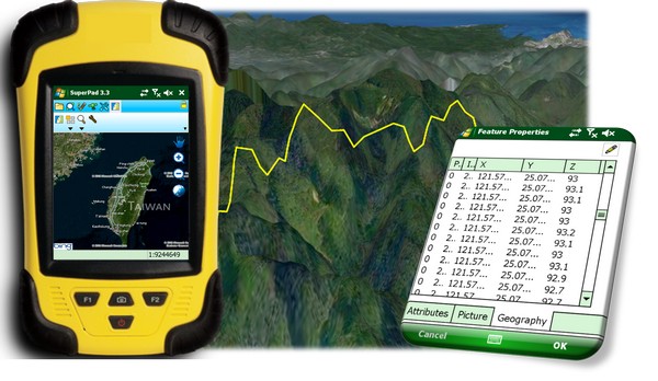
It is rather remarkable that the NTRIP extension within SuperPad 3.3 allows users to apply NTRIP Caster service like virtual reference station (VRS) RTK service provider or private station services for getting much precise field data. Besides, the built-in command lines widely supported mainstream GNSS modules, including U-Blox, Hemisphere and Novatel, also helpful for saving time in configuration and command giving. To make better use of the field data, the new SuperPad allows user to edit the Z value in geometry of all the feature layers, and automatically records the observation height while collecting data via GNSS. In addition, the Online Map Tool now allows users to overlay the Bing Map through much easier steps. Furthermore, the STC cache map format supporting function is enhanced as well and ready to meet all the basemap demands from field workers.
Feel free to download the trial from:
# # #
About Supergeo
Supergeo Technologies Inc. is a leading global provider of GIS software and solutions. Since the establishment, Supergeo has been dedicated to providing state-of-the-art geospatial technologies and comprehensive services for customers around the world. It is our vision to help users utilize geospatial technologies to create a better world.
Supergeo software and applications have been spread over the world to be the backbone of the world’s mapping and spatial analysis. Supergeo is the professional GIS vendor, providing GIS-related users with complete GIS solutions for desktop, mobile, server, and Internet platforms.