Augmented and virtual reality are pertinent to geospatial at least for the part where it allows to visualize 3D content and furthermore visualize this content in a location-based context. That’s why I’m sharing with you the news of Microsoft Goggles named Project HoloLens (also discussed over Slashdot). They’re not the first ones of course, with Google Glass and Oculus Rift ...
Read More »Tag Archives: Microsoft
Batch Geonews: TIGER, ArcGIS for WordPress, RTK GPS for $2k, Yosemite Fires, and much more
Catching up the August geonews, we're now all up to date with this way too long entry.
On the open source front:
- The new open source GraphHopper Maps – High Performance and Customizable Routing in Java based on OpenStreetMap data (via OSM)
- Here's Quantarctica, a free GIS package for Antarctica, the basic package is 7 gigs of free geodata and works with QGIS
- MapBox has an entry on the US Census Bureau released the version of TIGER
- There's more of those, the first Open Source Geospatial Lab in Switzerland is established at SUPSI, Ohio's First Open Source Geospatial lab will be established at KSU, and another one, First Australian Open Source Geospatial Laboratory at the University of Melbourne
- Frequent improvements, GeoTools 9.5 Released, GeoServer 2.3.5 Released, and Geopaparazzi 3.6.0 is out
- MapGuide Open Source is still alive and a major release planned for next year, meanwhile, Announcing: MapGuide Open Source 2.4.1 and 2.5.1
- Try open source software easily, OSGeo-Live 7.0 Released
On the Esri front:
- WordPress and Esri are both very popular, this gives us a WorldPress Plugin for ArcGIS Online: Spatial-Blogging for all Bloggers
- Esri released ArcGIS for State Government
- Here's an open source boilerplate for ArcGIS API for Javascript apps
- From Esri Press, the second edition of book 'The GIS 20: Essential Skills'
- MS and Esri, Bing Maps Use in ArcGIS Has Changed
- Updates, ArcGIS API for JavaScript Version 3.6 Released and ArcPad 10.2 Released
Discussed over Slashdot:
- More free data, Using Zillow's Creative Commons Neighborhood Boundary Data For the U.S.
- Microsoft acquires a part of Nokia, including access to Nokia mapping services
- Patents block innovation, How Patent Trolls Stalled a New Transit App
- Mapping unhappiness, Twitter-Based Study Figures Out Saddest Spots In New York City
- With MapBox behind, Open Source Mapping Software Shows Every Traffic Death On Earth, on a similar topic, Visualizing New York’s Road Accidents With the Interactive ‘Crashmapper’
- Old maps, Ostrich-Egg Globe Believed Oldest To Show New World
- More competition for driverless cars, Nissan Plans To Sell Self-Driving Cars By
- Sharks with lasers? Great White Shark RFID/Satellite Tracking Shows Long Journeys, Many Beach Visits
In the miscellaneous category:
- Another insightful entry from Brian Timoney, with an example of how difficult it can be to simply get the latest US state boundaries
- Kickstarter to get a 4-cm accuracy real-time kinematic GPS for only 2,000$, named Piksi
- OGC standards and Advancing Toward Spatial Data Quality Assurance
- MapBox has been testing their upcoming quick access to satellite imagery 'MapBox Satellite Live'
- Another research indicating using GPS negatively impact our internal picture of the world
- MapQuest wants to stay relevant with their new spatially aware Data Manager API web service
- Here's the YouSayCity, a 3D tool to discuss and document the future of individual cities
- Not directly geospatial, Discover the World's Greatest Internet Cities
- While it's a rather poor game, gamification of crowdsourcing geospatial data is here, this example of the Landspotting iPad app to crowdsource satellite imagery classification in a game, I preferred the Kort game to improve OpenStreetMap
- Wired shared an article on Google Map Maker, OpenStreetMap and the State of Crowdsourced World Mapping
- Nothing surprising, Apple too will leverage its users, iOS 7 Will Ask Users To Help Improve iOS Maps, Apple also acquired Embark to Further Improve Mass Transit Navigation
- In-the-house mobile devices, Are Mobile Users Really Mobile? Not So Much
- With Agile everywhere, it's Agile somewhere, 17th AGILE Conference on Geographic Information Science
- Don't know how many people there is an in area? Use the pickle consumption index
- Something we heard before, the geospatial identity crisis and the term 'geomatics'
- We mentioned it in and here's an updated about Gmap4: REST and WMS Map Viewer for Google Maps and GIS Data
- Another OGC entry, this time on big data and Big Processing of Geospatial Data
- A generic NYT article on Microsatellites: What Big Eyes They Have
- Drones again, Light-weight UAV-mounted laser scanning system announced
- Future unevenly distributed, Video Flashback 1987: Star Trek's Shatner Tells You Where You Can Stick Your Maps
- Pretty interesting, geo doesn't have to be that complex, James Fee shares GIS Is Complicated by Design
In the maps category:
- Yosemite fires entries: The Fire Last Time: Mapping Blazes Past, Present - and Future, 6 Months of Wildfires Burning North America, and Yosemite Fire’s Destruction Mapped in Beautiful, Frightening Color
- Another source for marine traffic, Visualize and Monitor Maritime Vessels, Real-time on Google Earth
- Map of Nobel prizes, A visual exploration of the Nobel Prize history
- An printed atlas, Atlas of the World Wide Web
- Maps of war, Targeting Sites of Attack in Syria
- Correlation is not causation, maps of Milk, the Drink of Conquerors
- Via Wired, don't miss (really) this London’s Underground With This Mesmerizing Interactive 3-D Map
- On a similar topic, the Interactive Map of the Paris Metro
- A new version, the nice Submarine Cable Map
Batch Geonews: New Google Maps App, 3D Printing in Windows 8.1, GeoServer Enterprise, MapBox Real-time Satellite Imagery, and much more
Here's the geonews in batch mode. Some of them may have deserved their own entry.
On the open source / open data front:
- OpenLayers 2.13.1 has been released, but arguably more exciting is OpenLayers 3.0 - alpha.2, they're getting closer
- W3C is Launching the Open Data Directory
- Introducing GeoServer Enterprise, it's GeoServer with long term support releases and more
- Here's the FOSS4G-CEE Bucharest, Romania final thoughts
- Montreal's public transport organization adopted OpenStreetMap for their maps, another example of how mature enough OSM has become
- Nokia uses the open source CartoDB to show off traffic data
- Good news, California Supreme Court Says GIS Data are Public Data
On the Esri front:
- It was the Esri User Conference this week, you can read Geoff's 3D and other themes of this year's conference entry
- Jack Dangermond explaining How Esri Hit $912 Million in Sales, very interesting, including: "One thing that has made us so successful is that we've never taken outside investment. That means we can concentrate on what our customers want--not what the stockholders or the VCs want. That's a strategic advantage."
- You'll find a lot lot more on the Esri blog for the International User Conference
- New imagery for Esri tools, DigitalGlobe and community imagery added to the World Imagery map
- ArcGIS Online just got more advantageous, Get More with ArcGIS Online – Announcing Subscription Savings
On the Google front:
- Google announced their new Google Maps app for smartphones and tablets
- Also over Slashdot, Google Updates Maps, Makes First Stable Chrome Release Using WebKit Fork
- Rest reassured, the iOS Enhanced Google Maps App with iPad Support 'Coming Soon'
- Unsurprisingly, there was New Google Earth Imagery – July 8
Geo-related news discussed over Slashdot:
- Microsoft Reveals Its 3D Printing Strategy For Windows 8.1
- 3 GLONASS-M GNSS satellites destroyed, Russian Rocket Proton-M Crashes At Launch
- MapBox is aiming at nothing less than Real Time Imagery via MapBox Satellite Live
- But that's clearly the beginning, read APB's entry named Real-Time Data is Really Here ... Kind of, Almost
- Again, City-Sized Ice Shelf Breaks Free Of Antarctica
- New Zealand ISP Offers "Global Mode" So Users Can Circumvent Geo-Restrictions
- Something we discussed before, Automated Plate Readers Let Police Collect Millions of Records On Drivers
- UCSD Lecturer Releases Geotagging Application For "Dangerous Guns and Owners"
In the miscellaneous category:
- Interesting, O'Reilly shares news about Sifted, a 7-minutes animation set in a cloud points world, geo-geeky
- A Newly Published Apple Mapping Patent Details Route Feedback System, Real-Time Accident Reporting
- O'Reilly mentions Cricket, an indoor location system from MIT, but the latest news appear to be from
- If you're into Minecraft, you'll like Hangouts with James Fee:: Professional Minecraft GIS
- Here's starting points regarding Cross Platform Development with Bing Maps and PhoneGap
- In the U.S., Round-the-clock GPS tracking of state worker ‘unreasonable’ (via SL)
In the maps category:
- A series of maps on Who Serves in the U.S. Military? Mapping Enlisted Troops and Officers
- Here's Midtown Manhattan Growth Animation (1850-2015) and Toronto Growth Animation (1834-2013) and San Francisco Growth Animation (1877-2015) and Calgary Growth Animation (1892-2016)
- Now available, a New global ESA Vegetation Map
Microsoft Previews GeoFlow for Excel: 3D Visualization and Storytelling
Via APB I learned about the public preview of Microsoft's project codename “GeoFlow” for Excel, which delivers 3D data visualization and storytelling. Considering the dominance of Microsoft Excel in multiple sectors, it may become a popular mapping tool.
From their Excel blog announcement: "GeoFlow lets you plot geographic and temporal data visually, analyze that data in 3D, and create interactive "tours" to share with others. [...] With GeoFlow, you can:
- Map Data: Plot more than one million rows of data from an Excel workbook, including the Excel Data Model or PowerPivot, in 3D on Bing maps. Choose from columns, heat maps, and bubble visualizations.
- Discover Insights: Discover new insights by seeing your data in geographic space and seeing time-stamped data change over time. Annotate or compare data in a few clicks.
- Share Stories: Capture "scenes" and build cinematic, guided "tours" that can be shared broadly, engaging audiences like never before."
Related, Esri Maps for [Microsoft] Office 2.0 was released earlier this month.
Read More »Batch Geonews: 3D Printing Pen, OGC’s GeoPackage Standard, ArcGIS Explorer 2500, Major Bing Maps Updates, and much much more
Here's the geonews in batch mode, unusually covering 4 weeks, thus a much longer issue.
On the open source / data front:
- With the GeoPackage standard in the oven and its opportunity to replace the aging shapefile format, read this very pertinent summary named Takeaways from OpenGeo’s Comments on OGC and the Proposed GeoPackage Specification
- An interesting entry on TileMill for Raster Analysis
- In the same vein, expanding TileMill's Building Symbolizer to Visualize Complex 3D Structures
- EasySDI V3 is now available
- The open source virtual globe Marble 1.5 is now available for MacOS X
On the Esri front:
- A book review of "Python Scripting for ArcGIS" by Paul A. Zandbergen
- A new version, and here's what’s new in ArcGIS Explorer Desktop 2500
- The ArcGIS Query Analysis Add-In is available for download
- Here's the ArcGIS Online World Topographic Map February updates and here's the previous update
- ArcGIS applied to tennis, Using spatial analytics to study spatio-temporal patterns in sport
- APB shares a Esri Federal GIS Conference News Roundup
On the Google front:
- Google announced that Public Alerts for Google Search, Google Now and Google Maps available in Japan
- The official entry on Expanding Street View in Europe
- The GEB again mentions Tracking Satellites in Google Earth, this time linking to the new SightSpaceStation website
On the Microsoft front:
- A new Bing Maps Tech Preview at TED Conference: "a new twist: the ability to mine Flickr for geotagged photos and overlay onto Bing Maps streetside imagery for a perfect visual lock"
- Bing Maps got a major overhaul, 46.7 TB of new imagery and a Silverlight version of Bing Maps... I though Silverlight was abandoned?
- Here's the entry on the New Top of the World and High Resolution Satellite Imagery
- An entry on Bing Maps REST Service Tips & Tricks
- And New to REST Services: Elevations API and 3D Elevation Models with Bing Maps WPF
- And training for apps builders, Bing Maps for Windows Store Apps Training Kit
Geospatial-related discussions over Slashdot:
- Startup Uses Radiation Fear To Map Cellphone Coverage
- Fox News: US Solar Energy Investment Less Than Germany Because US Has Less Sun, comparing maps, it's simply far from the truth
- The US Redrawn As 50 Equally Populated States
- Drones Still Face Major Hurdles In US Airspace and AirBurr UAV Navigates By Crashing Into Things
- Canon Demos New Head-Mounted Augmented-Reality Display
- Texas Bills Would Bar Warrantless Snooping On Phone Location
In the everything else category:
- A lot of sources mentioned 3Doodler: The World's First 3D Printing Pen, while not entirely geospatial-related, 3D printing is mainstream now
- APB shares an entry on a Free e-Book on Online GIS which compares ArcGIS Online, CartoDB, CloudGIS, GeoCommons, MangoMap and MapBox
- Trying to amend myself for not having shared this before, here's How Interactivity Works with UTFGrid for web maps, along with a visual demo, and an example using OpenLayers
- APB has an entry named U.S. House Representatives Introduce Online Communications and Geolocation Protection Act
- Everything is a geospatial sensor, Rain tracked with mobile network
- A milestone release, MapBox iOS SDK Goes 1.0.0 + New Features
- MapQuest Introduced Free Travel Blogs to help people share their travel adventures
- Mapperz mentions that the USPS Mapping Tool allows you to pick your own delivery routes
- APB links to an article named How Google And Bing Maps Control What You Can See
In the maps category:
- We presented a world map of undersea internet connections, here's the interactive Submarine Cable Map
- Scary, maps of the U.S. Geography of Sin, and here's the U.S. Geography of Happiness
Batch Geonews: JS.geo, Instant StreetView, 3D Printing, Drones, Autodesk in the Cloud, and more
Here's the recent geonews in batch mode.
From the Esri front:
- An interesting entry on Designing the next generation of online Topographic Maps
- There's an ArcGIS Online World Topographic Map New Design which includes High-resolution imagery for South America, Australia, New Zealand, and Afghanistan
- The Esri U.S. Demographic Data Release
On the web maps front:
- We mentioned it before, and here's more details on JS.geo: A Meeting of Javascript Mappers in Denver
- There's a new site to give you Instant Google Street View (direct link)... worth trying, it's really fast
- Also Google-related, the GEB talks about GPS4Sport that combines GPS with Video and Google Earth
-
On Apple Maps
- Rumors of OS X 10.9 to Include Siri and Maps Integration
- A lot of geoblogs mentioned that Apple axed the head of its mapping team, Richard Williamson (more here)
- Microsoft added New Imagery Added to Windows 8 Maps App & Bing Maps
- The MapBox iOS SDK hits version 0.5.0
- Two weeks ago, TomTom launched its SDK for LBS Apps, including maps, geocoding, routing, traffic
In the miscellaneous category:
- Launched less than 10 days ago, MarineRegions, "towards a global standard of georeferenced marine names" (via Kurt)
- A slashdot story named French Company Building a Mobile Internet Just For Things
- While 3D printing have most of its applications outside of geospatial, I found interesting that it's really going mainstream as demonstrated by Staples To Offer 3D Printing Services, an O'Reilly story named Printing ourselves, the state of 3D Printing Patent Suits (via OR), and yes, you can 3D-print your own drone
-
More news about drones:
- The Make magazine offers a gift guide for aerial drones (via OR)
- But beware, High Levels of Burnout in US Drone Pilots (via OR)
- VerySpatial offers an entry on Forensic GIS and the Role of Geospatial Technologies for Investigating Crime and Providing Evidence
- Apparently, there's Nokia offline maps available in Firefox OS (alpha)
-
If you're excited by OGC standards
- There's the development of an international standard for 4D archaeological data
- And soon, Augmented Reality Standard ARML 2.0 in its Final Stage
- If you're in the U.S., you'll be interested by the GAO Report on Federal Geospatial Data Coordination
- You wonder about earth observation satellites from Russia? Here's news about the Resurs-P with 3-m hyperspectral capabilities and other Russian satellites
- As part of Autodesk University, you'll find the Autodesk CEO saying “I do believe that everything is moving to the cloud.” and an entry indicating that Autodesk's future is in the cloud
In the maps category:
- Interesting maps, U.S. Geography of Personality: The United States of Mind
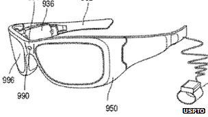
Microsoft Granted Patent For Augmented Reality Glasses
Google are not alone looking at augmented reality glasses, Slashdot discusses a story named Microsoft Granted Patent For Augmented Reality Glasses. Previous Google Project Glass stories.
Their summary with link to a BBC article: ""A patent granted to the U.S. tech firm describes how the eyewear could be used to bring up statistics over a wearer's view of a baseball game or details of characters in a play. The newly-released document was filed in May and is highly detailed. ... Although some have questioned how many people would want to wear such devices, a recent report by Juniper Research indicated that the market for smart glasses and other next-generation wearable tech could be worth $1.5bn by and would multiply over following years." - Noticeable differences from Google's version: two lenses, a wrist computer, and wires."
Batch Geonews: SotM US, GIS Interview Questions, Verizon Tracks Customers, U.S. Election Map, and much more
Here's the recent geonews in batch mode.
On the open source / open data front:
- Here's an excellent summary of OpenStreetMap's State Of The Map US -, on Steve Coast's presentation, Dr JTS shared: "He said that the top thing OSM needs to continue to grow is addressing. He singled out Google Mapmaker as being a clear and present danger to the growth of OSM."
- James shows us how to easily download OpenStreetMap data from WeoGeo
- There's a new Open Source Geospatial Research and Education Lab established at North Carolina State University
- MediaGoblin, an open YouTube, Flickr and the like competitor, now supports 3D models
- If you're interested by the uDig desktop GIS, there's now video tutorials
- You can publish maps direction from ArcGIS to MapBox Publishing with Arc2Earth Sync
- There's even more and updated OpenStreetMap tiles offered by MapQuest
- Here's how to create dynamic contour maps with server-side processing with WPS, GeoServer and PostGIS 2.0
- GeoServer 2.2.1 has been released
On the Esri front:
- Using ArcGIS Online? There's a the ArcGIS Online Health Dashboard, to let you know if any service is down
On the Google front:
- The GEB tells us about Tracking KMZ file usage with Google Analytics
- Here's an entry on Trekking the Grand Canyon for Google Maps, for Street View of course
On the Microsoft front:
- The ridiculous patent war continues, Microsoft Sues Motorola Over Mapping Patents
- A U.S. State identification game for MS MapPoint
Geo-related Slashdot discussions:
- I had to happen, Apple Maps Accidentally Reveals Secret Military Base In Taiwan
- Remote sensing helped monitor a Huge Geoengineering Project Violates UN Rules on Canada's west coast
- An Arctic Investigation Underway Into Solar Storm Sat-Nav Disruption
- We'll probably see this often, Texas Schools Using Electronic Chips To Track Students; Parents In Uproar
- Implementing geospatial isn't always easy, Uber [mobile app] Gives Up On New York Taxi Service
- Privacy is dead right? How Hair Can be Used To Track Where You've Been
- Reusability, NASA Working On Refueling Satellites
In the everything else category:
- Using Verizon? They sell where you are; Verizon Sells App Use, Browsing Habits, Location (via O'R)
- DM shares an article named Prepare to Get That Job: 20 Challenging GIS Interview Questions, and also related to jobs, GeoSearch Tracks U.S. Geospatial Employment in Q3
- Drones for geospatial? Home-made 3D-Printed Drones (via O'R)
- The promise of WebGL, while this article isn't specifically on geospatial uses of WebGL, it's worth taking a look at the WebGL demonstration video (wait at least until colors kick in, after about one minute)
- Fearing supervolcanos? For those in South America, ESA's story on the 'sombrero uplift' seen by remote sensing, the largest active magma body in Earth's continental crust
- Geospatial brings value? A DM article on Location Intelligence unlocks the power of your data
In the maps category:
- Good timing, United Swing States of America: Presidential Election Battle Map
- Several readers might be interested by North American Cartographic Information Society's Atlas of Design, now available
- APB reports on that the UK Met Crime Map is Overwhelming for Users
Batch Geonews: Shapefiles in Bing Maps, 80% of Data is Not Spatial?, In-Location Alliance, ArcGIS for AutoCAD 300, and much more
This is my tentative to catch up the geonews since my mid-August holidays. Here they are!
On the open source / open data front:
- UDig 1.3.2 has been released with several new features and supports Axios spatial editing tools again
- Since the USGS provides the Landsat archive, but this entry mentions that a substantial part of the Landsat archive is available on the fast and reliable public Google Earth Engine cloud storage
On the Esri front:
- The free plugin ArcGIS for AutoCAD version 300 is now available
- There's now an ArcGIS Runtime for iOS for ArcGIS WebMaps
On the Google front:
- Google made a few Google Maps announcements, including voice guided directions in India, Map Maker in New Zealand and new Street View in 150 university campuses
- In another entry, Google offers a roundup of their August Google Maps related news, most news we already shared with our users
- Nothing surprising, new imagery released on September 1
On the Microsoft front:
- Microsoft shares an entry on overlaying Esri shapefiles in BIng Maps
- Microsoft's Global Ortho Project is complete for the United States, meaning there's high resolution 30cm imagery everywhere in the country
- There's a new Bing Get Me There App for iOS for London, UK
- An entry on Bing Maps V7 AJAX Highlights
In the everything else category:
- James shares a must-read short entry named '80% of Data Is Not Spatial So Stop Claiming It Is', read the comments for insights
- Here's a pertinent entry related to a UN paper, Criticism - Future Trends in Geospatial Information Management: The Five to Ten Year Vision
- Here's an update on the OGC standards and the semantic web (aka Linked Data)
- APB informs us that 22 companies formed the In-Location Alliance to Enhance Indoor Positioning
- O'Reilly links to an article on Yelp Checkins to Measure Geopositioning Accuracy Across Phones
- Slashdot discuss the Location Privacy Act Approved By California Legislature
- Other stories at Slashdot, The Rapid Rise of License Plate Readers and UK License Plate Cameras Have "Gaps In Coverage"
- Big numbers, APB indicates that the GIS market will soon reach between 3.7 - 10.6 Billions, depending on who you ask
In the maps category:
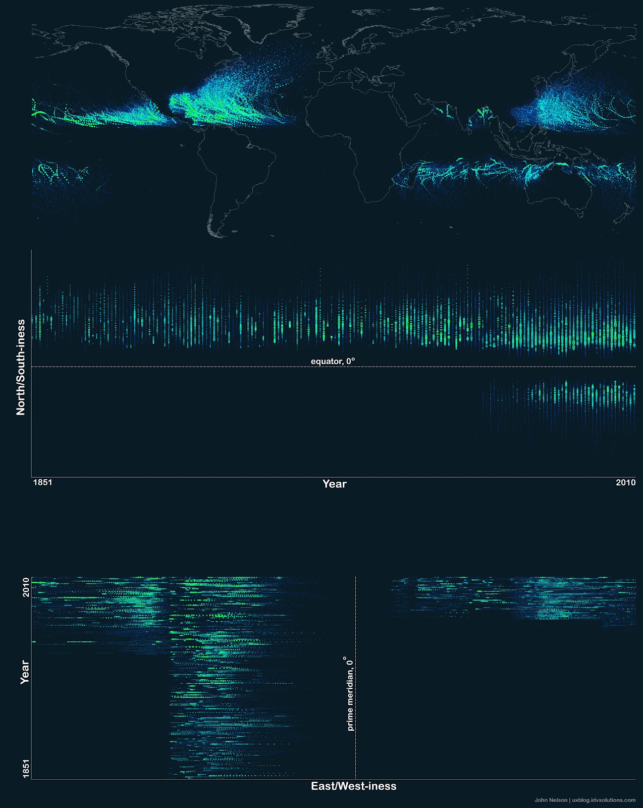
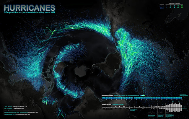
- On APoD, there's a pretty interesting map of hurricane and tropical storms paths (screenshot below)
- An interesting map of the Global Decline in Religiosity
- Some London Olympics maps: The politics of London Olympic medal counts
Batch Geonews: OpenStreetView, 215TB of new Bird’s Eye Imagery, Omnipresence of the Google Maps API, and more
Here's the recent geonews in batch mode. It excludes Esri-related geonews since I wait for the conclusion of the User Conference to share an aggregated entry. Also to note, this week some of our users finally get our daily newsletter in their inboxes after an absence of over a year - the problem was that it was identified as 'spam' by a 3rd party filtering system - thanks to the user who reported this issue!
On the open source front:
- It's in a James Fee rant named Google Maps Is More Accurate Because They Say It Is, I learned about the OpenStreetView, you guessed it, an open version of Google's Street View
- A few weeks ago, we mentioned FOSS4G in Beijing being cancelled, here's the related official OSGeo board reaction
- Here's an entry on Creating contour lines with GDAL and Mapnik
- A technical entry named Manipulating GPS tracks in Spatialite
- Time flies, QGIS Is Ten Years Old
On the Microsoft front:
- Microsoft released an impressive 215TB of new Bird's Eye imagery: "spans across the United States and features certain areas in Europe, Australia, New Zealand and Tokyo"
- In an entry, Microsoft details the Bing Maps keys, including the limitations of what you can do for free
Discussed over Slashdot:
- Dr. Faragher Answers Your Questions About the Future of Navigation Technology, he's the Principal Scientist at the BAE Systems Advanced Technology Centre and NAVSOP supporter
- A discussion on Resources For Identifying Telecom Right-of-Way Locations?
- Australian Consumer Group Wants Geo-IP Blocking Banned "saying it created significant barriers to the free flow of goods and services"
- Samsung Galaxy S3 Stripped of Local Search
In the miscellaneous category:
- Pretty interesting stat: 93% of the top million sites and 89% of the top 10,000 sites on the internet with maps are using Google maps or the Google maps API, this comes from this overview of statistics for mapping technologies
- Directions Mag offers screenshots in an entry named Get Ready for the London Olympics with AEgis’ 3D Models
- Via the AQT [French link], I learned about the Kessler syndrome: "[...] a scenario in which the density of objects in low Earth orbit (LEO) is high enough that collisions between objects could cause a cascade – each collision generating debris which increases the likelihood of further collisions. One implication is that the distribution of debris in orbit could render space exploration, and even the use of satellites, unfeasible for many generations."
- APB tells us that DigitalGlobe and GeoEye agreed to merge
- APB informs us that there is Nokia 4000 Indoor Maps
- Apparently, drones are an hazard to air traffic in Somalia
- The GEB has en entry on Meograph, as multimedia tool for creating Google Earth visualizations
- Long entry on MapQuest iOS Maps API 1.0.1 released and their official announcement of their iOS Maps API
- The US NGA released its Strategic Plan-2017
- An interesting short entry, Starbucks: 1 Store = $1 Million Investment and GIS Helps Get It Right
In the maps category:
- Via O'Reilly, you can read Google's Ed Parson in an short article named The Future of the Map Isn't a Map at All—It's Information
- TMR shares an entry about Susan Schulten's 'Mapping the Nation' book, focusing on 19th century U.S.