Here’s the recent geonews in batch mode. From the open source / open data front: Popular nowadays, Considering a Hybrid Proprietary/Open-Source Architecture Here’s a followup regarding the Open Letter for LiDAR standards, for which Esri’s Jack Dangermond himself provided feedback With the open source GeoMesa that is almost ready for release, Google & GeoServer Support Geospatial Big Data in the ...
Read More »Tag Archives: 3D
Improve Underground Utilities Management and Public Safety by 3D GIS
Developed by Supergeo Technologies, SuperGIS 3D Earth Server is going to support underground utilities management. The breakthrough tech enables administrators to comprehend the distribution of underground utilities that cannot be seen in daily life and to arrange urban plans and make policies and decisions with full-scale perspective. The underground pipelines, usually distributed near to the places with crowded population, ...
Read More »Batch Geonews: Google Working with Esri, ArcGIS Pro Released, Turf 1.4.0 Released, Facebook using iBeacons, and much more
Here’s the recent geonews in batch mode. On the open source / open data front: That’s fast development, the open source Web GIS Turf 1.4.0 has been released with several new interesting features, if you don’t know Turf, look at it now, it’s part of our geofuture I learned about OpenChargeMap in this discussion named Japan Now Has More Car ...
Read More »Batch Geonews: OL3-Cesium Library, Embed Street Views, OGC Web Coverage Tile Service, and much more
Here’s the recent geonews in batch mode. On the open source / open data front: The new OL3-Cesium library, integrating OpenLayers 3 and Cesium together for smooth switching between 2D and 3D A new book on the open source GDAL/OGR library, “Geospatial Power Tools” by Tyler Mitchell Not directly geospatial but for 3D, Tao3D: a New Open-Source Programming Language For ...
Read More »Batch Geonews: Book of OpenLayers 3, 30m Worldwide DEM, U.N. Guide to GeoStandards, and much more
Here’s the recent geonews in batch mode, covering most of September up to today. On the open source / open data front: It’s there now, announcing the release of The Book of OpenLayers 3 Be ready, within a year we’ll have all SRTM-DEM Level-2 (30m) data for the whole world, NGA Releases Hi-Res Elevation Data Here’s the Heron Mapping Client, ...
Read More »Batch Geonews: WorldView-3 Launched, UK to Allow Autonomous Cars, ArcGIS Pro, MapBox GL, and much more
This is an unusually long edition of the geonews in batch mode, covering all of our Summer break. On the Esri front: A nice summary, Twelve Things Worth Knowing from Esri User Conference Q&A More options is good, Introducing Esri’s World Elevation Services It’s not ‘beta’ anymore, ArcGIS Open Data production APB discuss the upcoming 64-bits friendly ArcGIS Pro ...
Read More »Cesium 3D Web Mapping Library 1.0 Released
Cesium is an open-source JavaScript library for creating 3D and 2D web maps. It uses WebGL for hardware-accelerated graphics. Version 1.0 includes support for worldwide high-resolution terrain; global imagery from standards such as WMS, OpenStreetMap, Bing Maps, and ArcGIS MapServer; vector data from GeoJSON and TopoJSON; 3D models using glTF; and a large geometry library.
Read More »Superior 3D Map Viewing with SuperGIS 3D Earth Server Front-end Applications
To provide users a superior 3D map experience, Supergeo releases whole new front-end applications, the desktop client application, SuperGIS 3D Earth, and the browser plug-in, SuperGIS 3D Earth Plug-in, for SuperGIS 3D Earth Server 3.2 in enhancing map viewing efficiency. Users may choose the way they like to explore the 3D globe with ease. SuperGIS 3D Earth Server 3.2 ...
Read More »Google Launches ‘Project Tango’ 3D-Mapping Smartphone
There's already numerous apps to map our immediate environment in 3D with current smartphones, but this new Google project goes beyond, and because it's Google, the adoption potential of obviously significantly increased. MacRumors offers a nice summary along with several links in a story named Google Launches 'Project Tango' 3D-Mapping Smartphone.
From the official Project Tango site: "Our current prototype is a 5” phone containing customized hardware and software designed to track the full 3D motion of the device, while simultaneously creating a map of the environment. These sensors allow the phone to make over a quarter million 3D measurements every second, updating its position and orientation in real-time, combining that data into a single 3D model of the space around you. [...] What if you could capture the dimensions of your home simply by walking around with your phone before you went furniture shopping? What if directions to a new location didn’t stop at the street address? What if you never again found yourself lost in a new building? What if the visually-impaired could navigate unassisted in unfamiliar indoor places? What if you could search for a product and see where the exact shelf is located in a super-store?"
Here's the 3-minutes video introducing Project Tango.
Read More »Open-source 3D city platform ViziCities released on GitHub
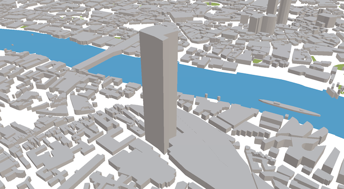
ViziCities is an open-source 3D city visualisation platform powered by JavaScript, WebGL, and OpenStreetMap. It allows you see OpenStreetMap data in 3D, anywhere in the world. A dynamic loading system allows you to move around and load new areas continuously, just like a Google Map. It's still in a very early stage, though development is accelerating now that it's open.