Supergeo, the leading GIS software and solution provider, is going to release NTRIP solution on its Windows Mobile GIS app, SuperPad, for high accurate field data collection and geospatial workflow enhancement. SuperPad is a feature-rich mobile GIS application for field-based personnel to collect, edit, display and measure spatial data at a reasonable budget. The highly flexible development environment and ...
Read More »Tag Archives: GPS
High Accuracy and Advanced Field Work with Latest SuperSurv
To meet the great needs of high accuracy field data collection and better workflow via modern GNSS technology, Supergeo, the leading GIS software and solution provider, announces the latest SuperSurv (Android), the GIS mapping app, which not only allows users to connect with and operate external Bluetooth GNSS devices, but also elevates field work efficiency with new averaging algorithms. ...
Read More »GIS Observation System Supplies Water for Lives
As the main water supply and electricity generator in great Taipei, Feitsui Reservoir is a vital resource in Taiwan. Feitsui Reservoir Administration therefore needs to ensure that water quality, water supply and the land use of catchment area are under control. To timely manage this 303 square meters reservoir, the authority decided to establish a GIS application, so that the ...
Read More »Supergeo Partners with GPS P.L to Offer iOS-powered Mobile GIS Turnkey Solution
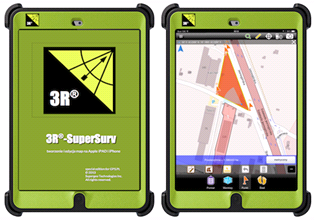
Supergeo Technologies, the leading global provider of complete GIS software and solutions, announced the successful collaboration with GPS P.L. The two companies offer iOS-powered mobile GIS turnkey solution, named 3R-SuperSurv, for more Polish and European users.
GPS.PL has nearly 2 decades experience in the field of GNSS and INS, covering diverse areas like sea, air, farming, forestry, ecology, and defense, field survey, etc. The provision of GPS.PL includes professional consulting, training, technical support, and various hardware products. Its clientele base is mainly in Poland and also expands to the neighboring countries.
The turnkey solution, 3R-SuperSurv, integrates GIS and GPS technologies, allowing users to efficiently collect GIS data, record the coordinates, display map, conduct on-screen query and measurement with their iPad. Furthermore, with the specially made three-layer shell protection, local users are empowered to utilize the rugged product for extensive applications.
The collaboration not only shows the internalization and localization of SuperGIS software in global markets, but also extends the marketing channels of SuperGIS series software to more European countries. These two companies will provide more mobile solutions for local users in near future.
# # #
About Supergeo
Supergeo Technologies Inc. is a leading global provider of GIS software and solutions. Since the establishment, Supergeo has been dedicated to providing state-of-the-art geospatial technologies and comprehensive services for customers around the world. It is our vision to help users utilize geospatial technologies to create a better world.
Supergeo software and applications have been spread over the world to be the backbone of the world’s mapping and spatial analysis. Supergeo is the professional GIS vendor, providing GIS-related users with complete GIS solutions for desktop, mobile, server, and Internet platforms.
Read More »Supergeo Renews Partnership Agreement with Géo.RM in France
Supergeo Technologies, a leading global provider of complete GIS software and solutions, announced to extend partnership with Géo.RM to cooperatively promote SuperGIS software and solutions in French-speaking countries. This collaboration would encourage greater use of SuperGIS software and solutions in France and further break into new markets in Europe.
Established in 1991 and based in Poitiers, France, Géo.RM is the professional system integrator which specializes in offering custom GPS and GIS mapping solutions, and the consulting service to fulfill the growing needs of field mapping.
In addition to reasonable prices, SuperGIS mobile GIS software such as the newest SuperSurv and SuperPad support iOS, Android, and Windows Mobile powered devices, helping users develop flexible GIS applications to improve field operations, increase accuracy of data collection, and therefore assist organizations with better decision-making.
Through extending partnership with Géo.RM, it allows Supergeo to promote SuperGIS solutions to French-speaking users. Supergeo commits to continuous product innovations and service improvement in order to support Géo.RM in finding and even creating new business opportunities.
# # #
About Supergeo
Supergeo Technologies Inc. is a leading global provider of GIS software and solutions. Since the establishment, Supergeo has dedicated to providing state-of-the-art geospatial technologies and comprehensive services for customers around the world. It is our vision to help users utilize geospatial technologies to create a better world.
Supergeo software and applications have been spread over the world to be the backbone of the world’s mapping and spatial analysis. Supergeo is the professional GIS vendor, providing GIS-related users with complete GIS solutions for desktop, mobile, server, and Internet platforms.
Supergeo is looking for business partners worldwide like UK and Germany.
Read More »Batch Geonews: Predictions, Near Real-Time Imagery of Earth, Location Privacy, LiDAR Formats, and much more
The first batch geonews edition!
On the open source / open data front:
- An informative update on the OGR OpenFileGDB driver to read Esri's file geodatabase format
- Plugin to display QGIS 2D maps in 3D in a web browser via three.js
- Interesting predictions and trends, Juan Marin’s Predictions for and Paul Ramsey’s Predictions for and MapBrief Geo Predictions
- We never mentioned the open source data portal software before, but it supports geospatial data pretty well
- Via OR, MapGive — U.S. State Dept launches OpenStreetMap contributing tool “to help humanitarian efforts”, and the State of the Map will be held in Buenos Aires
- Some software updates, MapGuide Maestro 5.1, Geopaparazzi 3.9.0 is out, SAGA 2.1.1 released, Mapbox.js v1.6.0
- Using open source software to answer Will the sun shine on us?
- Talking of the sun, News from Marble: Introducing Sun and the Moon and Planets
On the Google front:
- Really worth taking a look to Climate Viewer 3D: The Google Earth Climate Change, Pollution and Privacy Viewer
- A new book, Google Maps JavaScript API CookBook
- Viewing the Topography of the Thermohaline Circulation of the Oceans in Google Earth
- There's New 3D imagery in Tokyo and other Japanese cities
- From Slashdot. Google Removes "Search Nearby" Function From Updated Google Maps
- Why not, Creating artwork based on Street View
- If genealogy is within your interests, Genealogy through Google Earth
On the Apple front:
- Description of an Apple Maps App with Interactive Data Layers Detailed in New Patent
- Will this concept catch up? Apple's iBeacon Technology Brings New Possibilities for Location-Based Gaming
- Nokia's HERE not popular enough? Nokia Pulls 'HERE' Maps App for iOS, Citing iOS 7 Changes That 'Harm the User Experience'
Discussed over Slashdot:
- Yes, this is coming, Swarms of Small Satellites Set To Deliver Close To Real-Time Imagery of Earth another related entry is named Planet Labs to capture near-continuous whole-Earth imagery from 28 five kilogram satellites
- If you're a regular Slashgeo reader, you know this already, Why the World Needs OpenStreetMap, and it's time to migrate 'en masse' according to The Guardian
- On privacy, It's Not Just the NSA: Police Are Tracking Your Car
- But you know what? Carmakers Keep Data On Drivers' Locations From Navigation Systems
- And here's a confirmation, Ford Exec: 'We Know Everyone Who Breaks the Law' Thanks To Our GPS In Your Car
- But there's always hope? Recent Federal Trade Commission (FTC) Settlement Will Make It Harder to Collect and Share Geoinformation In US
- First step before commercial drones, Feds Announce Test Sites For Drone Aircraft
- For fun, CES: Building Self-Guiding Lego Robots for Fun and (Maybe) Profit (Video)
- There are still wonders to discover, thanks to geo, Lasers Unearth Lost 'Agropolis' of New England
- Tracking bees, Scientists Glue Sensors To 5,000 Bees In a Bid To Better Understand Them
In the everything else category:
- A geodesy dream? Affordable Arduino-Compatible Centimeter-Level GPS Accuracy
- Using LIDAR data? Read Format Wars Episode V: LIDAR, why? Esri Launches its Own Propriety Compressed LiDAR Format: .zlas
- An article on Spike, creating 3D models of buildings and things with a smartphone, not the first app of that kind but that one comes from a GIS company
- Free map online course from Coursera to begin in April
- You already know what IFTTT recipes are? Here's you'll learn about geoenabling triggers with geofences and more
- Here's about SenseFly, a drone for taking oblique imagery
- A generic entry on the Cocktail of Technologies for Smart Cities: The role of Geospatial Tech
- Wired on Tracking the Secret Lives of Great White Sharks
- Let's talk about our privacy again, DARPA’s 1.8 gigapixel ARGUS-IS: The Ultimate Surveillance System from above?, that's 1.8 gigapixels and 12 frames/second, 24/7
- On the SPOT remote sensing satellite family, up to SPOT 7, The new SPOTs
- On 3D printing, yup, really mainstream now, Adobe Adds 3D Printer Support To Photoshop and here's about the open source ' slic3r ' — converts a digital 3D model into printing instructions for your 3D printer (via OR)
In the maps category:
- On mapmaking, The Hidden Meanings of Maps: Design and Colors
- Beautiful, A woodcut inspired map for city streets
- Jonathan provides a book Review: A History of the World in Twelve Maps
- And here's A look at twelve maps that changed the world
- Don't we all like beautiful maps? Wired shares The Most Amazing, Beautiful and Viral Maps of Year
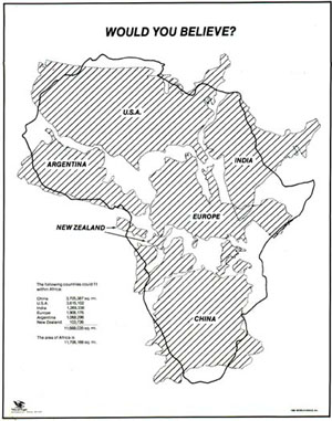
- Here's a map you have to see, would you believe how big is Africa? Mercator projections are messing with our perception of the world
Batch Geonews: TIGER, ArcGIS for WordPress, RTK GPS for $2k, Yosemite Fires, and much more
Catching up the August geonews, we're now all up to date with this way too long entry.
On the open source front:
- The new open source GraphHopper Maps – High Performance and Customizable Routing in Java based on OpenStreetMap data (via OSM)
- Here's Quantarctica, a free GIS package for Antarctica, the basic package is 7 gigs of free geodata and works with QGIS
- MapBox has an entry on the US Census Bureau released the version of TIGER
- There's more of those, the first Open Source Geospatial Lab in Switzerland is established at SUPSI, Ohio's First Open Source Geospatial lab will be established at KSU, and another one, First Australian Open Source Geospatial Laboratory at the University of Melbourne
- Frequent improvements, GeoTools 9.5 Released, GeoServer 2.3.5 Released, and Geopaparazzi 3.6.0 is out
- MapGuide Open Source is still alive and a major release planned for next year, meanwhile, Announcing: MapGuide Open Source 2.4.1 and 2.5.1
- Try open source software easily, OSGeo-Live 7.0 Released
On the Esri front:
- WordPress and Esri are both very popular, this gives us a WorldPress Plugin for ArcGIS Online: Spatial-Blogging for all Bloggers
- Esri released ArcGIS for State Government
- Here's an open source boilerplate for ArcGIS API for Javascript apps
- From Esri Press, the second edition of book 'The GIS 20: Essential Skills'
- MS and Esri, Bing Maps Use in ArcGIS Has Changed
- Updates, ArcGIS API for JavaScript Version 3.6 Released and ArcPad 10.2 Released
Discussed over Slashdot:
- More free data, Using Zillow's Creative Commons Neighborhood Boundary Data For the U.S.
- Microsoft acquires a part of Nokia, including access to Nokia mapping services
- Patents block innovation, How Patent Trolls Stalled a New Transit App
- Mapping unhappiness, Twitter-Based Study Figures Out Saddest Spots In New York City
- With MapBox behind, Open Source Mapping Software Shows Every Traffic Death On Earth, on a similar topic, Visualizing New York’s Road Accidents With the Interactive ‘Crashmapper’
- Old maps, Ostrich-Egg Globe Believed Oldest To Show New World
- More competition for driverless cars, Nissan Plans To Sell Self-Driving Cars By
- Sharks with lasers? Great White Shark RFID/Satellite Tracking Shows Long Journeys, Many Beach Visits
In the miscellaneous category:
- Another insightful entry from Brian Timoney, with an example of how difficult it can be to simply get the latest US state boundaries
- Kickstarter to get a 4-cm accuracy real-time kinematic GPS for only 2,000$, named Piksi
- OGC standards and Advancing Toward Spatial Data Quality Assurance
- MapBox has been testing their upcoming quick access to satellite imagery 'MapBox Satellite Live'
- Another research indicating using GPS negatively impact our internal picture of the world
- MapQuest wants to stay relevant with their new spatially aware Data Manager API web service
- Here's the YouSayCity, a 3D tool to discuss and document the future of individual cities
- Not directly geospatial, Discover the World's Greatest Internet Cities
- While it's a rather poor game, gamification of crowdsourcing geospatial data is here, this example of the Landspotting iPad app to crowdsource satellite imagery classification in a game, I preferred the Kort game to improve OpenStreetMap
- Wired shared an article on Google Map Maker, OpenStreetMap and the State of Crowdsourced World Mapping
- Nothing surprising, Apple too will leverage its users, iOS 7 Will Ask Users To Help Improve iOS Maps, Apple also acquired Embark to Further Improve Mass Transit Navigation
- In-the-house mobile devices, Are Mobile Users Really Mobile? Not So Much
- With Agile everywhere, it's Agile somewhere, 17th AGILE Conference on Geographic Information Science
- Don't know how many people there is an in area? Use the pickle consumption index
- Something we heard before, the geospatial identity crisis and the term 'geomatics'
- We mentioned it in and here's an updated about Gmap4: REST and WMS Map Viewer for Google Maps and GIS Data
- Another OGC entry, this time on big data and Big Processing of Geospatial Data
- A generic NYT article on Microsatellites: What Big Eyes They Have
- Drones again, Light-weight UAV-mounted laser scanning system announced
- Future unevenly distributed, Video Flashback 1987: Star Trek's Shatner Tells You Where You Can Stick Your Maps
- Pretty interesting, geo doesn't have to be that complex, James Fee shares GIS Is Complicated by Design
In the maps category:
- Yosemite fires entries: The Fire Last Time: Mapping Blazes Past, Present - and Future, 6 Months of Wildfires Burning North America, and Yosemite Fire’s Destruction Mapped in Beautiful, Frightening Color
- Another source for marine traffic, Visualize and Monitor Maritime Vessels, Real-time on Google Earth
- Map of Nobel prizes, A visual exploration of the Nobel Prize history
- An printed atlas, Atlas of the World Wide Web
- Maps of war, Targeting Sites of Attack in Syria
- Correlation is not causation, maps of Milk, the Drink of Conquerors
- Via Wired, don't miss (really) this London’s Underground With This Mesmerizing Interactive 3-D Map
- On a similar topic, the Interactive Map of the Paris Metro
- A new version, the nice Submarine Cable Map
Supergeo Releases Android-powered SuperSurv 3.1a for Enhanced Data Collection
Supergeo Technologies, a leading global provider of complete GIS software and solutions, announced that SuperSurv 3.1a Beta, the mobile GIS application for Android devices, is available for improving data collection and filed operations.
SuperSurv 3.1 enables surveyors to overlay layers in their tablets or smart devices to effortlessly collect surveyed data using GPS and waypoint guidance tools. The mobile GIS software supports global coordinate system settings, helping users save the collected data of point, line and polygon in SHP, GEO or KML formats for further application use.
Primarily leveraging the connection of SuperGIS Server 3.1a, SuperSurv 3.1a allows to access the server services and to edit feature service online for seamless data synchronization. In addition, the Online Map Tool supports to apply online map sources like OpenStreetMap and Google Maps as reference basemap for efficient field surveys.
To efficiently display the attribute data in multi-languages in other GIS applications, the code page settings will also be added into “Creating a New Layer.”
Read More »
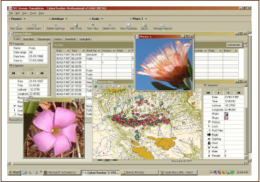
CyberTracker: Free GPS Field Data Collection System
With the launch of their Android version, I became aware of CyberTracker, a free "GPS Field Data Collection System that turns your smartphone into a sophisticated tracking and monitoring device". It's a non-profit organization and they mention free software several times, but not certain that is open source software, anyone knows?
![]()
From the website: "You can use CyberTracker on a Smartphone or handheld computer to record any type of observation. CyberTracker, which requires no programming skills, allows you to customize an Application for your own data collection needs. [...] CyberTracker is the most efficient way to gather large quantities of geo-referenced data for field observations at a speed and level of detail not possible before. Observations can be entered with a simple Radio List or a Check List. Number and text fields can also be entered by means of conventional key pads or keyboards."
Plenty of screenshots here and the list of features.
Batch Geonews: Google Views and 150 New 3D Cities, Future of National Mapping Agencies, Sentinel Imagery Free, and much more
A batch mode edition while on holidays. Next one will be late August since I'll be away from computers (and even without electricity!) for a few weeks.
From the open source / open data front:
- With open source software, you can get Super Sharp 50cm Pléiades Satellite Imagery on MapBox, "Any point on Earth, everyday, with 50cm resolution. With this guide you can go from image download to rendered maps in minutes, all with open software."
- Here's a Digital Trends article named Google Map Maker vs. OpenStreetMap: Which mapping service rules them all?
- With Foursquare direct OpenStreetMap editing, could encourage others to provide the same direct OSM editing (via Mapperz)
- Fiona 1.0 released, "Fiona is OGR's neat, nimble, no tears API", a Python library
- Work continues, OpenLayers 3.0 alpha 4
- Interesting, Why OpenGeo Has Taken on Outside Investment
From the Esri front:
- There's New Developer Subscriptions for ArcGIS Online
- Esri and open source, New Esri Open Source Javascript Projects: Esri-Leaflet, Geoservices.js, Terraformer, Pushlet
- Still competing, Esri and MapBox play well together via Arc2Earth
- More integration with Microsoft too, Esri Maps for SharePoint 3.0 Released!
From the Google front:
- Google is Introducing “Views” - A new way to contribute your 360° photo spheres to Google Maps
- Many will be happy, Google pushing out 3D Imagery at a rapid pace, with about 150 new cities with the 3D imagery
- Not intuitive, What the imagery dates really mean in Google Earth
- Tips on Making high-quality movies with Google Earth
- I have one too and I agree, The SpaceNavigator remains the best way to use Google Earth
A big bunch of geospatial-related news discussed over Slashdot:
- We mentioned a few times GPS spoofing, Students Hijack $80 Million Superyacht With GPS Spoofing
- Autonomous, aka driverless cars, are really getting closer, Full-Size Remote Control Cars
- For 3D printing, Fuel3D Start-Up Promises Affordable Point-and-Shoot 3D Scanner
- And an 'undo', 3D Printing In Gel Enables Freeform Design and an Undo Function
- Privacy again, Fifth Circuit Upholds Warrantless Cellphone Location Tracking
- Privacy in Russia, Moscow Subway To Use Special Devices To Read Data On Passengers' Phones
- And we told you before that RFID isn't safe, Long Range RFID Hacking Tool To Be Released At Black Hat
- Drones in the sky? No, that's underwater drones now, DARPA Hydra: An Unmanned Sub Mothership to Deploy Drones
- Stores too, Retail Stores Plan Elaborate Ways To Track You
- Crowdsourcing the perception of cities via pictures, MIT's "Hot Or Not" Site For Neighborhoods Could Help Shape Cities
- If you feel up to, DIY Satellite Tracking
- To end with a map, A Circular New York City Subway Map To Straighten Things Out
In the everything-else category:
- Geoff shares a summary of the UN report on The future of national mapping agencies over the next 5-10 years - this is a must read even to those not in the governmental sector
- More free imagery, from the Sentinel satellite this time, The European Commission Plans Remote Sensing Satellites and Free Access to their Data
- Apple is looking to improving power management of mobile devices by remembering charging locations and usage patterns
- Interested in contributing to Apple Maps? Apple Filling Out its 'Ground Truth' Mapping Team with New Regional and Local Job Listings
- For your non-geo colleagues, Get to Know a Projection: Mercator
- Here's a 4-minutes video, DigitalGlobe takes a look at the last 50 years of the satellite industry
- An ESA article on watching wetlands from space
In the maps category:
- Cars, Visualizing New York’s Road Accidents With the Interactive ‘Crashmapper’