Supergeo has been improving JavaScript APIs since the first release of SuperGIS Server 3.2 to let developers customize their web applications more flexibly. For example, they can customize info window or dynamically render layers at ease. JavaScript APIs are useful tools for developers to customize their ultra web applications to provide more functionality. In SuperGIS Server 3.2, there are a ...
Read More »Tag Archives: Supergeo
Supergeo Launches the Newest SuperGIS Network Analyst 3.2
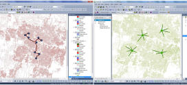
Supergeo Technologies Inc., the global leading GIS software and solution provider, launches the newest SuperGIS Network Analyst 3.2 with stronger analysis performance and computing methods. SuperGIS Network Analyst 3.2 enables users to analyze routing problems in multiple applications, such as transportation planning, tourism shortest analyst, underground pipelines planning, convenience store location deciding, service distribution etc. Through the analysis program, users ...
Read More »Supergeo Awards Reseller of the Year to Helix S.r.l., Italy
Supergeo Technologies, the global leading GIS software and solution provider, announce that Helix S.r.l., Italy is awarded as Supergeo Reseller of the Year for their contribution to creating important client base and brand awareness in the EU. The two companies started to collaborate in when Helix S.r.l. firstly developed mobile GIS program for civil services by SuperGIS Mobile ...
Read More »SuperPad Assists Public Works Planning in Liberia
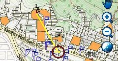
Supergeo Technologies, the global leading GIS software and solution provider, announces that SuperPad assists Ministry of Public Works in Monrovia, Liberia in geospatial data collecting and updating to improve rural regional living conditions. SuperPad 3.1a is the professional mobile GIS and data collection application, specially designed for Windows Mobile devices. It can help field surveyors to easily capture, display, edit, ...
Read More »GIS-powered Vector Mosquito Data Management System to Enhance Public Health
In warm and humid subtropical areas like Southeast Asia, prevention and cure of vector mosquito is a key mission for epidemic and diseases control authorities. To achieve the goal, officers need to establish a system, which should be easy-to-use but also capable to load large data and display it in an understandable way. The authority in Taiwan built the Vector ...
Read More »Latest SuperGIS Desktop 3.2 Enhances Map Display Performance and Analysis Functions
Developed by Supergeo, the latest Desktop GIS, SuperGIS Desktop 3.2 now provides users with a more powerful and comprehensive platform to display and edit GIS data by improving stability, accelerating map display performance and adding more analysis tools. SuperGIS Desktop 3.2 integrates abundant GIS tools to offer users from various domains a professional platform for geoprocessing, analyzing, displaying, editing, managing, ...
Read More »Supergeo to Release Forest Inventory App for Android Users
Forest Inventory App, an Android app designed for forest information collection, developed by Supergeo, will be released to provide forest investigators with a professional and handy tool for field survey and data recording in forests. With this App, natural resource managers can quickly record the required information during field survey and improve task efficiency. Integrating with GIS and GPS technologies, ...
Read More »Mapping and Collecting Geospatial Data with iOS
Supergeo Technologies Inc, the leading global provider of GIS software and solutions, announced that SuperSurv 3.2 (iOS), professional mobile GIS App, supports French user interface and Lebanese coordinate system. The new updates enhance manipulation convenience and provide a powerful GIS survey app. SuperSurv (iOS), GIS data capture app, is designed for geospatial data collection via iPhone and iPad. Integrating with ...
Read More »Smart City Solutions on 3D GIS Platform
Supergeo Technologies is going to bring GIS users a no-cost 3D GIS webinar to solve modern city management problems. The webinar will show how 3D GIS can be applied to building a smart city, and also provide technical supports for publishing GIS services on a 3D globe, simulating to our real-world. From 3D view, the relationships between different geospatial features ...
Read More »India Lingaraj College Selects SuperPad for Precise Data Collection
Supergeo Technologies, a leading global provider of GIS software and solutions, announced that Lingaraj College of K.L.E. Society in India selects SuperPad 3.1a to enhance geospatial data collecting efficiency and encourage non-GIS major students to learn the spatial technologies to apply to their study. K.L.E. Society was founded in 1916 to provide education for the children of farming community ...
Read More »