Tag Archives: GIS

Explore the power of ArcGIS Geodatabase

8648OT_Mockup Normal_0

The geodatabase is the common data storage and management framework for ArcGIS. It combines “geo” (spatial data) with “database” (data repository) to create a central data repository for spatial data storage and management. It can be leveraged in desktop, server, or mobile environments and allows users to store GIS data in a central location for easy access and management. Learning …

Read More »

Avenza Releases MAPublisher 9.5 for Adobe Illustrator

avenza_logo_200px

- Cartographic add-on now compatible with Adobe Illustrator Creative Cloud™ - Toronto, ON, July 9 - Avenza Systems Inc., producers of the PDF Maps app for mobile and geospatial plug-ins for Adobe Creative Cloud, including Geographic Imager for Adobe Photoshop®, is pleased to announce the release of MAPublisher 9.5 for Adobe Illustrator. This latest update includes many new features …

Read More »

QGIS 2.4.0 Released

Formerly known as Quantum GIS, QGIS is one of the most mature open source desktop GIS software. Over the weekend, QGIS 2.4.0 has been released and here’s the visual changelog. From the visual changelog’s introduction: “The emphasis on this release has been very much on polish and performance - we have added many new features, tweaks and enhancements to make …

Read More »

ThinkGeo Releases Map Suite 8.0 with Centralized Product Center for Easy Product Access, Native Support of Popular Data Formats, and Many Other New Features

Frisco, TX - ThinkGeo has released version 8.0 of Map Suite, its full line of GIS software components for .NET developers. This major milestone refreshes ThinkGeo’s entire product line with a wide variety of enhancements.  It includes a new delivery mechanism for the Map Suite family of products, new natively supported data formats, enhancements, bug fixes and stability improvements.   …

Read More »

What are Earth Observation and Remote Sensing Jobs?

Earth Observation Directory (EOD) provides worldwide job positions related to Earth Observation and Remote Sensing since more than a year and it recently announced an detailed analysis of all their job opportunities.

In which country you can find the most of opportunities? Which skills are the most commonly required? And, what about salary expectations? These are some of the questions, which they wanted to answer. As a result, they set up an interesting profile of the Remote Sensing & GIS Specialist. For example, it shows that most of opportunities are provided by governmental institutions like universities and research laboratories. Moreover, it highlights that besides usual GIS software abilities, language programming is more and more required.

Read More »

Supergeo Establish User Network with Evolving Geosystems in UAE

Supergeo Technologies, a leading global provider of GIS software and solutions, announces the official reseller agreement with Evolving Geosystems Technologies (EGT) to keep providing high-quality total SuperGIS solutions in UAE.


Located in Dubai, EGT provides sophisticated GIS solutions, analysis, turnkey systems, custom applications, and technical support for government sectors, higher educational institutes, and the enterprises focusing on oil and gas, utilities, defense, etc. The professional team at EGT can assist different groups in making better decisions with the abundant functions in SuperGIS.


Focusing on state of the art GIS technologies, Supergeo provides total GIS solutions which includes desktop, mobile, server and engine for general users and GIS developers. No matter project managers, GIS analysts, field surveyors or even non-GIS domain users, SuperGIS software’s user-friendly interface and powerful functionality are to maximize efficiency and minimize the costs.


SuperGIS comprehensive solutions have been used worldwide to meet the challenges and requests in diverse domains. The further collaboration with Middle Eastern enterprise, Evolving Geosystems Technologies, also encourages Supergeo to support advanced GIS for organizations and professionals in UAE.


#  #  #


About Supergeo


Supergeo Technologies Inc. is a leading global provider of GIS software and solutions. Since the establishment, Supergeo has been dedicated to providing state-of-the-art geospatial technologies and comprehensive services for customers around the world. It is our vision to help users utilize geospatial technologies to create a better world.

Supergeo software and applications have been spread over the world to be the backbone of the world’s mapping and spatial analysis. Supergeo is the professional GIS vendor, providing GIS-related users with complete GIS solutions for desktop, mobile, server, and Internet platforms.


Read More »

Avenza Releases MAPublisher 9.4 for Adobe Illustrator

- Enhanced cartography tools to create high-quality maps made even easier -

Toronto, ON, May 5 - Avenza Systems Inc., producers of the PDF Maps app for mobile and geospatial plugins for Adobe Creative Suite, including Geographic Imager for Adobe Photoshop, is pleased to announce the release of MAPublisher 9.4 for Adobe Illustrator. This latest update includes new many features including streamlined import, support for additional formats when exporting a document to web tiles, and a new image attribute type to support images imported from the PDF Maps app on both iOS and Android platforms.

"We’re excited to release MAPublisher 9.4 because of its continued evolution to make it even easier to create great looking maps with enhanced cartography tools,” said Ted Florence, President of Avenza. “The enhancements and features in this release have been developed from customer feedback with significant improvements to import and export interoperability. The primary focus of this release is to increase productivity for cartographers and GIS professionals by enabling them to easily and quickly import data, create high-quality map products, and easily publish or export to print and digital formats,” he added.

Enhancements and new features of MAPublisher 9.4

  • Streamlined data import: Import (formerly Simple Import) and Multiple Data Import (formerly known as Advanced Import). Improved interface provides additional coordinate system information and easier access to format specific Adobe Illustrator options that affect how data is imported.
  • New image attribute type to store an image for each record in a layer's MAP Attribute table. Image attributes are supported when importing from the PDF Maps app (in KMZ format) and exporting to Google Earth (in KMZ format).
  • Export Document to Web Tiles now supports MapBox and Tile Map Service map providers. A new anti-aliasing option to optimize art or type is now available.
  • New ability to export a coordinate system file for non-geospatial image formats.
  • New ability to specify grid constraints to limit the geographical extent of a Measured Grid. In addition, a new option is available for ticks to follow the line at the grid boundary.
  • New file export option to assign metadata for TAB/MIF and KML/KMZ formats. The metadata assignment option allows layer attributes to be assigned to format specific metadata fields.
  • Improved preview quality makes it easier to see how settings affect the scale bar.
  • Newly designed MAP Layer icons and feature type icons.
  • Various user interface and performance enhancements to improve usability.


More about MAPublisher for Adobe Illustrator

MAPublisher for Adobe Illustrator is powerful map production software for creating cartographic-quality maps from GIS data. MAPublisher tools leverage the superior graphics design capabilities of Adobe Illustrator to manipulate GIS data and to produce high-quality maps with accuracy and efficiency.

MAPublisher 9.4 for Adobe Illustrator is available free of charge to all MAPublisher users with an active maintenance subscription and as an upgrade for non-maintenance users at US$599. New licenses start at US$1399. MAPublisher FME Auto and MAPublisher LabelPro are also available as add-ons to MAPublisher 9.4 at prices starting at US$399 per license. Academic, floating and volume pricing are also available. Prices include one year of full maintenance.

More about Avenza Systems Inc.

Avenza Systems Inc. is an award-winning, privately held corporation that provides cartographers and GIS professionals with powerful software tools to make better maps. In addition to software offerings for Mac and Windows users, Avenza offers value-added data sets, product training and consulting services, as well as the PDF Maps app for purchasing and using maps on iPhones, iPads and iPod Touch devices.


Read More »

Android-Powered Mobile GIS, SuperSurv 3.1a, Supports Auto Positioning

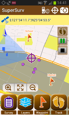
Supergeo Technologies, a leading global provider of GIS software and solutions, announces that SuperSurv 3.1a for Android, the data collection app, now supports Auto Positioning to provide users with a more convenient and intuitive manipulation.


SuperSurv 3.1a is the mobile GIS app designed for field survey. The Android-powered app integrates with GIS and GPS technologies and provides rich functions like Map Display, Query, Measure, etc, for field surveying. In offline mode, users may edit and save point, line and polygon data directly with GPS. Going online, users may apply online maps and synchronize data in the server side.


To improve field survey performance, SuperSurv 3.1a now comes with Auto Positioning function. Through the new function, users can have map and GPS position refreshed automatically while moving with a certain distance in the field, such as GPS tracklog recording.


In this way, the map in SuperSurv can be refreshed with the GPS position remaining in the map center, allowing users to easily comprehend their position without manually panning maps all the time, significantly increasing the user friendliness and convenience.


On the other hand, to provide complete mobile solutions for iPad and iPhone users, SuperSurv for iOS is also available on the App Store. In addition, especially designed for the users in North America, SuperSurv M3 edition is now on the Google Play and App Store, for the surveyors looking for basic but necessary GIS functions for field survey.


#  #  #


About Supergeo


Supergeo Technologies Inc. is a leading global provider of GIS software and solutions. Since the establishment, Supergeo has been dedicated to providing state-of-the-art geospatial technologies and comprehensive services for customers around the world. It is our vision to help users utilize geospatial technologies to create a better world.

Supergeo software and applications have been spread over the world to be the backbone of the world’s mapping and spatial analysis. Supergeo is the professional GIS vendor, providing GIS-related users with complete GIS solutions for desktop, mobile, server, and Internet platforms.


Read More »

SuperGIS Desktop Assists Geo-Sol, South Africa, in Efficient GIS Processing

Supergeo Technologies, a leading global provider of GIS software and solutions, announces that Geo-Sol, South Africa chooses SuperGIS Desktop 3.2 for high-efficiency GIS data processing and spatial analyses for earth and soil applications.


Based in Ladysmith, South Africa, Geo-Sol is a professional civil earth testing company which serves various earth related services, including geotechnical investigations, soil and rock aggregate analysis, water quality testing, soil report datasets and concrete strength analysis. Through the recommendation from Spatial Perspective company, Geo-Sol utilized SuperGIS Desktop 3.2 for processing large soil data for further geospatial analysis and applications.


SuperGIS Desktop 3.2 is the full-function GIS software which offers practical GIS tools and abundant analyst extensions for all GIS users. It can create, edit, identify, manage, and analyze geospatial data and visualize the data with maps in an accurate way. The support of different GIS data formats and geodatabases makes the information exchange more convenient and the work more efficient.


Supergeo provides comprehensive GIS software and solutions which can well enhance the spatial data processing and bring better data quality. Choosing by the South African civil and earth testing specialty also indicates that SuperGIS is internationally reliable, and also further motivates Supergeo to provide a superior service for global users.


#  #  #


About Supergeo


Supergeo Technologies Inc. is a leading global provider of GIS software and solutions. Since the establishment, Supergeo has been dedicated to providing state-of-the-art geospatial technologies and comprehensive services for customers around the world. It is our vision to help users utilize geospatial technologies to create a better world.

Supergeo software and applications have been spread over the world to be the backbone of the world’s mapping and spatial analysis. Supergeo is the professional GIS vendor, providing GIS-related users with complete GIS solutions for desktop, mobile, server, and Internet platforms.


Read More »

Supergeo Extends Platinum Partnership with Helix S.r.l. in Italy

Supergeo Technologies, a leading global provider of GIS software and solutions, announce the renewed partnership with Helix S.r.l., Italy, for assisting more Italian and European users in professional GIS applications.


Helix S.r.l. has provided professional GIS solutions for almost a decade. Its service range crosses various areas, including civil protection safety, land management, geospatial consulting and training. In addition to local government users, Helix S.r.l. also provides private companies and public administration, such as University of Camerino and ASA SpA, with comprehensive solutions.


As the Platinum partner of Supergeo, Helix S.r.l. has helped to expand Superego’s coverage to whole Italy. The abundant functions of SuperGIS software can not only perfectly fulfill the huge data processing demand, but also provide users with friendly interface to save time and make efficient spatial decisions.


With the renewed partnership, Supergeo looks forward to seeing a better and more accurate geospatial data service for Italian and other European users. Helix’s high-quality service can also support Supergeo with a greater international vision to optimize products. The collaboration will doubtlessly bring the market and users the superior GIS choice.


std/image.jpg


#  #  #


About Supergeo


Supergeo Technologies Inc. is a leading global provider of GIS software and solutions. Since the establishment, Supergeo has been dedicated to providing state-of-the-art geospatial technologies and comprehensive services for customers around the world. It is our vision to help users utilize geospatial technologies to create a better world.

Supergeo software and applications have been spread over the world to be the backbone of the world’s mapping and spatial analysis. Supergeo is the professional GIS vendor, providing GIS-related users with complete GIS solutions for desktop, mobile, server, and Internet platforms.


Read More »