Recent Posts

MapGuide Open Source 2.5 Released

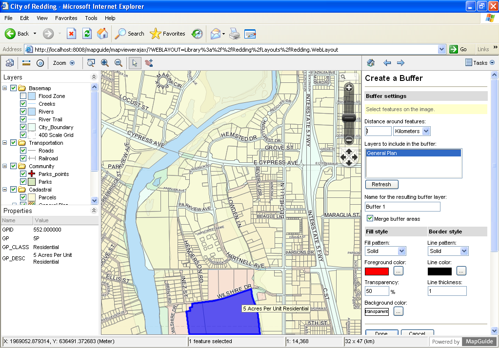
After v2.4 last fall, MapGuide Open Source 2.5 has been released. Can anyone share thoughts or links regarding MapGuide's user community? Is it still vibrant as it used to be?

Major new items from the release notes: "

  • PDF-based QuickPlot? for Fusion (RFC 124)
  • Google Street View widget for Fusion (RFC 125)
  • Support for user coordinate system dictionaries (RFC 127)
  • Integrated IDE API documentation support for Java/.net (RFC 129)
  • New enhanced Java wrapper API (RFC 129)
  • Streamed HTTP feature/data/SQL query results (RFC 130)
  • Various AJAX Viewer UI and functionality improvements
  • Enhanced Redlining widget with expanded data format support  more info
  • Fixes and enhancements to assorted Fusion widgets and templates  more info"

OpenSignal: Global Map of Cellular Coverage

Via Google I learned about OpenSignal, which provides a cellular signal coverage map.

From their about page: "With your help, we're creating a comprehensive database of cell phone towers, cell phone signal strength readings, and Wi-Fi access points around the world. Our goal is to become the global authority on wireless networks. On this website we provide visualizations and analysis based on the data we've collected, including cellular coverage maps that show exactly how strong signal is in any particular area, as well as all the nearby towers for your carrier. […] In return for users submitting their signal strength data, we pledge to generate a coverage map and make it available for anyone around the world to view, for free, at any time!"

However, its data is not open like the OpenCellID project we mentioned in.

Open Source Geonews: OpenStreetMap iD Map Editor Beta 1, EuroGlobalMap, GeoServer Beginner’s Guide, and much more

Here's the recent open source / open data geonews in batch mode.

Software-related:

  • On the iD Map Editor, the new OpenStreetMap editor, reached the Beta 1 state, if you want to see it in action, here's a nice 1-minute video
  • It was mentioned in our press release section, but deserves additional attention, "GeoServer Beginner's Guide is a new book from Packt that teaches the readers to build custom maps using the dynamic real-time geospatial information. With the help of this book, readers will learn sharing of real-time maps quickly" Here's Jody's review of the book
  • Via OR I learned about the release of Titan 0.3 which supports georeferenced data: "Titan is a highly scalable graph database optimized for storing and querying large graphs with billions of vertices and edges distributed across a multi-machine cluster. Titan is a transactional database that can support thousands of concurrent users."
  • Here's about Scribe - A tool to facilitate the creation of Maps with MapServer
  • Via OR, here's the code for WebGL Heatmap "a JavaScript library for high performance heatmap display"
  • An open source Desktop GIS we never mentioned before, VSceneGIS Desktop v0.9.5, which seems to have only Spanish documentation
  • Interested by the desktop GIS uDig? Here's a course on geographic scripting in uDig
  • Amongst other updates, New final version of i3Geo available: i3Geo 4.7 and deegree 3.2.0 webservices released
  • You can't wait? Here's Some cool new features in the upcoming QGIS 2.0
  • And yes, OpenLayers 3 is getting closer to reality, the latest code sprint summary

Open data:

  • Related to OpenStreetMap, the LearnOSM website got a major facelift and there's OSM PLUS - the OpenStreetMap Commercial Users Summit, the first meeting to occur on June 10th in San Francisco… with Garmin being another of the major companies diving into OpenStreetMap
  • Geoff tells us about EuroGlobalMap, a free and open authoritative European geospatial data site
  • The City of Chicago now offers its data on GitHub, most of it being georeferenced: "This is a new experiment, where we can see if it’s possible to crowdsource better data. GitHub provides the necessary functionality."
  • On the topic of open data, you can read the new entry named The Flawed Economics of Closed Government Data by Brian Timoney

Everything else:

  • Here's an entry on Map overlays with WebGL: affine, polynomial, TPS transformations in JavaScript with GLSL
  • There's a new Open Source Geospatial Laboratory established at the University of Warwick, UK
  • Here's the Keynote speakers at FOSS4G-CEE

Esri Geonews: Numerous ArcGIS Online Updates, Esri Maps for Office 2.0 Released, and more

Here's the recent Esri-related geonews in batch mode.

From official sources:

  • Here's a list of What’s New in ArcGIS Online for March, a lot of new features
  • There's also new data, DigitalGlobe and community imagery added to the World Imagery map and new updates to the Ocean Basemap
  • Crowdsourcing works for Esri too, New community contributions added to the World Topographic Map and a second entry on the same topic and other contributions
  • Other related additions include using Bing basemaps in ArcGIS Online and using Stamen and MapBox tilesets as basemaps in ArcGIS
  • Here's the announcement of Esri Maps for Office 2.0 Released: "Esri Maps for Office is a powerful add-in for Microsoft Office that brings the capabilities of Esri’s mapping platform to Microsoft Excel and Microsoft PowerPoint users."
  • Amongst updates, ArcGIS API for JavaScript Version 3.4 Released and if Flex is not dead for you, ArcGIS for Flex 3.2 Released
  • Three new beta SDK available: ArcGIS Runtime SDK for Windows Store apps Beta is available, the ArcGIS Runtime SDK for Qt 10.2 beta is now available and the new ArcGIS Runtime SDK for OS X Beta is available
  • And if the ArcGIS Runtime SDK for iOS is of interest to you, there's the MapKit 2 ArcGIS Project on GitHub

From other sources:

  • Directions Mag offers an article named Esri Certification Exams - Are you ready?

Google Geonews: Google Maps Engine Lite Launched, User Testing of Google Glass Started, and much more

Here's the recent Google-related geonews.

From official sources:

  • A new mapping tool offered by Google, Create, collaborate and share advanced custom maps with Google Maps Engine Lite (Beta): "Of course, experts aren’t the only ones who love to make maps. Today we're launching Google Maps Engine Lite (Beta), so any mapping enthusiast can now create and share robust custom maps using this powerful, easy-to-use tool. You can import small spreadsheets of locations onto a comprehensive map, visualize those places through a variety of styling and drawing options, and organize and compare up to three different data sets for your non-business purposes." For those who don't remember, 'Google Maps Engine' is the new name of what was known as 'Google Earth Builder'.

  • Google also started looking for Explorers to test drive Google Glass, which we will definitely hear often about in the coming months - Slashdot discusses Google Glass in three discussions: Lawmakers Seek To Ban Google Glass On the Road, Should We Be Afraid of Google Glass? and Google Glass and Surveillance Culture
  • There's Live transit information in more cities on Google Maps: "live departure times for seven lines on the New York City subway system (MTA), as well as for buses and trams in the greater Salt Lake City area (UTA). With these updates – part of the millions of live transit schedule updates we process every day – you get instant access to the latest information right on Google Maps, making trip planning a cinch."
  • Google released Imagery on Google Maps of Fukushima Exclusion Zone Town Namie-machi also discussed over Slashdot in a story named Google Releases Street View Images From Fukushima Ghost Town
  • If there's a Pirate in you, or you have kids, you might be interested in Finding treasures with Google Maps, related, here's about Teaching about the ocean floor with Google Earth
  • Google invites us to Explore Everest, Kilimanjaro and more with Google Maps
  • If you're a non-profit organization, you might be interested in making a map that will change the world with Google Earth Outreach Developer Grants
  • Other minor official entries include: Google Maps shows Amazon funds at work, Trekker takes on Canada’s Arctic Winter and A behind-the-scenes look at our latest Google Maps special collection

From other sources:

  • The GEB has a short entry on Managing KML and KMZ files on mobile devices
  • What used to require a GIS, here's about Using Google Earth terrain data to plan wireless networks
  • APB share links about Google Indoor Mapping: Does it Work? WIll it Save Brick and Mortar Retail from Web Competitors?
  • APB also shares an entry on Queensland Putting its Data On Google Earth
  • Guess what, there was new imagery to Google Earth a bit less than 2 weeks ago, other minor stories from the GEB includes Researchers rediscover lost butterfly species with the help of Google Earth, Race Formula One tracks with Google Earth and An in-depth look at the history of Street View