Tag Archives: Bing Maps

Batch Geonews: Shapefiles in Bing Maps, 80% of Data is Not Spatial?, In-Location Alliance, ArcGIS for AutoCAD 300, and much more

This is my tentative to catch up the geonews since my mid-August holidays. Here they are!

On the open source / open data front:

  • UDig 1.3.2 has been released with several new features and supports Axios spatial editing tools again
  • Since the USGS provides the Landsat archive, but this entry mentions that a substantial part of the Landsat archive is available on the fast and reliable public Google Earth Engine cloud storage

On the Esri front:

  • The free plugin ArcGIS for AutoCAD version 300 is now available
  • There's now an ArcGIS Runtime for iOS for ArcGIS WebMaps

On the Google front:

  • Google made a few Google Maps announcements, including voice guided directions in India, Map Maker in New Zealand and new Street View in 150 university campuses
  • In another entry, Google offers a roundup of their August Google Maps related news, most news we already shared with our users
  • Nothing surprising, new imagery released on September 1

On the Microsoft front:

  • Microsoft shares an entry on overlaying Esri shapefiles in BIng Maps
  • Microsoft's Global Ortho Project is complete for the United States, meaning there's high resolution 30cm imagery everywhere in the country
  • There's a new Bing Get Me There App for iOS for London, UK
  • An entry on Bing Maps V7 AJAX Highlights

In the everything else category:

  • James shares a must-read short entry named '80% of Data Is Not Spatial So Stop Claiming It Is', read the comments for insights
  • Here's a pertinent entry related to a UN paper, Criticism - Future Trends in Geospatial Information Management: The Five to Ten Year Vision
  • Here's an update on the OGC standards and the semantic web (aka Linked Data)
  • APB informs us that 22 companies formed the In-Location Alliance to Enhance Indoor Positioning
  • O'Reilly links to an article on Yelp Checkins to Measure Geopositioning Accuracy Across Phones
  • Slashdot discuss the Location Privacy Act Approved By California Legislature
  • Other stories at Slashdot, The Rapid Rise of License Plate Readers and UK License Plate Cameras Have "Gaps In Coverage"
  • Big numbers, APB indicates that the GIS market will soon reach between 3.7 - 10.6 Billions, depending on who you ask

In the maps category:

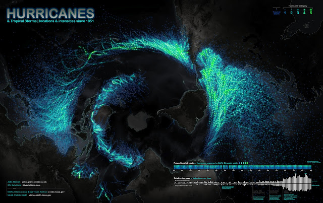
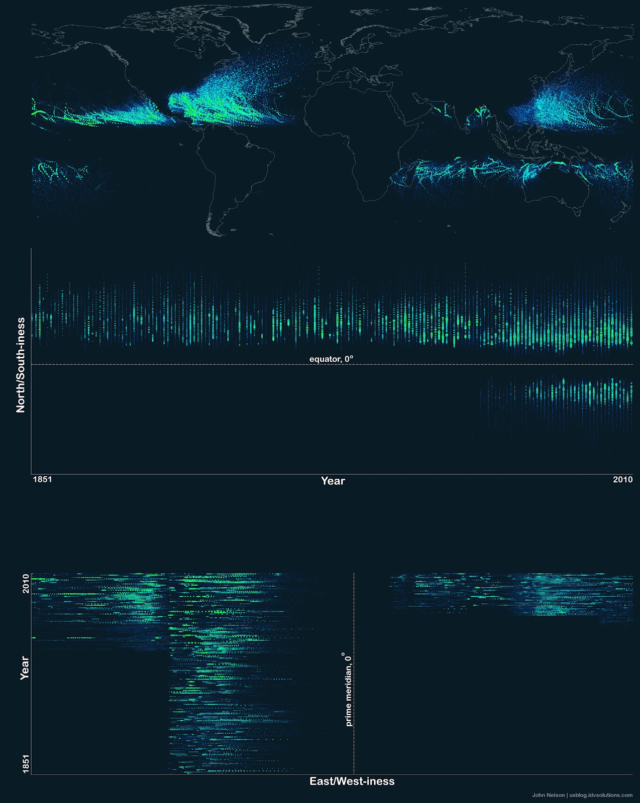
  • On APoD, there's a pretty interesting map of hurricane and tropical storms paths (screenshot below)
  • An interesting map of the Global Decline in Religiosity
  • Some London Olympics maps: The politics of London Olympic medal counts

Read More »

Batch Geonews: OpenStreetView, 215TB of new Bird’s Eye Imagery, Omnipresence of the Google Maps API, and more

Here's the recent geonews in batch mode. It excludes Esri-related geonews since I wait for the conclusion of the User Conference to share an aggregated entry. Also to note, this week some of our users finally get our daily newsletter in their inboxes after an absence of over a year - the problem was that it was identified as 'spam' by a 3rd party filtering system - thanks to the user who reported this issue!

On the open source front:

  • It's in a James Fee rant named Google Maps Is More Accurate Because They Say It Is, I learned about the OpenStreetView, you guessed it, an open version of Google's Street View
  • A few weeks ago, we mentioned FOSS4G in Beijing being cancelled, here's the related official OSGeo board reaction
  • Here's an entry on Creating contour lines with GDAL and Mapnik
  • A technical entry named Manipulating GPS tracks in Spatialite
  • Time flies, QGIS Is Ten Years Old

On the Microsoft front:

  • Microsoft released an impressive 215TB of new Bird's Eye imagery: "spans across the United States and features certain areas in Europe, Australia, New Zealand and Tokyo"
  • In an entry, Microsoft details the Bing Maps keys, including the limitations of what you can do for free

Discussed over Slashdot:

  • Dr. Faragher Answers Your Questions About the Future of Navigation Technology, he's the Principal Scientist at the BAE Systems Advanced Technology Centre and NAVSOP supporter
  • A discussion on Resources For Identifying Telecom Right-of-Way Locations?
  • Australian Consumer Group Wants Geo-IP Blocking Banned "saying it created significant barriers to the free flow of goods and services"
  • Samsung Galaxy S3 Stripped of Local Search

In the miscellaneous category:

  • Pretty interesting stat: 93% of the top million sites and 89% of the top 10,000 sites on the internet with maps are using Google maps or the Google maps API, this comes from this overview of statistics for mapping technologies
  • Directions Mag offers screenshots in an entry named Get Ready for the London Olympics with AEgis’ 3D Models
  • Via the AQT [French link], I learned about the Kessler syndrome: "[...] a scenario in which the density of objects in low Earth orbit (LEO) is high enough that collisions between objects could cause a cascade – each collision generating debris which increases the likelihood of further collisions. One implication is that the distribution of debris in orbit could render space exploration, and even the use of satellites, unfeasible for many generations."
  • APB tells us that DigitalGlobe and GeoEye agreed to merge
  • APB informs us that there is Nokia 4000 Indoor Maps
  • Apparently, drones are an hazard to air traffic in Somalia
  • The GEB has en entry on Meograph, as multimedia tool for creating Google Earth visualizations
  • Long entry on MapQuest iOS Maps API 1.0.1 released and their official announcement of their iOS Maps API
  • The US NGA released its Strategic Plan-2017
  • An interesting short entry, Starbucks: 1 Store = $1 Million Investment and GIS Helps Get It Right

In the maps category:

  • Via O'Reilly, you can read Google's Ed Parson in an short article named The Future of the Map Isn't a Map at All—It's Information
  • TMR shares an entry about Susan Schulten's 'Mapping the Nation' book, focusing on 19th century U.S.

165TB of New Imagery Added to Bing Maps

We don't usually make much noise when there is new imagery is provided, but in that case, Microsoft announced Monday 165TB of New Imagery Added to Bing Maps.

From the entry: "Today we’re thrilled to announce the publication of our largest satellite release to date. In fact, this release is larger than all of our past Aerial releases combined! The latest Aerial release includes new Satellite imagery as well as Global Ortho photography. Both releases total 165 terabytes of new data live on Bing Maps. Prior to this, our existing Aerial footprint was 129 terabytes total."

Follow the link to see several screenshots.

Read More »

Batch Geonews: GeoExplorer, Google vs Apple Maps, Unmanned Aerial Systems, London Olympics, Tornadoes, and more

Here's the recent geonews in batch mode.

From the open source front:

  • OpenGeo runs an entry named Five things you didn’t know about GeoExplorer

From the major companies front:

  • I liked the Google vs Apple mapping discussion from Peter Batty: "Google announces that it is scared of Apple Maps
    [...] Now don't get me wrong, Google is the market leader and Apple has everything to prove."
    See also his entry named Apple Maps: Predictions and Questions, which are also of course innovations Google could implement. Viva competition! (well ok, I admit I prefer cooperation ;-)
  • James has an interesting entry named One Man's Disruptor is Another Man's Incumbent, the incumbents are Google Maps, MapQuest, Esri and Microsoft, and the disruptors are MapBox, Esri and Apple
  • Via O'Reilly, the connection between Google Street View and driverless cars: "Now, I’m realizing the biggest Street View data coup of all: those vehicles are gathering the ultimate training set for driverless cars." Read the comments, driverless cars data is not simple
  • There's 2 new modules for Bing Maps V7: GeoJSON and WKT reader/writer modules
  • The GEB discusses Using StreetView to validate 3D models

Discussed over Slashdot:

  • NASA Tool Shows Where Forest Is Being Cut Down
  • Autralian Mining Companies Increasing Use of UAVs
  • Cognitive Software Identifies America's Brainiest Cities
  • John Carmack Is Building a Virtual Reality Headset
  • Trained Rats Map Minefields With GPS

In the everything-else category:

  • The eoPortal shares an entry named US not losing its foothold in Earth observing satellites, only shifting power
  • The eoPortal also mentions a new imaging system produces 3D models of monuments using unmanned aircraft
  • On that very topic, DM shares an article named Ten Things You Should Know About Unmanned Aerial Systems (UAS)
  • VerySpatial have an informative entry on geospatial at the upcoming London Summer Olympics and U.K. in general
  • AR as entertainment of the future? Kinect and RFID power an augmented reality theme park (via OR)

In the maps category:

  • Here's a nice visualization of 56 years of tornadoes in the U.S.

As a bonus for reading till the end, here's a interesting quote: "If a picture is worth a thousand words, a map can be worth a thousand spreadsheets."

Read More »

Batch Geonews: StreetView in Jerusalem, Broadcom 4752 Location Chip, GIS Certification, Mapping Ice Shelf Disintegration, and much more

Here's the recent geonews in batch mode.

From the open source front:

  • Here's a DM summary entry on FOSS4G-NA that I haven't shared yet, and it's pretty informative
  • There's a new video showing us uDig features
  • Here's examples of using QGIS in local government, related to QGIS, here's an entry on What's New in QGIS Plugins
  • A technical entry on dynamic WMS styling with GeoServer with SLD
  • Here's an interesting web browser memory usage experiment for OpenLayers

From the Google front:

  • Google announce new StreetView imagery for Israel in an entry named Exploring Jerusalem’s Old City streets with Street View
  • There's also an update to the Google Maps API deprecation policy and Terms of Service
  • The GEB reminds us the options we have for Sharing your favorite locations in Google Earth

On the Microsoft front:

  • You can now Find Venue Maps, Businesses and Buildings Faster on Bing Maps
  • Bing Maps is Reducing the Complexity of Rendering Shapes

Discussed over Slashdot:

  • A "Big Brother Chip", the Broadcom 4752, that acts as a ubiquitous location chip using everything available: "global navigation satellites, cell phone towers, and Wi-Fi hot spots, coupled with input from gyroscopes, accelerometers, step counters, and altimeters"
  • A GPS system that will speed up tsunami warnings
  • The Physical Travelling Salesman Challenge
  • Using satellite imagery to counting Emperor Penguins from space

Directions Mag articles of note:

  • The Top 10 Things You Should Know about GIS Certification, including "In, more than 5,000 people are active GISPs." and "Eight states have recognized and endorsed the GISP"
  • A Q&A entry about Is Intergraph’s New GeoMedia Smart Client for You?

In the everything else category:

  • The ESA mentions Envisat's mapping of ice shelf disintegration in Antarctic and update on the investigation of Envisat woes, being offline since early April
  • @Thierry_G links to interesting impressions on the Where conference titled From Where 2.0 To Just Where; With Meh 2.0 Somewhere In The Middle, asking where is the geospatial excitement today?
  • Via Paul I found this extreme video example of augmented reality
  • APB has an entry on TomTom’s New Global Geocoder Targets Power Users
  • SS shares a perspective named Have the geospatial technology frontiers changed much in three years?
  • SS also shares an interesting summary of a session on capacity building and the expansion of the global geospatial marketplace to a billion plus people

In the maps category:

  • O'Reilly shares two visualizations, one on The history of shipping routes and the other on Mapping the Titanic's passengers
Read More »

Batch Geonews: GDAL Virtual Formats, Google Map Maker in France, Esri File Geodatabase API 1.2, Bing Maps New Look, and much much more

Here's the recent geonews in batch mode. Again an unusually long edition.

From the open source and open data front:

  • Here's two entries on PostGIS 2.0 new features; Typmod and 3D/4D indexing
  • You might be interested in learning about GDAL virtual formats if you don't use them already, related to GDAL, here's how to correctly compute the average aspect of a DEM using gdaldem
  • There's a Natural Earth Quick Start Kit that includes a QGIS project file, and another entry on adding custom global projections to QGIS
  • There's new 2.5 meters imagery of Australia available for OpenStreetMap
  • O'Reilly shares a story of another company, StreetEasy, switching to OpenStreetMap data
  • In Russia too, with Yandex, they are using crowdsourced maps now
  • If you plan to use MapServer as a WFS 1.1.0 client, read this, since apparently it's support is not optimal just yet

From the Esri front:

  • Via James, the File Geodatabase API 1.2 has been released and MacOS X is now supported
  • About two weeks ago, the ArcGIS 10 Service Pack 4 became available for download

From the Google front:

  • Google just introduced more detailed 3D landmarks on Google Maps, take a quick look at the screenshots included
  • Google Map Maker is now available in France and Monaco
  • You can now get Traffic Conditions in Norway, New Zealand, and Hong Kong
  • Ogle Earth offers a detailed entry on conspiracy, Google Earth and the latest war in Sri Lanka
  • There's a whole new website for Google Maps API Developers
  • The GEB offers an entry on Integrating Street View with the Google Earth Diorama
  • Oh, and there's new imagery

From the Microsoft front:

  • Bing Maps offers a new look for Pushpins, Popups, and Transit
  • And Microsoft announced Bing Maps for Metro Style Apps
  • There's new official Bing Maps forums too

In the miscellaneous category:

  • APB shares an entry named Facebook Outlines Vision for Location APIs
  • O'Reilly shares a story about the impacts of languages on place and location aware tools
  • James informs us that iOS is now telling us when an app is using a geofence
  • Slashdot discussed a story named Stolen iPad's Reported Location Not Enough To Warrant Search, Say Dutch Police
  • Another story on the same site is entitled Pentagon Wants Disposable War Satellites
  • Still from Slashdot, a story named Satellites Expose 8,000 Years of Civilization
  • And a last one from the same source is named DIY Augmented Reality Heads-Up Display
  • Yes, it's been already 10 years of Envisat
  • Here's a Q&A on OGC's CityGML standard
  • Nokia Drive 2.0 offers interesting features such as offline directions, for Lumia Windows Phones

In the maps category:

  • SS shared an entry named New Mapping Tool Shows Potential Radiation Impacts in the United States
  • For the astronomers amongst us, TMR shares a Geologic Map of Io and an Atlas of the Galilean Satellites
Read More »

A Cool Mashup of Google Maps + Google Earth + Yahoo Maps + Bing Maps


A lot of Maps applications are being developed recently. Each with its pros and cons, I recently wrote an article that compares Google Maps VS Bing Maps. People seem to like it.

So the Punch line, I decided to create a cool mashup that combines 4 Maps applications,

  1. Google Maps
  2. Google Earth
  3. Bing Maps
  4. Yahoo Maps

When you zoom or pan in Google Maps ALL 4 Maps are getting updated instantly!

Click here for the Tool


Read More »

wheredat - A simple, easy to use, geocoding interface for web applications

wheredat provides a geocoding and reverse geocoding interface (UI) through Bing maps. You setup an instance of the application and then embed it in an iframe on any other applications that use it. The client app passes an address or lonlat it needs geocoded and wheredat builds a map showing the location found allowing the user to move the point on the map to further refine the location. All this information is passed back to the client app so it can be used or stored there.  wheredat is extremely light weight and quick to load.

Read More »

Batch Geonews: 180,000 Free OrbView-3 Scenes, Car AR Driving, PostGISonline, Bing Maps Updates, Autodesk and Pitney Bowes Alliance, Obesity and Car Travel, and much much more

​This batch mode edition is unusually long. It covers the past month and a bit more. Yes, that's way too much and I won't try to repeat the experience ;-) Here's what I considered pertinent enough to share with you. Exceptionally, in some cases I haven't gave attribution to the source of the news, thank you for your comprehension.

On the geospatial open source front:

  • I just recently became aware of PostGISonline, a site for testing and learning spatial SQL
  • You can now create and manipulate SLD (the OGC Styled Layer Descriptor standard) in Python with python-sld
  • Via the AGISRS list, I learned about OpenQuake, for calculating seismic hazard and risk at any scale, which of course ingest geospatial data and outputs maps
  • Here's WherePost.ca, which crowdsources the location of mailboxes and post offices for Canada
  • Here's the Switch2OSM website promoting OpenStreetMap, OpenStreetMap might go indoor too
  • Still on the OSM topic, V1 shares an entry on the use of OpenStreetMap data in agriculture
  • Here's an entry on the future of GeoCouch and CouchDB
  • GeoServer gets database-level security
  • There's now a plugin to run Python scripts in QGIS
  • Here's about improvements to the QGIS rule-based rendering
  • On a similar topic, here's a guide to beautiful reliefs in QGIS
  • Did you know you can add Google Maps, OSM, and Bing Maps directly in QGIS? You can via the OpenLayers plugin - hey, there's even a Profile plugin
  • There's an updated book published by Gary Sherman, now named The Geospatial Desktop , subtitled Open source GIS and mapping
  • GEOS 3.3.2 has been released

On the Esri front:

  • Mandown shares how to convert GPX files to Features using ArcGIS 10
  • From the same source, Learn The Basics Of Working With The ArcGIS Runtime SDK For Android
  • There were updates to ArcGIS for SharePoint, ArcGIS Mobile and to the ArcGIS API for Windows Phone
  • James and SS talks about ArcGIS Online as the Esri Content Management System

On the Microsoft front:

  • Microsoft announced a few new Bing Maps features, such as traffic incidents and find near route
  • They announced the Bing Maps Windows Presentation Foundation (WPF) Control v1
  • There's new Bing Maps V7 modules too along with a new routing engine
  • James Fee shares an interesting entry named Bing Maps gets Nokia Brand and Possibly the Boot

On the remote sensing front:

  • This is pretty interesting to many: SS shares an entry named USGS Now Offers OrbView-3 High-Resolution Images for Free, 180,000 scenes at 1m spatial resolution available
  • China launched their first high-resolution remote sensing satellite, Ziyuan I-02C
  • Slashdot discussed the newly released version of Blue Marble high definition (and beautiful) satellite image of the Earth from the Suomi NPP satellite
  • Slashdot is running a story named Who's Flying Those Drones? FAA Won't Say and related, O'Reilly mentions OpenPilot, open source UAV with cameras
  • And another named Launch Your Own Nanosatellite Into Space

On the GNSS / GPS front:

  • It's coming, car makers are preparing for augmented reality driving
  • Not exactly GPS but via radio-tagging, see the nice and short video of whale 3D paths in the ocean
  • Slashdot is also discussing a story named New Mexico Is Stretching, GPS Reveals
  • MapQuest launched an html5 app-like site for Android and iPhone for using MapQuest

In the miscellaneous category:

  • The 7 geo predictions for of Cédric are interesting 
  • Microsoft's Flight Simulator, renamed Flight, will be available for free next Spring, with paid extra content
  • We never mentioned it before, but now Indiemapper is free, it "helps you make static, thematic maps from geographic data by bringing the best of traditional cartographic design to internet map-making."
  • SS mentions the new alliance between Autodesk and Pitney Bowes, APB also discuss this new relationship
  • SS also shares an entry named Safe Software’s Expanded Role as a Conduit Between Sensors and Systems
  • The U.S. EPA in their Locations Challenge introduced a crowdsourcing project of georeferenced photos of environmental problems
  • Slashdot ran a discussion on assembling your own 3D printer
  • The OGC shared a summary of the Eye on Earth Summit held in December
  • Another OGC entry was named Status of the OGC's Water Resource Activities
  • DM shares an article named GIS Adoption and Use on College Campuses: An End-of-Year Review and Look Ahead to
  • The GEB mentions a new 3D San Francisco website
  • I found interesting the possibility of a .data TLD
  • A new free iPad app: GeoViewer from LizardTech, supports MrSID format and more
  • It's been a while since we mentioned them, GISCorps were recently in 7 countries, including Libya

In the maps category:

  • APB summarizes this: Comparing Maps of Obesity and Car Travel
  • Here's an entry on cleanly using symbols on maps
  • Here's U.S. routes as a subway map and the U.S. National Wind Energy Map
  • Fox News shared a map with missing or wrongly placed countries
  • TMR shares an obligatory animated map of rising global temperatures since 1880
Read More »

ThinkGeo Releases Map Suite 5.5 with Robust Printing, Contour Lines and Stability Improvements

Frisco, TX – ThinkGeo has released version 5.5 of Map Suite, its full line of GIS software components for .NET developers.  This major milestone refresh introduces two important new features: a robust map printing and page layout system, and support for generating visually stunning contour lines (also known as isolines).  A wide variety of bug fixes and stability improvements round out the 5.5 release of Map Suite.

With Map Suite’s new printing system, .NET software developers can use the Map Suite GIS controls and components to add robust map printing capabilities to their GIS applications.  Map Suite 5.5’s new PrinterLayer can programmatically prepare and print attractive page layouts containing not only high-resolution maps, but also images, labels and titles, scale bars and lines, north arrows and data grids.  In addition, Map Suite Desktop and WPF Desktop Editions have the added bonus of the PrinterInteractiveOverlay, which allows the end user to assemble their own custom page layout using a graphical user interface.  Either way, the end product can either be printed, exported to a PDF document or a raster image file.

Contour lines (also known as isolines) are also new to Map Suite 5.5 and offer a compelling way to visualize breaks between different groups of data – such as elevation levels, soil properties and much more.  All editions of Map Suite now have the ability to generate contour line maps either dynamically or via a set of input data.

Both the new printing and contour line features are supplemented with sample code available on the ThinkGeo Wiki and 30-minute instructional videos narrated by David Rehagen, Map Suite’s Chief Architect.

Other noteworthy enhancements in the Map Suite 5.5 release include a high-performance rewrite of the Bing™ Maps overlay (which also now includes support for Bing Maps Enterprise Keys), the ability to download tiles from a WMS layer simultaneously instead of serially in Map Suite Web Edition, an update to the latest address data in Map Suite Geocoder, and an overhauled routing API for improved performance in the Map Suite Routing Extension.  Beyond that, a variety of bug fixes and stability improvements have been added throughout the Map Suite GIS product range.  Complete change logs are available at the ThinkGeo Wiki, the company’s official online source for Map Suite documentation, reference and learning material.  The 5.5 update includes new builds of all of Map Suite’s major editions, including Desktop, Web, Silverlight, WPF Desktop, Services and WMS Server Editions, as well as the Map Suite Geocoder, World Map Kit and other Map Suite extensions.

ThinkGeo has also announced plans to release special “daily builds” of each Map Suite product in the coming weeks, which will introduce several new features that did not make it into the final Map Suite 5.5 release.  Developers will be able to test these new capabilities, which include memory usage and drawing speed improvements, support for the latest versions of MrSid and ECW files, and XML serialization for storing layers, styles and much more across different Map Suite versions.

ThinkGeo’s biannual release plan puts them on track to unveil the next major milestone of Map Suite, version 6.0, in May.  GIS professionals who wish to request specific features or enhancements for the next revision of Map Suite are encouraged to visit ThinkGeo’s Enhancement Tracker, where they can vote on their favorite enhancement ideas and suggest new ones directly to Map Suite’s development team.

For more information about Map Suite, or to download a free 60-day evaluation of any Map Suite 5.5 product, visit ThinkGeo’s website.  New users and existing users alike can discuss and get help with their Map Suite applications at ThinkGeo’s official Discussion Forums.

ThinkGeo is an industry leader in GIS mapping components and customizable GPS tracking solutions.  The company offers a wide variety of high-quality geospatial products for software development, asset tracking and much more.  They have clients from a wide base of industries ranging from agriculture to aerospace.

Read More »