Recent Posts

Yann Arthus-Bertrand’s ‘Earth From Space’ Book

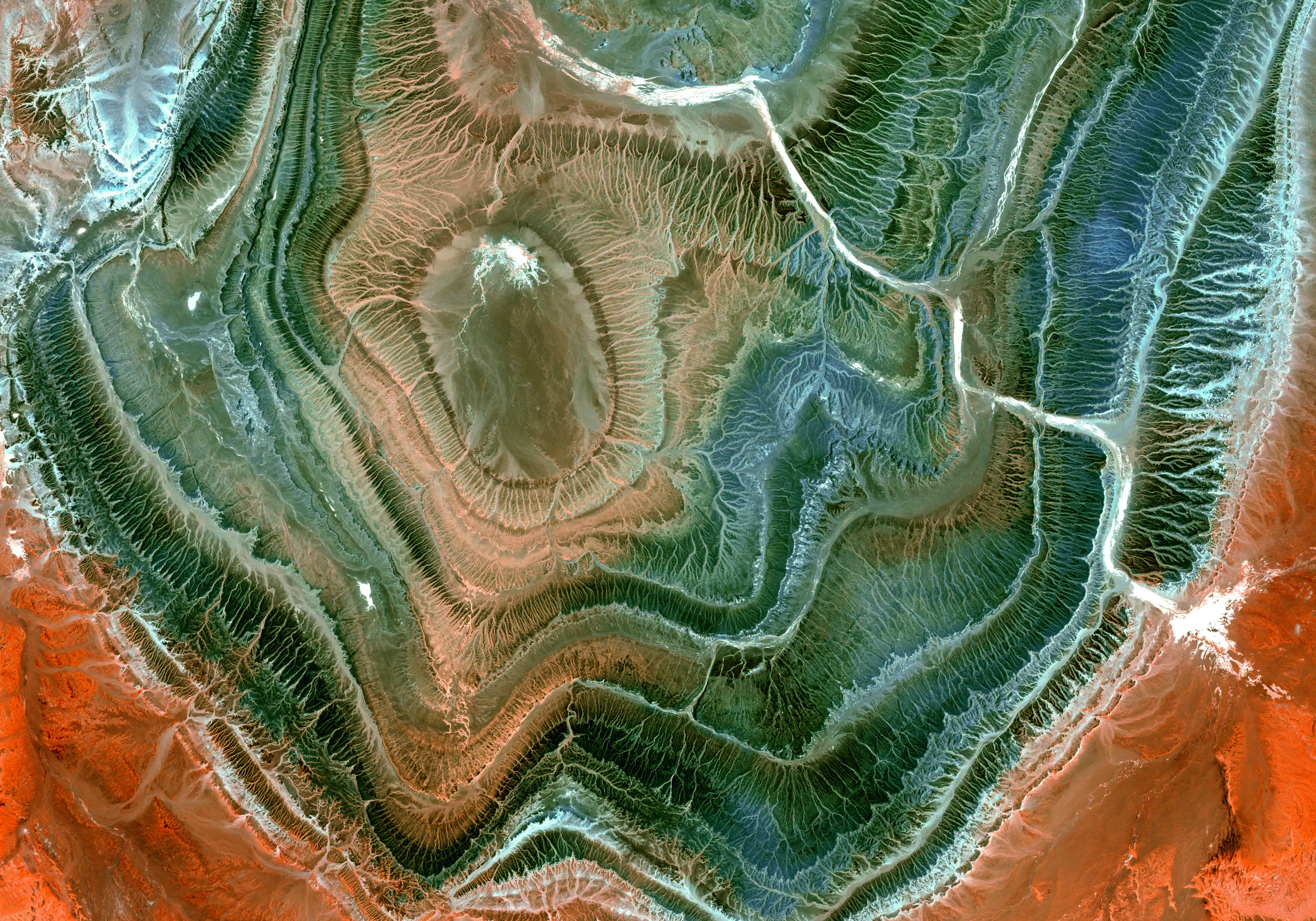
For some of us, it's already time to think about Christmas gifts. Here's a new nice 'geo' book released earlier this month, it's Yann Arthus-Bertrand's Earth from Space, which includes 150 breathtaking satellite images. Wired shares 12 satellite images from the book - worth taking a look.

The book description: "From space, Earth is a magnificent sight, splashed with vivid colors, patterns, textures, and abstract forms. Views from above can also provide telling information about the health of our planet. To help us understand the more than 150 breathtaking satellite photographs in Earth from Space, Yann Arthus-Bertrand, an aerial photographer and devoted environmental activist, discusses the impact of deforestation, urban sprawl, intensive farming, ocean pollution, and more. Using high-resolution imagery, we can monitor the evolution of vegetation around the Chernobyl nuclear disaster site, snow loss on Mount Kilimanjaro, and the health of migratory bird populations. Earth from Space’s compelling selection of satellite images raises important questions about our future, while also showcasing the planet’s beauty—leaving no doubt that it is something crucial to protect."


Galileo Navigation System Gets Go-Ahead From EU Parliament

We actually mentioned Europe's answer to GPS, Galileo, in. Yesterday the following story was discussed over Slashdot, Galileo Navigation System Gets Go-Ahead From EU Parliament.

Their summary: "Plans to start up the EU's first global satellite navigation system (GNSS) built under civilian control, entirely independent of other navigation systems and yet interoperable with them, were approved by MEPs on Wednesday. Both parts of this global system — Galileo and EGNOS — will offer citizens a European alternative to America's GPS or Russia's Glonass signals. The Galileo system could be used in areas such as road safety, fee collection, traffic and parking management, fleet management, emergency call, goods tracking and tracing, online booking, safety of shipping, digital tachographs, animal transport, agricultural planning and environmental protection to drive growth and make citizens' lives easier."

Happy GIS Day

Being busy is no excuse to wish everybody an happy GIS Day! You can learn more about it on gisday and on Wikipedia. And while we're at it, the Geography Awareness Week webpage on National Geographic's website.

Let's quote Wikipedia: "GIS Day is a grassroots educational event that enables geographic information systems (GIS) users and vendors to open their doors to schools, businesses, and the general public to showcase real-world applications of GIS. GIS Day is a global event. Organizations all over the world that use GIS, or are interested in GIS, participate by holding or sponsoring an event of their own. In more than 700 GIS Day events were held in 74 countries around the globe. The first GIS Day occurred in 1999. GIS Day is held the third Wednesday of November each year, during Geography Awareness Week, a geographic literacy initiative sponsored by the National Geographic Society."

Leaflet 0.7 Released and Plans for Leaflet’s Future

The open source lightweight web mapping library Leaflet quickly became very popular in the past year or so, and now there's Leaflet version 0.7 released for us to play with.

From the announcement: "This is a bugfix-heavy release — as Leaflet becomes more and more stable feature-wise, the focus shifts towards stability, usability and API improvements over new features. […] You can check out the detailed changelog of what’s already done over the recent months for 0.7 (about 90 improvements and bugfixes) […] There are several big undertakings in refactoring Leaflet that I’d want to switch to immediately after releasing 0.7 — I’ve been holding them off for too long, and they’ll be extremely beneficial for plugin and Leaflet-based API authors." The full list is available in their announcement.

Batch Geonews: Remaining Relevant as a GIS Professional, OpenGeo Suite 4.0, 30TB of Imagery in Esri, and much more

Here's the recent geonews in batch mode, covering a too long timespan once again.

On the open source / open data front:

  • That's just incredible to see this that snappy in a browser, Dynamic hill shading in the browser
  • Open source software can be popular, over 2,500 participants for the Free CartoDB for Beginners Webinar
  • Tyler Mitchell offers a new book, Geospatial Power Tools - Open Source GDAL / OGR Command Line Utilities
  • With Google Maps API v2 going dark, Upgrading from Google v2 API? Free yourself and upgrade to OpenStreetMap
  • Getting speed, Marble Virtual Globe Graduates OSGeo Incubation
  • GRASS GIS 7 is still in development, but you can learn about it in News in GRASS GIS 7
  • Open source software update, Boundless Releases OpenGeo Suite 4.0
  • Another update, GeoTools 10.1 Released
  • Impressive what you can quickly do with open source javascript libraries, Showing GPS tracks in 3D with three.js and d3.js
  • MapBox, strong contributors to open source geospatial, hired, amongst many others, the creator of Leaflet and Sean Gillies, they also announced MapBox.js v1.4.0

On the Esri front:

  • 30TB of fresh data, Latest DigitalGlobe imagery updates span the globe
  • ArcGIS development is getting multiplatform, Introducing the ArcGIS Runtime SDK for Qt and updates, Version 10.2 of ArcGIS Runtime SDKs for iOS and OS X are now available and Announcing the ArcGIS Runtime SDK for Android v10.2 release!

On the Google front:

  • New versions of Google Earth don't happen every day, Google Earth updated to version 7.1.2.2041, mostly a bugfix release
  • New features in Google Maps, including virtual trips in full 3D, From where you are to where you want to go
  • Another new tool for recording and sharing stories, Tour Builder: Tell your stories with Google Earth
  • Related to the recent international surveillance discussions, Brazil Orders Google To Hand Over Street View Data
  • An interesting story, Revisiting the UTA Flight 772 memorial in Google Earth
  • As usual, New Google Earth Imagery – November 12

In the everything-else category:

  • James is optimistic, Does Ideas4OGC Fix Problems with OGC Standards?, it seems it really helps
  • Geoff has a nice summary named James Fee on remaining relevant as a GIS professional
  • Not from Google, India gets its own Street View: Wonobo
  • While Autonomous Cars Will Save Money and Lives, before more driverless cars, we'll get more driverless trucks, Autonomous Dump Trucks Are Coming To Canada's Oil Sands and why not, UK Town To Get Driverless 'Pods' Mixing With Pedestrians
  • Also related, Driverless Cars Are Further Away Than You Think
  • What's great is that we're also getting closer to Finland's Algorithm-Driven Public Bus
  • In Canada, one of the biggest communications provider is tracking location of all users, no opt-out possible, but it won't be that simple, Is Bell's Plan to Monitor and Profile Canadians Legal?
  • In the same vein, Seattle PD Mum On Tracking By Its New Wi-Fi Mesh Network, and you can also Connect To Unsecured Bluetooth Car Systems To Monitor Traffic Flow, I did not know that even car tires have RFID tags that can be tracked
  • And we mentioned before being tracked in malls, it gets even more serious with Google Starts Tracking Retail Store Visits On Android and iOS
  • Nothing really new there for our regular readers, Police Use James-Bond-Style GPS Bullet, and in the US, Court Rules Probable-Cause Warrant Required For GPS Trackers
  • Not the first time we see a similar initiative, Oregon Extends Push To Track, Tax Drivers Per Mile, and this one titled Police Tracking License Plates Nationwide for Massive Data Base of Citizen Car Trips
  • There's the usual story on the theme of US Mini-Satellites to Track and Kill Terrorists
  • Unsurprisingly, New Job Listings Point to Continued Work on Transit Options in Apple Maps, transit is currently the big absent from Apple Maps, and what might be surprising, Apple Maps Significantly More Popular Than All Other iOS Mapping Apps, Including Google
  • VerySpatial shares an entry named The Geography of Twitter
  • Two articles on maps and marijuana; Tabulating the Underground Economy, and the DEA’s Pathetic Attempt to Map the Marijuana Trade and Unnecessary Environmental Destruction from Marijuana Cultivation in the United States
  • In case you need to know, RapidEye changes name to BlackBridge
  • Remote sensing will be more popular than ever, Government and industry to combine for 1150 satellites over next decade (including telecommunications)

In the maps category:

  • It has been popular recently, the Digital Attack Map, A Live Map of Ongoing DDoS Attacks
  • It happened to Google Maps in, Taiwan Protests Apple Maps That Show Island As Province of China
  • In the U.S.? Is there too much arsenic in the soil where you live? Metals, Minerals, Poisons and Maps
  • Also for the U.S., Two Detailed Rail Maps and an attempt at Mapping Honesty and Property Crime
  • Crime? Police relaunches its crime map
  • Let's learn a bit more, Get to Know a Projection: Lambert Conformal Conic
  • The paper edition is $400, you can get the digital version for $20, The Barrington Atlas Comes to the iPad
  • A map of the Countries most vulnerable to climate change
  • I'm not certain if we shared that link before or not, the excellent series of 40 maps that explain the world