QGIS is amongst the most featureful open source desktop GIS out there, it just got better this week with the release of QGIS 2.6 ‘Brighton’. The visual changelog offers a long description of the new features and improvements. Here’s the index, please follow the link to read the details and see the accompanying screenshots: General Feature: Project filename in properties ...
Read More »Tag Archives: free
“Introduction to GIS” Course in English free of charge
The gvSIG-Training e-Learning platform opens its registration period for the “Basic GIS with gvSIG” MOOC in English, given by the gvSIG Association and GISMAP. This MOOC aims to show the use and potentiality of the open source software gvSIG in performing the most common operations during the workflow in a GIS environment. This Course is addressed to beginners as well ...
Read More »GeoServer 2.6.0 Released
One of the popular geospatial data server just got an update, GeoServer 2.6.0 has been released. Here’s an exhaustive list of talks on GeoServer at FOSS4G. The new features, according to the announcement: WFS Cascade: WFS Cascade has been updated to use a brand new GeoTools wfs client implementation. Curve support for GML and WMS: GeoServer curve support has ...
Read More »Huellasolar launches its OpenPlatform, an online environment to build radiation and sun exposure maps of cities and projects.
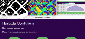
Huellasolar opens its system and offers tools to be used for designers, companies, institutions, architects, engineers, students etc. along the world to build radiation maps of their cities or projects. Generated maps are displayed and shared online thorugh a specifically designed viewer including a lot of features to analyze and get data from the model Monthly and hourly radiation and ...
Read More »OpenLayers 3.0 Released
This is major news. The open source OpenLayers library is one of the most widely used web mapping software. After a complete overhaul of the venerable 2.x branch, OpenLayers 3.0 has been released. From the announcement: “This release includes a ton of new features such as an easier to use API as well as improved vector rendering and image manipulation. […] ...
Read More »QGIS 2.4.0 Released
Formerly known as Quantum GIS, QGIS is one of the most mature open source desktop GIS software. Over the weekend, QGIS 2.4.0 has been released and here’s the visual changelog. From the visual changelog’s introduction: “The emphasis on this release has been very much on polish and performance - we have added many new features, tweaks and enhancements to make ...
Read More »ogr2gui Version 0.7 Released
Inventis today announced the release of ogr2gui version 0.7, the graphical user interface used to convert and manipulate geospatial data. This release would have been possible without the contribution of David Tran in collaboration with Prof. Stefan Keller of the University of Applied Sciences in Rapperswil, Switzerland and Even Rouault from l’École des Mines de Paris. What’s new in this ...
Read More »GDAL/OGR 1.11.0 Released: GeoPackage, Google Map Engine and OpenFileGDB Drivers and more
If there's one geospatial library that is ubiquitous, both in open source and proprietary software, it's that one. Lots of users may not even know they're indirectly using the open source GDAL/OGR library. Well, about a year after version 1.10.0, this widely used tool is now improved with this new version, GDAL/OGR 1.11.0.
The major changes according to the release notes:
-
New GDAL drivers:
- KRO: read/write support for KRO KOKOR Raw format
-
New OGR drivers:
- CartoDB : read/write support
- GME (Google Map Engine) : read/write support
- GPKG (GeoPackage): read-write support (vector part of the spec.)
- OpenFileGDB: read-only support (no external dependency)
- SXF: read-only support
- WALK : read-only support
- WAsP .map : read-write support
- Significantly improved drivers: GML, LIBKML
- RFC 40: enhanced RAT support (#5129)
- RFC 41: multiple geometry fields support
- RFC 42: OGR Layer laundered field lookup
- RFC 43: add GDALMajorObject::GetMetadataDomainList?() (#5275)
- RFC 45: GDAL datasets and raster bands as virtual memory mapping
- Upgrade to EPSG 8.2 database
CLAVIN (Cartographic Location And Vicinity INdexer) Version 1.0 Released
We mentioned the project before, and via APB I learned that the open source CLAVIN has released its version 1.0.
From the official page: "CLAVIN (Cartographic Location And Vicinity INdexer) is an award-winning open source software package for document geotagging and geoparsing that employs context-based geographic entity resolution. It extracts location names from unstructured text and resolves them against a gazetteer to produce data-rich geographic entities. CLAVIN does not simply "look up" location names – it uses intelligent heuristics to identify exactly which "Springfield" (for example) was intended by the author, based on the context of the document. CLAVIN also employs fuzzy search to handle incorrectly-spelled location names, and it recognizes alternative names (e.g., "Ivory Coast" and "Côte d'Ivoire") as referring to the same geographic entity. By enriching text documents with structured geo data, CLAVIN enables hierarchical geospatial search and advanced geospatial analytics on unstructured data."
Read More »GeoTools 10.0 Released
Another software that was released at FOSS4G a week ago was the open source Java library GeoTools 10.0.
From the announcement: "Summary of the new features for the GeoTools 10.x series:
- Structured grid coverage readers allow raster data sources that publish composite data products to expose individual rasters (ie granules) for processing, while still providing a seamless experience for rendering. The mosaic and NetCDF modules are the first ones to implement these new interfaces.
- Efficient support for multiple coverages in GridCoverageReader provides ad-hoc access to raster formats that publish more that one data product. A image mosaic made of NetCDF granules and single file NetCDF sources are the first implementors of these new capabilities
- A new implementation of Shapefile DataStore (based on ContentDataStore superclass). This upgrade should be seamless for all users using DataStoreFactoryFinder. If you explicitly made use of the ShapefileDataStore or IndexedShapefileDataStore class please check the upgrade instructions.
- The transform module graduated to supported status, providing a seamless way to rename, retype and hide SimpleFeatureSource attributes, as well as creating new ones based on OGC Expression
- Additional OGC modules for the WCS 2.0 and WCS 2.0 EO models as well as adding XML parsers and encoders
The 10.x series has a number of research and development activities that may be of interest:
- NetCDF has been updated to take advantage of the new coverage API introduced above
- GeoPackage: a sample implementation of the geopackage spec that is currently being developed by the OGC"
![]()