Tag Archives: Google Earth

Google Announces Much Improved 3D Models for Google Earth, Offline Maps for Android, 12 New Map Maker Countries, and more

Today Google announced a few major upcoming features to their map-related products, including much improved 3D models for Google Earth and offline maps for Android.

From APB and the official Google blog :

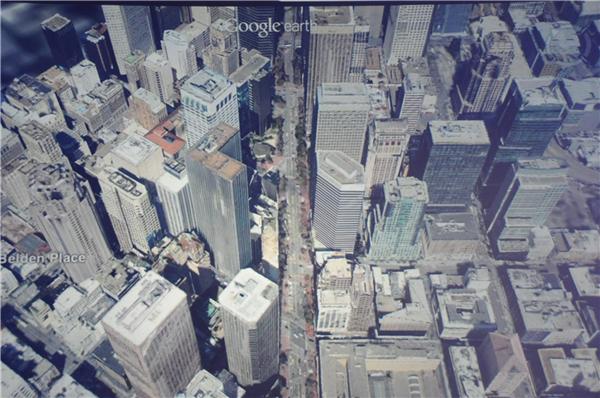
  • On the 3D models: "today we are excited to announce that we will begin adding 3D models to entire metropolitan areas to Google Earth on mobile devices." [...] "[...] advanced automated 3D model creation from imagery. He noted it’s not new, but it far better than what came before. It uses stereo photogrammetry from many well overlapping images. [...] Google is contracting planes to collect the imagery." [...] "By the end of the year we aim to have 3D coverage for metropolitan areas with a combined population of 300 million people."
  • On Android offline maps: "So today we’re announcing that offline Google Maps for Android are coming in the next few weeks. Users will be able to take maps offline from more than 100 countries. This means that the next time you are on the subway, or don’t have a data connection, you can still use our maps."
  • They also announced Street View Trekker: "There’s a whole wilderness out there that is only accessible by foot. Trekker solves that problem by enabling us to photograph beautiful places such as the Grand Canyon so anyone can explore them. All the equipment fits in this one backpack [...]"
  • Map Maker is coming to several new countries (too bad for my hopes of seeing Google move to OpenStreetMap data ;-): "Today we’re announcing the expansion of Map Maker to South Africa and Egypt, and to 10 more countries in the next few weeks: Australia, Austria, Belgium, Denmark, Finland, Liechtenstein, Luxembourg, New Zealand, Norway and Switzerland."

If you want to see screenshots of the event, CNET has plenty of them.


Read More »

DataAppeal: Upgraded Version- Transform your location-based data files into designed 3d and animated maps quickly!

DataAppeal is a new way to map and visualization your data quickly and easily. It transform data into powerful communicative messages! DataAppeal™ provides a web-based mapping application, designed to visualize geospatial data using captivating models and images. DataAppeal™ uses concepts of art and design to render alluring 3D and animated maps, helping to draw the audience to the data. It incorporates artistic measures to dramatize the data, therefore, increasing the interest in your information. Users upload a data file, and they can design their data using pre-defined 3D shapes, textures, various colors,time, and other visual effects to show hidden trends and concealed meanings. DataAppeal just released an upgraded version to include the option of layering multiple maps so users can quickly compare different data sets. Users can also try the new color gradient feature to quickly see common data points. All these features will continue to be free for a limited time, so you can see how useful they are when analyzing your data.

Read More »

Google Geonews: Google Earth 6.2 for Android and iOS, New 45° Imagery for 56 Cities, and much more

Here's the recent Google-related geonews.

From the official sources:

  • Two days ago was announced Google Earth 6.2 for Android and iOS, which includes support for KML files and the Google Earth Gallery is available from within the app
  • There's new 45° imagery available for 56 cities: 23 U.S. and 33 international locations
  • There's New Satellite Imagery of Japan’s Disaster Areas in Google Maps
  • There was an official entry named Google and Historypin launch online gallery to celebrate The Queen’s Diamond Jubilee
  • And if you feel like it, you can explore San Francisco in 1938 through aerial photography in Google Earth
  • And finally, an entry on protecting the world’s coral reefs through mapping

From other sources:

  • Thierry links to an article about a new section of the Great Wall of China discovered in Mongolia thanks to Google Earth
  • Ogle Earth answers the question whether Google is showing India’s Assam state as part of China or not, and the answer is 'no'
  • Spatial Sustain has a short entry on Google Street View images on ski slopes
Read More »

A Cool Mashup of Google Maps + Google Earth + Yahoo Maps + Bing Maps


A lot of Maps applications are being developed recently. Each with its pros and cons, I recently wrote an article that compares Google Maps VS Bing Maps. People seem to like it.

So the Punch line, I decided to create a cool mashup that combines 4 Maps applications,

  1. Google Maps
  2. Google Earth
  3. Bing Maps
  4. Yahoo Maps

When you zoom or pan in Google Maps ALL 4 Maps are getting updated instantly!

Click here for the Tool


Read More »

Batch Geonews: StreetView now in Russia, Should GIS Users Code?, ArcGIS 10.1 Enhancements, and much more

Here's the recent geonews in batch mode. My challenge in life is to find out what not to do - too much enthusiasm impacts focus. But don't worry, I'm not dropping Slashgeo just yet ;-)

From the open source and open data front:

  • Here's an open source Kinect hack named Depthcam, doing live streaming of 3D points cloud via your webcam
  • Via Simon, I was reminded about Graphserver, an open source multi-modal trip planner (we mentioned Graphserver), on the same topic, here's OSM Explorer, for basic routing and spatial functions using OSM data on Windows (via OGD)
  • MapQuest updated their OpenStreetMap tiles and mentions more OSM switchovers, such as FourSquare and in another entry, they updated MapQuest for Android
  • Here's an entry on light styles for OSM layers in QGIS, making OSM great as a base map
  • Quebec City is the latest city to open its data, with layers in shapefiles and kml, and here's an entry on Honolulu opening its data
  • The OSGeo-Live DVD version 5.5 is now ready

From the Google front:

  • Street View on Google Maps now available for Russia
  • The GEB introduces Diorama, a presentation tool for Google Earth, helping you tell a story in Google Earth
  • The same blog also look a the Power of Ten, the Google Earth version
  • Google explains the enhanced search in Google Earth 6.2
  • Here's an entry on the iNaturalist app and website using georeferenced pictures to document nature
  • The GEB wonders if historical imagery is coming to Street View?
  • And yes, there was fresh imagery released about two weeks ago and another round today

From the Esri front:

  • Here's why ArcGIS 10.1 will be the “Biggest Release Ever”
  • Here's Esri’s Federal GIS Conference Wrap Up
  • Here's the recommended System Requirements For ArcGIS 10/10.1
  • Mandown also shares an entry named Using ArcGIS For Quick Visualisation Of GPX Files

From the Microsoft front:

  • Microsoft announced the Bing Maps and Nokia Release of a Unified Map Design

In the miscellaneous category:

  • DM asks an interesting question, Should All GIS Users Learn to Code?
  • While not all are geo-aware, this is an awesome categorized list of infographic tools and resources, because beauty matters when conveying information (via Thierry)
  • The book "How Maps Change Things: A Conversation About the Maps We Choose and the World We Want" by Ward Kaiser is free in pdf for this month
  • We previously mentioned that the world time zones database was in jeopardy, well, it's not anymore, EFF Wins Protection For Time Zone Database
  • Here's an entry on OGC mobile case studies
  • Here's a Product Review of BusinessWebMap by TexMobile
  • Slashdot mentions the link between GPS navigation and in-car voice commands in Siri To Power Mercedes-Benz Car Systems
  • APB informs us that DigitalGlobe published an image of damage to Homs, Syria

In the maps category:

  • APB shares the map of sleep in the U.S.
  • Slashdot discussed a story named LIDAR Map Shows Height of Earth's Forests
  • Another story from the same source is named Need To Find a Hackerspace In Africa? Check This Map
  • If your into astronomy, check this TMR entry on Moon maps
  • Mapperz mentions Bristol's solar power hotspots map
Read More »

Google Geonews: New Bathymetry and Seafloor in Google Earth, new 45deg imagery, StreetView in Botswana Coming, and more

Here's the recent Google-related geonews in batch mode.

From official sources:

  • Google released a major update to the bathymetry and seafloor display in Google Earth
  • There's new 45 degrees imagery available for 24 cities:
    • "US: Charleston-Folly Beach, SC; Lee’s Summit, KS; Lexington, SC; Magna (Salt Lake City), UT; North Charleston, SC; Pine Island Center, FL; Plymouth, MN; Salinas CA; Santa Rosa, CA; Shawnee, KS; South Hill, WA; Spanish Springs, NV; Killeen, TX; Decatur, AL
    • Europe: Torrelavega, Spain; Pamplona, Spain; San Sebastian, Spain; Bailen, Spain; Rolle, Switzerland; Ponferrada, Spain; Wachtberg, Germany; Weinheim, Germany
    • South America: Buenos Aires, Argentina"
  • There's a new biking directions legend in Google Maps
  • Ed Parsons mentions the coming of Street View in Botswana

From other sources:

  • The GEB shares a 3D tour of the Costa Concordia recent ship wreck
  • While there's apparently no new data involved, the GEB shares an entry on the city lights of Earth at night in Google Earth
  • The GEB also shares an entry on the Monster Milktruck game in Google Earth and an entry on a new book named Google SketchUp for Game Design
  • To end with a funny note, APB shares a quote regarding the "removal" of Atlantis from the Google Earth seafloor by manually cleaning the data 
Read More »

Google Earth 6.2 Released: Seamless Globe and Google+ Integration

Yesterday, Google released Google Earth 6.2. 

From the announcement: "With Google Earth 6.2, we’re bringing you the most beautiful Google Earth yet, with more seamless imagery and a new search interface. Additionally, we’ve introduced a feature that enables you to share an image from within Google Earth, so you can now simply and easily share your virtual adventures with family and friends on Google+. [...] We’ve also made some updates to the search feature in Google Earth. Aside from streamlining the visual design of the search panel, we’ve enabled the same Autocomplete feature that's available in Google Maps." 

On the welcomed seamless globe: "While this change will appear on all versions of Google Earth, the 6.2 release provides the best viewing experience for this new data." Sri Lanka, before and after:

Sri Lanka

A quick reminder, Slashgeo has its Google+ page too (but it's inactive at the moment, that doesn't mean it's not worth adding it to your circles ;-).

Related, the GEB shares an entry named Google Earth 6 now required for Street View.

Read More »

Batch Geonews: Pleiades-1 in Orbit, GeoInt at the US DoD, Hyperspectral UAV, GLONASS Global, and much more

Here's the recent geonews in batch mode. I've been overly busy lately - like a lot of us are at that time of the year I guess - please allow the unusual delay of this entry. Have a nice holiday break!

On the Esri front:

  • Via an Esri email, I learned about the National Geographic World Map to be used as a basemap with Esri products and services

On the Google front:

  • Again, there's new 45° imagery available, now for Detroit, Fayetteville, Nashville, Baton Rouge and Huntsville
  • The GEB has an entry on Google Earth on the Samsung Galaxy Nexus
  • The GEB also shares another entry on using Google Earth in the classroom
  • Finally from the GEB, here's an entry named Visualizing Google Analytics data in Google Earth
  • Slashdot is discussing a story about British Telecom suing Google over Android, including several location-related patents
  • Here's the official entry on last week's imagery update

In the miscellaneous category:

  • APB shares their top 10 GIS stories
  • SS informs us that France's Pleiades-1 high-resolution is now in orbit: "Pleiades-1 has a 70cm resolution, mulitspectral views in the visible and near-infrared bands, and a swath width of 20km"
  • Read this if you want to grasp how important geospatial intelligence is to the US Department of Defense
  • We often mentioned the LightSquared debacle, now they want the FCC to rule now, not a bad idea since they might run out of money in the coming months
  • SS also informs us of an hyperspectral imager that can be deployed on UAVs
  • We mentioned GeoSMS before, here's the OGC blog the use of GeoSMS for disaster management
  • APB informs us that Facebook added Location Tagging to their Timeline Rollout
  • Two weeks ago in a PR we mentioned GISLounge's GIS job skills and employment survey
  • Also from a recent PR, we never mentioned before the free Dinamica EGO software, now at version 1.8, EGO standing for Environment for Geoprocessing Objects
  • V1 informs us that Russia's GLONASS satellite navigation system is officially global again
  • Slashdot discusses how the brain's structure changes with your spacial and navigation skills, at least for taxi drivers
  • Another location-related story discussed at the same place is named Japanese Use Wild Monkeys To Track Radiation
  • Finally from the same source, DigitalGlobe's satellite spotted China's first aircraft carrier
  • WebMapSolutions reviews 8 mobile GIS apps for iOS and Android
  • Microsoft tells us about the Updated Spatial Features in the SQL Azure Q4 Service Release
  • MapQuest updated their Mobile Flash Maps API to v7.0.7, but with Flash for Mobile officially abandoned by Adobe, what's the future of Flash?
  • O'Reilly shares a long entry on the Public Mapping Project for gerrymandering the U.S. elections, which we mentioned before
  • Hum... APB shares an entry named Confidence Key to Women Doing Well at Spatial Tasks

In the maps category:

  • While I'm a bit late for Christmas gifts, VS mentions interesting typographic maps of various U.S. cities on sale, VS also links to reasonably priced 'vintage' geography gifts
  • Here's OWNI's list of Best Maps, a few of them previously mentioned here
  • Discussed over Slashdot, a New All-Sky Map Shows the Magnetic Fields of the Milky Way
  • O'Reilly shares this British map of traffic casualties
Read More »

Google Geonews: Numerous New 45° and 3D Cities, New Map Maker UI, Google Launches Schemer, and much more

Here's the recent Google-related geonews.

From official sources:

  • There's new 45° imagery available for nothing less than 21 cities: "U.S.: Albuquerque (west), NM; Benton, AR; Boulder, CO; Eldridge, IA; Boston (east), MA; Centennial (south), CO; GooglePlex, CA; Indianapolis (south), IN; Las Vegas Strip, NV; Montgomery (outskirts), AL; Olathe, KA; Petaluma, CA; Tulsa, OK. South America: Brasilia, Brazil"
  • ​On a similar topic, there's new cities in 3D in Google Maps: Rome, Seville, Las Vegas and more - the full list: "US: Foster City, Honolulu, Las Vegas, Norfolk,Palo Alto, Portland, Redwood City, Riverside, Salt Lake City, San Antonio, San Diego, Santa Cruz, Sunnyvale. Europe: Rome, IT, Rotterdam, NL; Seville, ES; Stuttgart, DE, Amsterdam, NL"
  • Google Map Maker has been revamped with a new user interface, my hope is that one day Google will surprise us and link Google Map Maker with OpenStreetMap - they could eventually do it, since Google doesn't make money out of the data directly anyway and they're already great supporters of open data - am I delusional? :-)
  • Somewhat related, Google Maps data got improved in the United Kingdom, Germany, Finland and Sweden
  • The official Dev blog shares an entry named The power of visualization with the Google Analytics API and Google Earth
  • We also previously mentioned Liquid Galaxy, and now they're running Google Earth on 48 screens! The code is open source is your living room is big enough 
  • Here's a new entry on the tsunami-affected areas of Japan in Street View
  • Here's an entry named Exploring ancient ruins in 3D with Google Earth

From other sources:

  • The GEB reports about new high-resolution imagery in Antarctica in Google Earth
  • APB mentioned Google blocking a first person shooter "game" in Google Maps
  • The GEB also has an entry on the reorganization of the 'Ocean' layer
  • Still from the same source, here's how to View your Google Latitude history in Google Earth
  • Ed Parsons mentioned that satellite images revealed a “secret” Nevada UAV site
  • Finally, the GEB is excited about the 3D tours of Mount Urgull in San Sebastian, Spain
  • SS informs us that Google purchased Clever Sense, which tagline was "Never Miss Places You’ll Love", and APB informs us that Google launched Schemer, a non-checking location-based service for finding what to do, it's in invite-only beta
Read More »

Google Geonews: Map API Limits Details, StreetView in Belgium and Ski Slopes, Fusion Tables, and much more

Here's the recent Google geonews.

From official sources:

  • Here's another entry providing even more information on understanding how the Maps API usage limits affect your sites
  • Google shared another entry on indoor mapping in Google Maps
  • Street View goes to Belgium
  • Here's the official entry on on the ski and snow edition of the Street View special collections
  • For those using the Google Maps API, here's Four Tips for Improving Your Mobile Web Map App
  • They also have an entry on visualizing water and energy solutions in a warming world
  • Here's a story about using Google Fusion Tables along with Google Maps
  • Via Ed Parsons, here's a short nice stop-motion movie using Google Street View named 'Address is Approximate'

From other sources:

  • If you don't want to use Fusion Tables, here's how to Dynamically Map your Google Spreadsheets with GeoCommons
  • You might be interested in previewing the London Olympics in Google Earth
  • Kurt reminds of what Google Oceans is all about
  • Ogle Earth today shared an entry named Iran missile base post-explosion imagery, now hi-res in Google Earth
  • In Google Earth, you can see Captain James Cook's circumnavigation of New Zealand
  • Here's NASA using 'Google Earth Portable' in Canada
  • Oh, and last weekend, there was another round of imagery update to Google Earth
Read More »