Tag Archives: Google Maps

Google Geonews: Google Dev Glasses Available, Google Earth for Android 7 Released with 3D Cities, and more

Here's recent Google-related geonews, with some pretty interesting.

  • While there's a new uninformative official entry on Project Glass, their augmented reality glasses we mentioned in April, Slashdot provides more information in this entry named More Details On Google Glass, including: "As we mentioned earlier, the developers at I/O have the option to buy the 'Explorer Edition' of Google Glass for $1,500. In addition to the (functional, but unfinished) device itself, they also get access to Google's engineers and to keep up with the devices development. Worry not: when the consumer version of the device is finalized, it will be cheaper, but of course they aren't ready to talk about actual prices yet. As for availability: "Less than a year after we get these Explorer Editions out.""

From official sources:

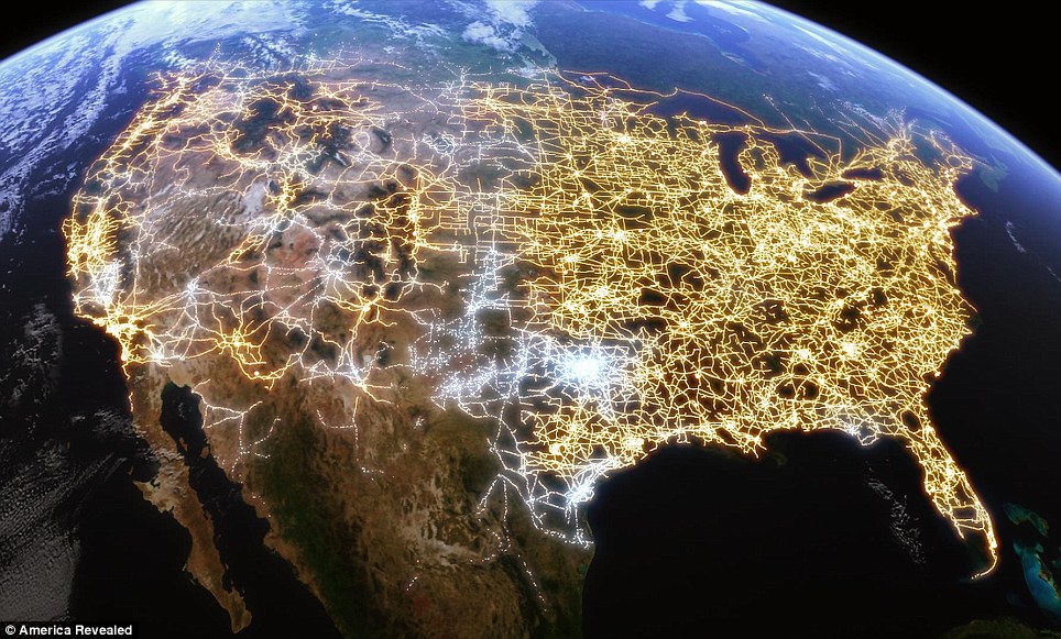
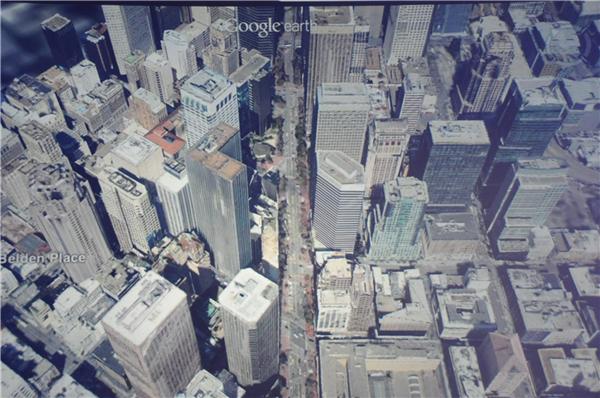
  • A new Google Earth for Android version is out, with new 3D cities imagery, yes, that's the new great city imagery similar to what Apple Maps will provide with iOS 6, and Google will soon provide a new  iOS version of Google Earth too. The other major feature is the 'Tour guide': "We’ve put together short tours of thousands of famous places and historical sites across the globe so it’s easier than ever to discover amazing places." Here's which cities have the new 3D imagery: "Boulder, Boston, Charlotte, Lawrence, Los Angeles, Long Beach, Portland, San Antonio, San Diego, San Francisco, Santa Cruz and Tampa in the United States, along with Rome, Italy."
  • The Dev blog announced that Public transit routing and layer now are now available in the Google Maps API
  • It was announced and it's now reality, you can now Go offline with Google Maps for Android
  • And because we need to seriously take care of our home, Planet Earth, Google shares Geo in Rio: Cool Tools for a Warming Planet, and another related official entry is about Crowdsourcing Forest Monitoring
  • The official Dev blog shares an entry on symbols and heatmaps for the Google Maps API
Read More »

Google Slashes Price 88% for using Google Maps API and Adds Map-Based Ads

Shortly after Apple dumped Google Maps for iOS, Google announces it's time to dramatically cut the price for others using the online service. Google also gives a plug for its map-based ad service.

Editor's note: in addition to this CNET article shared by user 'rk', the official Google Geo Developers Blog shares a full entry on the topic: "We’re beginning to monitor Maps API usage starting today, and, based on current usage, fees will only apply to the top 0.35% of sites regularly exceeding the published limits of 25,000 map loads every day for 90 consecutive days. We aren’t automating the application of these limits, so if your site consistently uses more than the free maps allowance we’ll contact you to discuss your options. Please rest assured that your map will not stop working due to a sudden surge in popularity."

Read More »

Batch Geonews: Stats on Mobile Maps, OpenLayers 3 News, Fantasy Maps, and some more

Here's the recent geonews in batch mode.

On the open source front:

  • Wonder where OpenLayers 3 is heading?
  • ImageI/O-Ext 1.1.4 was released
  • Here's a short entry on creating hillshades with gdaldem

In the miscellaneous category:

  • O'Reilly links to a few interesting stats on mobile maps in the context of Apple Maps vs Google Maps, including "In the US, Google gets about 31 million users a month on its Maps app on iOS. On average those users spend more than 75 minutes apiece in the app each month." and "90% of all iOS users used the Google Maps app at least once during April. Only 71% of Android users used the Google Maps app."
  • Slashdot discussed a story named Chuck Schumer Tells Apple and Google To "Curb Your Spy Planes", referring to the new high-resolution imagery coming later this year to Apple Maps and Google Maps

In the maps category:

  • TMR shares an entry on fantasy maps, with the book 'Here be dragons' by Stefan Ekman
  • Via O'Reilly, I stumbled onto the Art of GPS article which shares beautiful GPS-related visualizations, here's the U.S. electricity network


Read More »

Google Announces Much Improved 3D Models for Google Earth, Offline Maps for Android, 12 New Map Maker Countries, and more

Today Google announced a few major upcoming features to their map-related products, including much improved 3D models for Google Earth and offline maps for Android.

From APB and the official Google blog :

  • On the 3D models: "today we are excited to announce that we will begin adding 3D models to entire metropolitan areas to Google Earth on mobile devices." [...] "[...] advanced automated 3D model creation from imagery. He noted it’s not new, but it far better than what came before. It uses stereo photogrammetry from many well overlapping images. [...] Google is contracting planes to collect the imagery." [...] "By the end of the year we aim to have 3D coverage for metropolitan areas with a combined population of 300 million people."
  • On Android offline maps: "So today we’re announcing that offline Google Maps for Android are coming in the next few weeks. Users will be able to take maps offline from more than 100 countries. This means that the next time you are on the subway, or don’t have a data connection, you can still use our maps."
  • They also announced Street View Trekker: "There’s a whole wilderness out there that is only accessible by foot. Trekker solves that problem by enabling us to photograph beautiful places such as the Grand Canyon so anyone can explore them. All the equipment fits in this one backpack [...]"
  • Map Maker is coming to several new countries (too bad for my hopes of seeing Google move to OpenStreetMap data ;-): "Today we’re announcing the expansion of Map Maker to South Africa and Egypt, and to 10 more countries in the next few weeks: Australia, Austria, Belgium, Denmark, Finland, Liechtenstein, Luxembourg, New Zealand, Norway and Switzerland."

If you want to see screenshots of the event, CNET has plenty of them.


Read More »

The Next Dimension of Google Maps Event Announced for June 6th

While we'll know in a few days what this presumably big announcement in terms of upcoming features is all about, Google sent an invitation to 'The Next Dimension of Google Maps' event that will be hosted next Wednesday. In addition to CNET, I saw it featured on Slashdot and MacRumors.

From the invitation: "At this invitation-only press gathering, Brian McClendon, VP of Google Maps and Google Earth, will give you a behind-the-scenes look at Google Maps and share our vision. We'll also demo some of the newest technology and provide a sneak peek at upcoming features that will help people get where they want to go -- both physically and virtually. We hope to see you there."

I like MacRumors' analysis: "The timing of Google's event naturally leads to speculation that it has been specifically planned to upstage any Apple announcement about mapping in iOS 6 and to show what users will be missing out on with the transition by Apple."

Read More »

Google Geonews: Indoor Directions for Android, Spreadsheet Mapper 3, Google Earth Builder Renamed Google Maps Engine, and much more

Catching up geonews, here's the recent Google-related geonews.

From official sources:

  • The latest Google Maps 6.7 for Android introduces Google Offers and Indoor walking directions
  • We mentioned Speadsheet Mapper in, and now Spreadsheet Mapper 3 is available, in short, "Spreadsheet Mapper is a tool that enables anyone to easily create a well-designed  KML file  to show off their data in Google Earth and Maps"
  • The Baltic nations of Estonia and Latvia are now in Street View
  • Here's the 'Model your Town' winner, Getaria, Spain
  • In Google Maps, 'work' and 'home' made their way to My Places
  • Regarding Google Earth Builder that was renamed Google Maps Engine, nonprofits can have it for free
  • Here's the latest improvements of the Google Places API searches
  • And of course there was an imagery update on May 14th, and on May 4th too

From other sources:

  • Slashdot mentioned Google Gets Driverless License For Nevada Roads
  • At the beginning of the month, the GEB showed the One World Trade Center building model in Google Earth, and later, Saint Basil's Cathedral
  • Using Google's Fusion Table on mobile devices? Look at My Fusion Tables
  • Slashdot discussed a story named Google Releases Key Part of Street View Pipeline
Read More »

Google Geonews: Google Maps Cube Game Unleashes, Photo Tours in Google Maps Announced, New 45° Imagery, and much more

Some pretty interesting Google geonews in batch mode.

From official sources:

  • Google announced Photo tours in Google Maps: "Photo tours are available for more than 15,000 popular sites around the world [...] To produce these photo tours, we use advanced computer vision techniques to create a 3D experience from public, user-contributed Picasa and Panaromio photos."
  • The new 3D buildings announced last month are now available in Google MapsGL
  • There's new 45° imagery available for 19 cities, International: Avignon, France; Reus, Spain; Rotterdam, Netherlands; L'Alcudia, Spain; Gandia, Spain; Sueca, Spain; Burgos, Spain; Los Palacios Y Villafranca, Spain, US: Albany, GA; Omaha, NE; Baytown, TX; Miami, FL; Amarillo, TX; Monroe, LA; Manchester, NH; Alexandria, LA; Rapid City, SD; Loudon, TN; Farmington, NM
  • Street View is now available in Ukraine

From other sources:

  • It's James that made me aware that the Google Maps game 'Maps Cube' is available, I couldn't test it yet on the Linux machine in front of me. Here's how James describes it: "Basically you use your mouse to tilt a 3D cube and have a ball travel down the transportation networks (road, trails, subways, etc). Since we in GIS all know about topology in these networks, the game isn’t as hard as you might expect. Still it’s a pretty amazing example of using HTML + WebGL for web mapping." APB also links to a short PC Mag article on the Maps Cube Game.
  • The GEB shares an update on the impressive Data Appeal visualization tool for Google Earth
  • Slashdot also ran the story named Google Releases FCC Report On Street View Probe
  • If you want analysis of Trimble's acquisition of SketchUp from Google, read more from the GEB, from Spatial Sustain,
  • Here's Plymouth, Michigan in 3D
  • And to end with something funny, here's UFO Sightings in Google Earth

Read More »

Google Geonews: Google Maps gets Real-Time Traffic and More Coverage, Google Maps for Android 6.5, New 45° Imagery, and much more

Google is clearly one of the most news-generating entity in the geospatial industry. Here's the recent Google-related geonews.

From official sources:

  • Google now uses live traffic data alongside with historical data  for trip durations in Google Maps, they use the My Location feature on Google Maps for Android to extrapolate live traffic conditions. This news was also discussed over Slashdot
  • And if that isn't enough, we now get typical traffic for roads, not just highways
  • Here are the finalists for the Google Model Your Town Competition 2012
  • Google Maps for Android got a fresh look with version 6.5
  • Google released the Google Maps Floor Plan Marker app, to help orient customer in businesses 
  • Mix art and Street View and you get the Google Art Project
  • You can now see service alerts for the London Underground in Maps
  • Traffic and Transit Come to Google Maps in Malaysia
  • And there's new 45° imagery available for 15 cities: US: Atlanta, GA; Canyon Lake, TX; Charleston, SC; Dallas, TX; Houston, TX; Lakeland, FL; Lubbock, TX; Orlando, FL; Port Charlotte, FL; Roanoke, TX; San Luis Obispo, CA; Smyrna, TN; Walker, LA. International: Adelaide, Australia; Cordoba, Argentina
  • The Weather Layer is now available in the Google Maps API

From other sources:

  • The GEB found out about the latest imagery update in Google Earth yesterday
  • The GEB also shares an entry named Exposing Shantytowns in India with Google Earth
Read More »

Google Maps Introduces 8-Bit Quest Maps for April Fools

While this is an April Fools related story, it's 100% real and live, at least for today. I learned about it on Slashdot in a story named Google Maps Introduces 8-Bit Quest Maps. StreetView is quite bizarre in 8 bits...

From the official Google Lat Long blog: "With Google Maps 8-bit, you can do all the things you already do on regular Google Maps. Search for famous landmarks and sites around the world. Take an epic journey with 8-bit Street View. Get detailed directions to avoid dangerous paths, and battle your way through a world of powerful monsters and mystic treasures."

The Slashdot summary: "Today users of Google Maps will notice a new mapping option — 'Quest' — alongside the usual 'Map' and 'Satellite' views. Quest view renders the planet in a retro 8-bit fantasy video game style, including renders of famous landmarks such as the White House and the Eiffel Tower. Even Pegman gets in on the game, now taking on the appearance of a sword wielding 8-bit adventurer, allowing you to witness Street View through 8-bit eyes. Basically, imagine a fully functioning Google Maps on an NES."

The 2-minutes video shows what this is about and is funny (but you'll have to test StreetView yourself since they don't show it in the video).


Read More »

Google Geonews: Google Earth 6.2 for Android and iOS, New 45° Imagery for 56 Cities, and much more

Here's the recent Google-related geonews.

From the official sources:

  • Two days ago was announced Google Earth 6.2 for Android and iOS, which includes support for KML files and the Google Earth Gallery is available from within the app
  • There's new 45° imagery available for 56 cities: 23 U.S. and 33 international locations
  • There's New Satellite Imagery of Japan’s Disaster Areas in Google Maps
  • There was an official entry named Google and Historypin launch online gallery to celebrate The Queen’s Diamond Jubilee
  • And if you feel like it, you can explore San Francisco in 1938 through aerial photography in Google Earth
  • And finally, an entry on protecting the world’s coral reefs through mapping

From other sources:

  • Thierry links to an article about a new section of the Great Wall of China discovered in Mongolia thanks to Google Earth
  • Ogle Earth answers the question whether Google is showing India’s Assam state as part of China or not, and the answer is 'no'
  • Spatial Sustain has a short entry on Google Street View images on ski slopes
Read More »