Supergeo Technologies, a leading global provider of GIS software and solutions, announces that SuperSurv M3, the professional mobile GIS app for Android and iOS powered devices, is now on 50% off sale until June 30, to bring more possibilities for GIS field surveyors. Positioned for convenient data capturing, SuperSurv is the professional GIS app specially designed for Android ...
Read More »Tag Archives: mobile GIS
Supergeo to Showcase the Latest GIS Technologies in Kuwait
Supergeo Technologies, a leading global provider of GIS software and solutions, is going to attend the Conference of Discover GIS II during 27-28 May in Kuwait. Integrated International Environment Services (IIES), Supergeo Platinum Reseller in Kuwait, and Evolving Geosystems, Supergeo reseller in UAE, will also join the event to demonstrate successful applications for all users.
Organized by the Kuwait Geographical Society and Beyond Co., the Conference of Discover GIS II is one of the most important geospatial exhibitions in Kuwait and the Middle East region. Experts and professionals from governments, companies and research institutes will gather to exchange up-to-date and innovative technologies of GIS industry.
To bring advanced applications for more Middle Eastern users, Supergeo and IIES will co-exhibit in the conference. Except for showing the latest 3D map viewing and publishing software, SuperGIS 3D Earth Server, Supergeo will also present mobile apps for smart mapping and surveying to help users with enhanced efficiency and data accuracy.
In addition to conference events, Supergeo will gladly present SuperGIS Application Excellence Award to PAAF, Kuwait. With previous successful cases, such as Remediation of Sabah Al-Ahmad Nature Reserve, Supergeo has built up strong network and support with IIES for users in the Middle East. Through this conference, more GIS professionals can well apply GIS to more application domains.
# # #
About Supergeo
Supergeo Technologies Inc. is a leading global provider of GIS software and solutions. Since the establishment, Supergeo has been dedicated to providing state-of-the-art geospatial technologies and comprehensive services for customers around the world. It is our vision to help users utilize geospatial technologies to create a better world.
Supergeo software and applications have been spread over the world to be the backbone of the world’s mapping and spatial analysis. Supergeo is the professional GIS vendor, providing GIS-related users with complete GIS solutions for desktop, mobile, server, and Internet platforms.
Read More »
Jakarta Fire Department Utilizes SuperPad to Secure Citizens and Properties
Supergeo Technologies, a leading global provider of GIS software and solutions, assists the Department of Building and Fire, Bekasi, Jakarta in enhancing citizens’ life through SuperPad, the professional GIS data capture application. The project is contributed by Datascrip, Supergeo partner in Jakarta.
The Department of Building and Fire, Bekasi, Jakarta is responsible for protecting and securing the safety of its citizens. Except for the fire control missions, the Department also has to prevent any kind of disasters, maintain infrastructures and provide related counsels in a timely way.
With SuperPad, the firemen and department staffs can collect the first-hand data and update it in real-time, so that other co-workers, no matter in the office, at the scene or on the way, can receive the latest information to better plan the rescue resources and therefore prevent more loss. The application also allows users to edit, measure, query and display spatial data. Several custom tools, like Advanced Attribute Table, Network Tool, etc. are also provided for more efficient uses.
Supergeo develops GIS software and provides total solutions for aiding worldwide users to increase their work values with geospatial technologies. The SuperGIS applications have been applied to diverse fields, including safety control, emergency response, urban planning, natural resource management etc. Supergeo will be showcasing these GIS solutions during FIG Congress and Asia Geospatial Forum to interact with more users.
# # #
About Supergeo
Supergeo Technologies Inc. is a leading global provider of GIS software and solutions. Since the establishment, Supergeo has been dedicated to providing state-of-the-art geospatial technologies and comprehensive services for customers around the world. It is our vision to help users utilize geospatial technologies to create a better world.
Supergeo software and applications have been spread over the world to be the backbone of the world’s mapping and spatial analysis. Supergeo is the professional GIS vendor, providing GIS-related users with complete GIS solutions for desktop, mobile, server, and Internet platforms.
Read More »
Fulcrum Adds Real-Time Data Publishing Features
Many of Fulcrum’s users are in the field collecting data which later needs to be shared with various stakeholders, like clients, government agencies, or management team members. We recently released a feature that makes this process even easier. Data Shares allow you to generate simple URLs for downloading or accessing data within your Fulcrum Apps that you can publish or share.
Now, all users with Small plans and above have Data Shares available. An account’s owner can enable sharing for a specific App, and then have access to a URL that serves up that data in a variety of formats: CSV, KML, GeoJSON, or JSON. The owner can then give the link to, for example, a client. Each time the client accesses the link, they’ll pull up-to-date data from that App.
Being able to access your App’s data easily in multiple formats allows for sophisticated uses of that information in real-time.
Why This is Powerful
Data collection efforts are often continuous, with teams out in the field on a daily basis conducting inspections, user surveys, or field reports hour by hour, and syncing them to the cloud where the information can be visualized or exported. Many users export data as CSV on a recurring basis to analyze or merge with other data on their own systems. Now, once a data share has been enabled, you’ll be able to have their script use the URL to automatically fetch fresh data without running an export.
It’s powerful to visualize the data you collect, especially to quickly convey progress to stakeholders. Now it’s much easier to build a web map that uses current data each time the map is refreshed. You can use something like Bootleaf and a GeoJSON data share to easily display the data you’ve collected on a map. There are many parameters that can be used to customize the data returned to give a lot of flexibility and control.
Other users may have used the Google Earth Streaming capability to quickly visualize the data they collect. But that shows data from all your Apps. Using a KML data share will allow this same, quick visualization scoped to just the App you want to share.
Using QGIS, the free and open source GIS software, you can even use a GeoJSON data share URL and add your live data to a QGIS map project using the data share URL. This is fantastic for getting a mappable layer into a GIS for combining with your other GIS data layers.
We hope these examples give you an idea of what else you can do with Data Shares and how valuable they’ll be to your efforts to use your data once collected.
About Fulcrum
Fulcrum is a mobile data collection platform built to allow users to design custom field survey form templates to deploy to mobile staff on iOS and Android devices. Since, Fulcrum has been helping organizations with mobile field staff save time and money, and collect better GIS information. Read more about Fulcrum by visiting the website, or follow us on Twitter or Facebook for updates.
Read More »Nature Reserve Remediation in Kuwait by SuperGIS Solutions
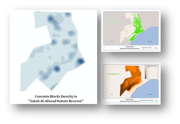
Supergeo Technologies, a leading global provider of GIS software and solutions, supports Public Authority for Agriculture and Fish Resources (PAAF), Kuwait to build a GIS platform, helping with the remediation actions in the military fortifications in Kuwait.
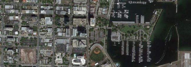
For a desert country like Kuwait, developing agriculture is a difficult job, especially the area surrounded by military constructions. Sabah Al-Ahmad Nature Reserve is one of the affected sites by the remains of more than 240,000 military fortifications at the north of Kuwait Bay. For remediating the damaged area, PAAF cooperates with International Integrated Environmental Services Ltd (IIES), Supergeo Platinum Reseller in Kuwait, to collect field data and set up the enterprise GIS database for military fortifications, concrete blocks and other components.
The main establishments of the project are to utilize survey methodologies, high resolution satellite images and GIS-based software packages to accomplish the objectives. The needed field data is captured through SuperPad, the professional GIS application, and synchronized to SuperGIS Desktop to process, analyze and produce various kinds of map to meet different demands. And then, the project manager can publish satellite images and the GIS layers via SuperGIS Server on the website.
With SuperGIS total solutions, all current and historical attributes for field operations such as vegetation cover, military fortifications, drainage system, Surface sediments, etc., can be perfectly managed and edited by different focused software applications.
For example, through SuperGIS Biodiversity Analyst, users can produce Biodiversity Geo-Atlas to manage images and information of plants, animals, species, and vegetations for determining the usage of a zone wisely.
This project successfully integrated and analyzed huge data to overcome the nature limits and artificial damages in Kuwait. Its outstanding performance also won SuperGIS Application Excellence Award. The Awardee, Public Authority for Agriculture and Fish Resource, Kuwait will receive the Award during the Conference of Discover GIS in Salwa Hall, Kuwait by Supergeo.
# # #
About Supergeo
Supergeo Technologies Inc. is a leading global provider of GIS software and solutions. Since the establishment, Supergeo has been dedicated to providing state-of-the-art geospatial technologies and comprehensive services for customers around the world. It is our vision to help users utilize geospatial technologies to create a better world.
Supergeo software and applications have been spread over the world to be the backbone of the world’s mapping and spatial analysis. Supergeo is the professional GIS vendor, providing GIS-related users with complete GIS solutions for desktop, mobile, server, and Internet platforms.
Read More »
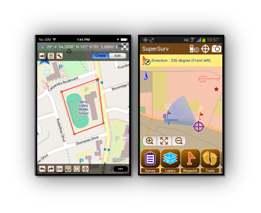
Smart Mapping SuperSurv Available on App Store and Google Play Now
Supergeo Technologies, a leading global provider of GIS software and solutions, launches SuperSurv, the mobile GIS app, on the App Store and Google Play. Containing comprehensive GIS data collection functions, SuperSurv is now more accessible for global users.
Designed for both iOS and Android powered devices, SuperSurv integrates with GIS and GPS technologies to provide rich functions in field survey, like Map Display, Query, Measure, etc. With SuperSurv, the collected data can be saved as feature layer (point, line, polygon) in SHP or GEO format in offline mode. Besides, SuperSurv supports to employ OpenStreetMap as the base map to make field survey more effective.
With the powerful and user-friendly GIS data collection functions, SuperSurv has been successfully applied in various industries worldwide, like environment protection, pollution prevention, facility management, etc. The free trial version is now available on Apple App store and Google Play, allowing users to experience complete functions within 7 days. The complete version can be purchased on Apple App Store and Google Play as well.
For users in North America, Supergeo especially releases SuperSurv M3 version to provide easy-to-use and useful data collection and map display functions. SuperSurv M3 supports feature layer display and offline editing functions. Furthermore, cached maps can be adopted as the base map to facilitate data capture tasks. Users in North America can find SuperSurv M3 on Google Play and App Store.
SuperSurv (iOS)
# # #
About Supergeo
Supergeo Technologies Inc. is a leading global provider of GIS software and solutions. Since the establishment, Supergeo has been dedicated to providing state-of-the-art geospatial technologies and comprehensive services for customers around the world. It is our vision to help users utilize geospatial technologies to create a better world.
Supergeo software and applications have been spread over the world to be the backbone of the world’s mapping and spatial analysis. Supergeo is the professional GIS vendor, providing GIS-related users with complete GIS solutions for desktop, mobile, server, and Internet platforms.
if";mso-fareast-font-family:新細明體;mso-bidi-font-family: "Times New Roman";mso-font-kerning:1.0pt;mso-ansi-language:EN-US;mso-fareast-language: ZH-TW;mso-bidi-language:AR-SA'>
Read More »Supergeo Establish User Network with Evolving Geosystems in UAE
Supergeo Technologies, a leading global provider of GIS software and solutions, announces the official reseller agreement with Evolving Geosystems Technologies (EGT) to keep providing high-quality total SuperGIS solutions in UAE.
Located in Dubai, EGT provides sophisticated GIS solutions, analysis, turnkey systems, custom applications, and technical support for government sectors, higher educational institutes, and the enterprises focusing on oil and gas, utilities, defense, etc. The professional team at EGT can assist different groups in making better decisions with the abundant functions in SuperGIS.
Focusing on state of the art GIS technologies, Supergeo provides total GIS solutions which includes desktop, mobile, server and engine for general users and GIS developers. No matter project managers, GIS analysts, field surveyors or even non-GIS domain users, SuperGIS software’s user-friendly interface and powerful functionality are to maximize efficiency and minimize the costs.
SuperGIS comprehensive solutions have been used worldwide to meet the challenges and requests in diverse domains. The further collaboration with Middle Eastern enterprise, Evolving Geosystems Technologies, also encourages Supergeo to support advanced GIS for organizations and professionals in UAE.

# # #
About Supergeo
Supergeo Technologies Inc. is a leading global provider of GIS software and solutions. Since the establishment, Supergeo has been dedicated to providing state-of-the-art geospatial technologies and comprehensive services for customers around the world. It is our vision to help users utilize geospatial technologies to create a better world.
Supergeo software and applications have been spread over the world to be the backbone of the world’s mapping and spatial analysis. Supergeo is the professional GIS vendor, providing GIS-related users with complete GIS solutions for desktop, mobile, server, and Internet platforms.
Read More »
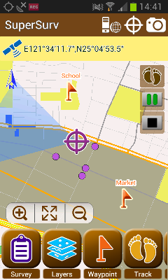
Android-Powered Mobile GIS, SuperSurv 3.1a, Supports Auto Positioning
Supergeo Technologies, a leading global provider of GIS software and solutions, announces that SuperSurv 3.1a for Android, the data collection app, now supports Auto Positioning to provide users with a more convenient and intuitive manipulation.
SuperSurv 3.1a is the mobile GIS app designed for field survey. The Android-powered app integrates with GIS and GPS technologies and provides rich functions like Map Display, Query, Measure, etc, for field surveying. In offline mode, users may edit and save point, line and polygon data directly with GPS. Going online, users may apply online maps and synchronize data in the server side.
To improve field survey performance, SuperSurv 3.1a now comes with Auto Positioning function. Through the new function, users can have map and GPS position refreshed automatically while moving with a certain distance in the field, such as GPS tracklog recording.
In this way, the map in SuperSurv can be refreshed with the GPS position remaining in the map center, allowing users to easily comprehend their position without manually panning maps all the time, significantly increasing the user friendliness and convenience.
On the other hand, to provide complete mobile solutions for iPad and iPhone users, SuperSurv for iOS is also available on the App Store. In addition, especially designed for the users in North America, SuperSurv M3 edition is now on the Google Play and App Store, for the surveyors looking for basic but necessary GIS functions for field survey.
# # #
About Supergeo
Supergeo Technologies Inc. is a leading global provider of GIS software and solutions. Since the establishment, Supergeo has been dedicated to providing state-of-the-art geospatial technologies and comprehensive services for customers around the world. It is our vision to help users utilize geospatial technologies to create a better world.
Supergeo software and applications have been spread over the world to be the backbone of the world’s mapping and spatial analysis. Supergeo is the professional GIS vendor, providing GIS-related users with complete GIS solutions for desktop, mobile, server, and Internet platforms.
Read More »
Comsoft Paris Uses SuperSurv 3 to Extend Enterprise Solutions
Supergeo Technologies, the leading global provider of complete GIS software and solutions, announced that Comsoft Paris selected SuperSurv, the data collection app for Android and iOS platforms, to extend business solutions and service ranges.
Collaborating with Géo.RM, Supergeo reseller in France, Comsoft has more than 23 years experience in providing professional software counseling. The products range widely from top designers of diverse domains, including antivirus, drawing, compiler, backup, which could be largely applied to health care, education, business, and other fields. The software expert selects SuperSurv to strengthen their provision.
SuperSurv 3 is the professional surveying application suitable for Android and iOS powered devices. With supreme geospatial data collection functions, users are able to efficiently gather needed information, and timely share accurate data with SuperGIS Desktop and SuperGIS Server for more applications.
As the leading GIS software, SuperGIS series products are utilized comprehensively in different countries and various application domains, to support professionals in daily GIS tasks. The success application by Comsoft could not only extend European markets for Supergeo, but also spread GIS software from geospatial industry to general business uses.
# # #
About Supergeo
Supergeo Technologies Inc. is a leading global provider of GIS software and solutions. Since the establishment, Supergeo has been dedicated to providing state-of-the-art geospatial technologies and comprehensive services for customers around the world. It is our vision to help users utilize geospatial technologies to create a better world.
Supergeo software and applications have been spread over the world to be the backbone of the world’s mapping and spatial analysis. Supergeo is the professional GIS vendor, providing GIS-related users with complete GIS solutions for desktop, mobile, server, and Internet platforms.
Read More »
Fulcrum Mobile Data Collection: Version 2.0 for iOS
Over the last few months, we’ve been working hard to bring Fulcrum for iOS to the next level, making data collection even faster and more powerful. The app has been rebuilt from the ground up with tons of features and improvements all around, as well as a whole new refreshed look and feel.
What's new in 2.0
High Resolution Satellite Layer from Google
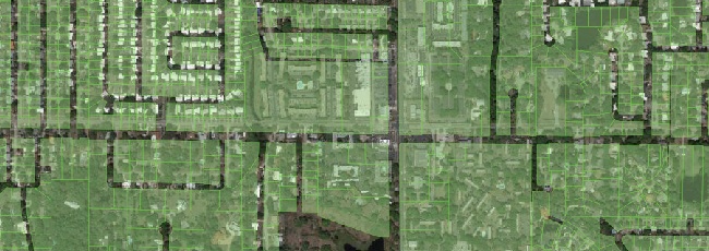
First up, we’ve added additional layers to give you access to high-resolution imagery data while in the field. Google’s Satellite and Hybrid views provide enormous levels of detail for places all over the world. Google’s expansive imagery database will give even rural and remote users access to quality imagery while on the go. The available imagery improves all the time.
Support for Overlay Layers
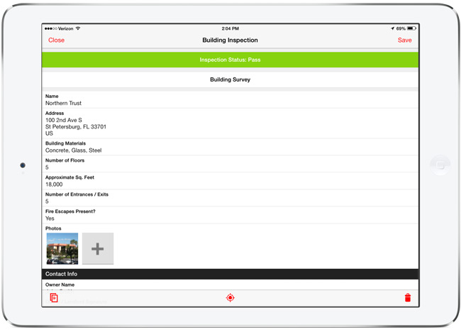
Upload overlay layers to use for reference while in the field. Datasets like parcel data, boundaries, routes, and other GIS layers can provide context and assistance for field data collection. These can now be added to the mobile app to view on top of imagery or other online layers. Building overlays is simple to do in TileMill, using one or a few GIS data layers (or raster layers). If you create a map with a transparent background, export to MBTiles format, and load into Fulcrum, the layer can be shown or hidden on top of the online basemap. This allows you to do things like build overlays of parcel data (like in the above screenshot), and overlay that onto the satellite imagery as a reference. Handy for all sorts of purposes.
Fullscreen Editing on iPad
The form editing interface on the iPad has been modified to run in a full screen view, taking advantage of the larger tablet display for ease of use. This is gorgeous, and makes filling out detailed forms much easier, giving you more room for typing and data entry.
There are dozens of other small improvements all over in 2.0. Here are just a few highlights of other changes:
- Better Photo Settings - Control the size of photos to optimize upload speeds. You can now set low, medium, high, and full size native photo sizes to use with Fulcrum.
- Record search improvements - We’ve improved the search capability to navigate to data from the mobile app. Accessible right from the main screen, this will run a full-text search through the data on your mobile device.
- Filter data by project or status - Filters help to trim down the total records shown on the screen, speeding up access to the data you need to work on.
If you’ve already have Fulcrum on your device, the 2.0 version will show up as an update, or will automatically update if you have auto-update enabled in iOS 7. The 2.0 release of Fulcrum is a major improvement, and we’re looking forward to hearing how it helps improve field data collection needs with its new features and functionality.
Get the app from the iOS App Store.
Read More »