Here’s the recent geonews in batch mode. On the open source / open data front: This is a must see, full instructions to Creating 3D terrains with Cesium Via O’Reilly, I became aware of Google’s open Material Design Icons on GitHub that can certainly be used for maps, reminiscent of the Maki and WorldWeatherSymbols amongst a few New lab, University ...
Read More »Tag Archives: open source
“Introduction to GIS” Course in English free of charge
The gvSIG-Training e-Learning platform opens its registration period for the “Basic GIS with gvSIG” MOOC in English, given by the gvSIG Association and GISMAP. This MOOC aims to show the use and potentiality of the open source software gvSIG in performing the most common operations during the workflow in a GIS environment. This Course is addressed to beginners as well ...
Read More »Webbrowser: Save maps for offline usage - Opensource solution
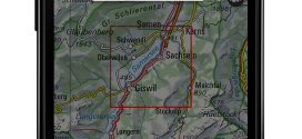
map.geo.admin.ch : now with offline function for usage in areas without network coverage Accessing maps in areas without network coverage is now possible with the map viewer of the federal geoportal, map.geo.admin.ch. A new function allows the download and local storage of a predefined map extent for offline usage. This new feature will meet the needs of individual users and ...
Read More »Versio: Distributed Version Control for Spatial Data, and GeoGig News (formerly GeoGit)
Spatial data versioning is important to lots of geospatial applications. We mentioned GeoGit (now named GeoGig) quite a few times. This week Boundless announced a private beta (you can request an invitation) of Versio, a website for distributed version control of spatial data. First, you may want to see how GeoGig (formerly GeoGit) has matured, it’s open source ...
Read More »Slashgeo is a proud media partner of FOSS4G-Asia
We are happy to inform you that Slashgeo will be a proud media partner of the upcoming Free & Open Source Solutions for GIS (FOSS4G) - Asia conference held in Bangkok, Thailand, 2-5 December! FOSS4G-Asia aims to bring together FOSS4G users and developers worldwide and foster closer interactions with and amongst Asian communities in order to ...
Read More »map.geo.admin.ch wins prize for the use of open source software

Out of 23 applicants map.geo.admin.ch received the Open Source Software Award. The prize was awarded by the Swiss Open Systems User Group / ch / open on October 8. The implementation of the geoinformation act based on the consequent adoption of open source software, open standards and cloud was rewarded. The innovative use of currently available technical possibilities ...
Read More »Batch Geonews: Book of OpenLayers 3, 30m Worldwide DEM, U.N. Guide to GeoStandards, and much more
Here’s the recent geonews in batch mode, covering most of September up to today. On the open source / open data front: It’s there now, announcing the release of The Book of OpenLayers 3 Be ready, within a year we’ll have all SRTM-DEM Level-2 (30m) data for the whole world, NGA Releases Hi-Res Elevation Data Here’s the Heron Mapping Client, ...
Read More »GeoServer 2.6.0 Released
One of the popular geospatial data server just got an update, GeoServer 2.6.0 has been released. Here’s an exhaustive list of talks on GeoServer at FOSS4G. The new features, according to the announcement: WFS Cascade: WFS Cascade has been updated to use a brand new GeoTools wfs client implementation. Curve support for GML and WMS: GeoServer curve support has ...
Read More »FOSS4G Wrap-Up
FOSS4G took place 2 weeks ago and here’s what you should not miss. First, if you’re like me and you couldn’t make it on-site this year, rejoice, all the FOSS4G sessions have been recorded and are available for free. Here’s the schedule to pinpoint all the talks you want to see, then, once you’re convinced there’s way too many ...
Read More »HALE 2.9.0 Released – new look, new tools, new INSPIRE Annex II/III support
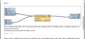
HALE 2.9.0 released – new look, new tools, INSPIRE codelists + Annex II/III The HUMBOLDT Alignment Editor (HALE) is a spatial data transformation application licensed unde LGPL. You use HALE to interactively and visually define and execute schema mappings and data harmonisation processes. We have just completed testing and documentation for the new HALE 2.9.0 release. There is a lot ...
Read More »