The pycsw team announces the release of pycsw 1.10.0.The 1.10.0 release brings significant features, enhancements and fixes to the codebase, including: support OGC OpenSearch Geo and Time Extensions standard support for Open Archives Initiative Protocol for Metadata Harvesting (OAI-PMH) support spatial dateline queries better support for geospatial links via the Python geolinks library fix CSW harvesting to harvest full records ...
Read More »Tag Archives: open source
FOSS4G: Live Stream, Birds of a Feather, Map Gallery, Parties - and more
September 5, Portland, Oregon, USA Live Stream, Birds of a Feather, Map Gallery, Parties - and more Updated schedule and conference live stream The schedule [1] has been updated with the latest details and is full of great workshops, presentations, and events. Take a look and start sketching out your conference now to ensure that you don’t miss any crucial ...
Read More »Batch Geonews: OpenStreetMap Contributions, QGIS Cloud, Google ‘The Cartographer’, O’Reilly Book, and much more
Here’s the latest geonews in batch mode. On the open source / open data front: Ready for FOSS4G, the geospatial open source software collection named OSGeo-Live 8.0 has been released Pictures tell you everything, OpenStreetMap contributions around the world Informative charts, The OpenStreetMap Contributor Activity Report – Edition We mentioned QGIS Cloud two years ago, here’s an entry ...
Read More »OpenLayers 3.0 Released
This is major news. The open source OpenLayers library is one of the most widely used web mapping software. After a complete overhaul of the venerable 2.x branch, OpenLayers 3.0 has been released. From the announcement: “This release includes a ton of new features such as an easier to use API as well as improved vector rendering and image manipulation. […] ...
Read More »Batch Geonews: Google Drone Delivery, Galileo Satellites Failures, 100 New 3D Cities for Bing Maps, 1M NYC Buildings in OSM, and much more
Here’s the recent geonews in batch mode. On the open source / open data front: A webinar Friday next week named Introducing the QGIS Academy Project Nice to see, Over 1 million New York City buildings and addresses imported to OpenStreetMap Because that’s the kind of maps we want to show our friends, Showing geotagged photos on a Leaflet map ...
Read More »FOSS4G: Extracurricular adventures, don’t forget the Map Gallery, and schedule updates
August 19, Portland, Oregon, USA Extracurricular adventures, don’t forget the Map Gallery, and schedule updates Your registration is paid (what? not yet? register now! [1]), your bags are near-packed, and now you’re wondering what else to do in Portland — in addition to a fantastic week of development, networking, and geo-geek revelry. See below for things you map have ...
Read More »Open Source / Data Geonews: the 10 Years of OpenStreetMap adn Related News, WebGL Earth 2, and much more
Still catching up the geonews that showed up during our holiday break, here’s the open source / open data geonews in batch mode. Open source geospatial software: Desktop virtual globes on their way out? Here’s WebGL Earth 2, “Open-source virtual planet web application running in any web browser with support for WebGL HTML5 standard” There’s Geocolor that we haven’t mentioned ...
Read More »10th International gvSIG Conference: “Strategies for the 21st Century”
The 10th International gvSIG Conference, organized by the gvSIG Association, will be held from December 3rd to 5th at La Petxina Sports-Cultural Complex (Valencia - Spain), under the slogan “Strategies for the 21st Century”. Call for papers is now open. As of today communication proposals can be sent to the email address: they will be evaluated by the ...
Read More »Cesium 3D Web Mapping Library 1.0 Released
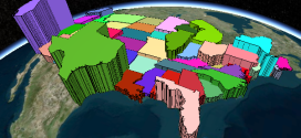
Cesium is an open-source JavaScript library for creating 3D and 2D web maps. It uses WebGL for hardware-accelerated graphics. Version 1.0 includes support for worldwide high-resolution terrain; global imagery from standards such as WMS, OpenStreetMap, Bing Maps, and ArcGIS MapServer; vector data from GeoJSON and TopoJSON; 3D models using glTF; and a large geometry library.
Read More »Open Source Geonews: Leaflet Tips and Tricks, QGIS MOOC, ArcGIS vs Open Source, FOSS4G Program, and more
Here’s the recent open source and open data geonews. On the software front: A new version, OpenGeo Suite 4.1 released Updated QGIS plugin for Semi-Automatic Classification Plugin v.3.0 “Rome” released OL3 is not with us yet, but that doesn’t mean we can’t have Editing in OpenLayers 3 using WFS-T Here’s to create Toner-lite styles for QGIS, similar to the ones ...
Read More »