The gvSIG Association announces the publishing of the gvSIG 2.1 final version. This version, that is the first one based on the new architecture oriented to users, has a lot of new features as you can see now. Besides the new functionalities and the correction of a great number of errors that have been detected thanks to the community collaboration, ...
Read More »Tag Archives: software
Turf: New Open Source WebGIS
We begin year with pretty interesting and major news. WebGIS is one giant step closer to be seriously useful, thanks to the new open source WebGIS project named Turf. From the MapBox announcement: “Turf is GIS for web maps. It’s a fast, compact, and open-source JavaScript library that implements the most common geospatial operations: buffering, contouring, triangular irregular networks ...
Read More »FOSS4G-Asia: MapMint
MapMint was presented this Tuesday in a workhop at FOSS4G-Asia. Gerald Fenoy shows some of MapMint features such as publish web service and produce map applications by using an administration interface without any complex lines of code. This project is built on top of MapServer (using a modified version), MapCache, Zoo Projects (WPS), OpenLayers, JQuery and GDAL-OGR. It can be used for ...
Read More »GraphHopper: a fast and flexible open source trip planner
Route planning is an essential part of the connected and mobile world. Many people use commercial solutions on a daily basis to avoid traffic jams when heading home or when they plan their next business or outdoor trip. It is also a crucial part in many business areas like for garbage collection, pizza delivery, or ride sharing where speed is ...
Read More »QGIS 2.6 Released
QGIS is amongst the most featureful open source desktop GIS out there, it just got better this week with the release of QGIS 2.6 ‘Brighton’. The visual changelog offers a long description of the new features and improvements. Here’s the index, please follow the link to read the details and see the accompanying screenshots: General Feature: Project filename in properties ...
Read More »Versio: Distributed Version Control for Spatial Data, and GeoGig News (formerly GeoGit)
Spatial data versioning is important to lots of geospatial applications. We mentioned GeoGit (now named GeoGig) quite a few times. This week Boundless announced a private beta (you can request an invitation) of Versio, a website for distributed version control of spatial data. First, you may want to see how GeoGig (formerly GeoGit) has matured, it’s open source ...
Read More »GeoServer 2.6.0 Released
One of the popular geospatial data server just got an update, GeoServer 2.6.0 has been released. Here’s an exhaustive list of talks on GeoServer at FOSS4G. The new features, according to the announcement: WFS Cascade: WFS Cascade has been updated to use a brand new GeoTools wfs client implementation. Curve support for GML and WMS: GeoServer curve support has ...
Read More »Huellasolar launches its OpenPlatform, an online environment to build radiation and sun exposure maps of cities and projects.
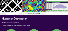
Huellasolar opens its system and offers tools to be used for designers, companies, institutions, architects, engineers, students etc. along the world to build radiation maps of their cities or projects. Generated maps are displayed and shared online thorugh a specifically designed viewer including a lot of features to analyze and get data from the model Monthly and hourly radiation and ...
Read More »FOSS4G Wrap-Up
FOSS4G took place 2 weeks ago and here’s what you should not miss. First, if you’re like me and you couldn’t make it on-site this year, rejoice, all the FOSS4G sessions have been recorded and are available for free. Here’s the schedule to pinpoint all the talks you want to see, then, once you’re convinced there’s way too many ...
Read More »HALE 2.9.0 Released – new look, new tools, new INSPIRE Annex II/III support
HALE 2.9.0 released – new look, new tools, INSPIRE codelists + Annex II/III The HUMBOLDT Alignment Editor (HALE) is a spatial data transformation application licensed unde LGPL. You use HALE to interactively and visually define and execute schema mappings and data harmonisation processes. We have just completed testing and documentation for the new HALE 2.9.0 release. There is a lot ...
Read More »