Tag Archives: Street View

Google Geonews: Biggest Street View Update, New GM Tracks API and GM Geolocation API, GM for iOS Alpha, and more

Here's the recent Google-related geonews.

From official sources:

  • Google made their biggest Street View update ever: "[...] doubling our number of special collections and updating over 250,000 miles of roads around the world. We’re increasing Street View coverage in Macau, Singapore, Sweden, the U.S., Thailand, Taiwan, Italy, Great Britain, Denmark, Norway and Canada. And we’re launching special collections in South Africa, Japan, Spain, France, Brazil and Mexico, among others."
  • There's expanded coverage of building footprints in Google Maps: "25 million new building footprints that have been added to Google Maps"
  • The Dev blog introduces the Google Maps Tracks API and the Google Maps Geolocation API:
    • Google Maps Tracks API allows an organization to build applications that can store, display and analyze GPS data on a map.  The API is built on top of Google’s reliable cloud infrastructure and offers specialized features such as geo-fencing.
    • Google Maps Geolocation API enables an application or device to determine its own location without the use of GPS by looking up the locations of nearby wifi access points and cell towers. By limiting GPS usage, a device can save battery life and work indoors or in remote areas.
  • Here's Street View inside Google's data centers

From other sources:

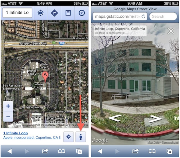
  • Here's early screenshots of Google Maps for iOS in alpha testing
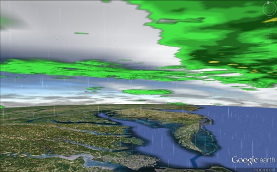
  • The GEB tells about weather in Google Earth
  • And of course, there was the expected satellite imagery update

Read More »

Google Geonews: Street View in Mobile Browsers, Google Maps API Gallery, and more

Here's the recent Google-related geonews in batch mode.

From official sources:

  • Google announced Street View comes to Google Maps on your Mobile Browser: "Starting today, use Street View on your mobile browser to check out a new shop across town or get a feel for the ambiance at a restaurant before you arrive. To use Street View on your mobile browser simply go to maps.google and search for a location. Then click the “pegman” icon at the bottom right of your screen to access Street View."
  • Google also launched MoreThanAMap to showcase uses of the Google Maps API
  • Google's Ed Parson chimes in on the Apple Maps woes: "[...] the bigger issue is the lack of a true geocoded search index of places and the search algorithms that sit around it. Local search is in many ways what makes smart phones smart, because the users location and the location of things around them provides a set of contextual pointers to relevant information."
  • There's traffic estimates now available for enterprise customers in the Google Maps API
  • Yes, there's new imagery, including new 45deg imagery for 51 cities

From other sources:

  • Slashdot ran a discussion named Google Glass, Augmented Reality Spells Data Headaches, with Google Glass being the topic of our current poll (right hand side column)

Read More »

Google Geonews: Google and Apple Maps, Street View Goes Underwater, Many Data Updates, and more

Please allow the recent silence, busy week, I should be able to catchup next one. Here's the recent Google-related geonews.

Regarding Google and Apple Maps:

  • MacRumors claimed that Apple's Split with Google Over iOS Maps Driven by Turn-by-Turn Navigation Dispute, that Google's Work Toward Standalone iOS Maps App Complicated by Integration with Google Earth and apparently, Apple Reportedly Had Over a Year Left on Maps Contract with Google
  • Slashdot discussed Apple Reportedly Luring Ex-Google Mappers With Jobs

From official sources:

  • Google Maps now offers underwater imagery, a topic discussed by Slashdot in Google Captures 'Street View' of Underwater Habitats
  • Street View reaches other new places, introducing Imagery of Chile and Croatia on Google Maps, and Andorra too
  • Google Maps for Android has been updated, and you get all your Google Maps searches in one place
  • Live Road Traffic Launches in 3 New Countries, in three new cities: Jeddah, Saudi Arabia; Kuwait City, Kuwait and Guayaquil, Ecuador
  • Your can now explore the great indoors of France with Google Maps for Android

From other sources:

  • Slashdot discussed California Legalizes Self Driving Cars, and to my knowledge, Google is leading the way the car's future
  • Here's Geoception, a new Google Earth-based game: "In a nutshell, you command and control a fleet of combat drones to provide local and regional security, eventually taking over the whole world."
  • The GEB also offers an entry named Cambodians fighting malaria with SMS and Google Earth
  • And yes, there was another imagery update
Read More »

The City of Malmö creates new opportunities with BlomSTREET™ technology


Blom has successfully captured over 300,000 BlomSTREET™ single street view images for The City of Malmö, Sweden.

"The City Planning and Road Department currently use the imagery in their operations, but we envisage that all departments will soon benefit from this versatile product ", says Allan Almqvist, city engineer for the City of Malmö.

BlomSTREET™ - powered by Cyclomedia, is captured from ground level, resulting in a comprehensive, high resolution and georeferenced library of 360-degree panoramic images developed for professional users. The data is provided with an easy to use software package that enables 3D measurements and visualization of 2D and 3D information directly from the imagery.

Allan Almqvist discussed Malmö’s reasoning for choosing BlomSTREET™ - “The Blom product provides many advantages over other commercially available street view imagery. Blom has provided the tools to integrate BlomSTREET™ into our general mapping portal, Malmö City Atlas. This means that all of our geographical data is visible within the same system, combining with our existing maps, orthophotos, oblique images and now street views. This vastly reduces training costs and makes it extremely easy for any of our employees to use the data.” adds Allan Almqvist.

This technology has been developed by CycloMedia and the data capture is performed by Blom using two cameras and a GPS (Globally Positioning System) mounted on the roof of a specially adapted car.

"The benefits of BlomSTREET™ are that we have full control over the frequency of capture and which streets or bicycle paths we choose to photograph. Measurement functions, metadata and the ability to add vectors directly on to the BlomSTREET™ imagery are all key elements of the products“, concluded Allan Almqvist.

Jens Ekander, an architect at Malmö City uses BlomSTREET™ every day.
"Visualisation and measurements are often required to build an understanding of an existing site. So by using BlomSTREET™ I can quickly get a feel for a house or a street without the need to visit the location. For me Blom’s imagery is a great help".

Another frequent BlomSTREET™ user is Peter Ahlström, GIS Engineer at Malmö City. "Because the imagery has such a high resolution it’s very helpful in multiple situations to interpret orthophotos and field sketches. I also use the imagery for updating the primary maps, which serves as verification when I edit data from field measurements. I also make additional measurements myself, so it gives me the opportunity to see what it looks like on the ground and can therefore act as quality control"

BlomSTREET™ is available through our BlomWEB Viewer™ and BlomDESKTOP Viewer™, or alternatively via our API. For more information about BlomSTREET™, contact your local Blom office. 


Read More »

Google Geonews: Biking Directions on Android, Map Maker and Street View Updates, and more

Slowly starting to catch up mid-August geonews, here's the associated recent Google ones.

From official sources:

  • Bikers rejoice, biking navigation in 12 countries in Google Maps for Android: "That’s why today we’re bringing mobile biking directions and navigation to the 10 countries [...]. Plus, we’re adding turn-by-turn, voice-guided biking navigation to Google Maps Navigation (beta) in every country with biking directions."
  • There's Map Maker updates for Lesotho, Oman and Trinidad & Tobago and Detroit, Michigan
  • Street View:
    • Google Maps and Street View are going to Canada's far north
    • Street View is also much improved in Brazil and prehispanic Mexican cities
    • You can See Rebuilding in New Orleans Through Updated Street View Imagery
  • As a public transport daily user, I'm happy that Google Maps now has schedules for more than one million public transit stops worldwide
  • We did mention geo-wiki last February, and now Google shares an entry named Validating Land Cover Datasets with Geo-Wiki, using a blend of Google tools and open source ones (e.g. MapServer, PostGIS)

From other sources:

  • The GEB links to 'A New Life' new country generator in Google Earth for use in education and fun
  • APB mentioned Google acquired 7 deCarta LBS patents
  • There's still much left to discover on this planet, New Egyptian pyramids found using Google Earth?
  • There's Mars' Curiosity rover imagery in Google Mars now
Read More »

Batch Geonews: London Olympics Maps and more, Project Geo, MapPoint, Global Arms Trade, and much more

Here's the recent geonews in batch mode.

On the London Olympics:

  • Here's on the development of the London SuperMap
  • Microsoft shares Olympics bird's eye imagery and maps
  • Esri shares Olympics thematic maps on ArcGIS Online
  • In another entry, Using Esri Data to Find the Next Olympians – Part 1
  • DM shares links to other London Olympics maps
  • APB mentions telecommunication issues in an entry named Use of Twitter, Social Media Blamed for GPS Data Delay used in Olympic Bike Race Reporting

On the open source front:

  • If you're into vertical datums, VDatum 2.3.5 has been released (via Kurt)
  • OpenGeo tells us how Thematic map creation with SLD is now much easier with the new Recode, Categorize, and Interpolate functions support in GeoServer
  • New to QGIS, HTML map tips in QGIS

On the Esri front:

  • Here's GeoMobile for ArcGIS Online - A Free Mobile GIS App for Tablets
  • The Esri Map Book, Volume 27 now available
  • The Esri Ocean basemap color style available for download

On the Google front:

  • Google Map Maker is now available in Australia (and so is OpenStreetMap ;-)
  • Planned NYC subway changes are now in Google Maps
  • We now get the Kennedy Space Center in Street View for its 50th birthday
  • The iconic residence of the UK Prime Minister, Take a virtual walk in Downing Street
  • Via O'Reilly, strange images where 3d maps and aerial imagery don’t match up
  • Using Google Earth, GE Teach to receive a Geographic Excellence in Media Award
  • And there was an imagery update for 25 cities and 72 countries

On the Microsoft front:

  • Microsoft announced MapPoint Released
  • There's Expanded UK Transit Directions

A few geostories discussed over Slashdot:

  • US Census Bureau Offers Public API For Data Apps
  • ACLU Questions Privacy of License Plate Scanners
  • The Future of Project Glass (see our current related poll in the right-hand side column)
  • Defcon Researchers Build Tool To Track the Planes of the Rich and Famous
  • Detecting moving objects, Researchers Turn Home Wi-Fi Router Into Spy Device

In the everything else category:

  • The GEB mentions Project Geo, a new Google Plus Hangout web series dedicated to increasing awareness of Geospatial Technology, industry best practices, and GIS resources
  • The eoPortal wants us to know that their Events, Images and Job Opportunities sections are now updated and online

In the maps category:

  • Here's a really nice visualization of global arms trade
  • Here's a map of Melting and Mining in Greenland
  • Maps on the Global Geography of Coffee, Tea, and Yerba Mate
Read More »

Google Geonews: My Tracks 2.0, Biking Directions in Europe, Indoor Maps in Museums and in the UK, 11,000 Tours, and more

Here's the recent Google-related geonews. From official sources:

  • Google announced the release of My Track 2.0, the open source app on Android to generate GPS/GNSS tracks and share them in Google Maps and Google Earth
  • Biking directions in Google Maps expands to several countries in Europe and Australia, a topic also discussed on Slashdot
  • In the latest Google Earth for Android (and upcoming for iOS), they included a new tour guide feature for visual trips using the great new 3D imagery they are adding. There is 11,000 tours available covering 110 countries!
  • California's National Parks are now available in Street View
  • Walking directions made its way in Google Maps for Africa
  • In the latest Google Maps for Android, you now get indoor maps of 20 popular museums, added to the 10,000 other indoor maps they already provided
  • Related, there's an entry on going indoors at locations across the United Kingdom
  • There is new 45° imagery available for 31 cities including 26 cities in the U.S. and 5 international locations
  • Google also offers an entry on Map Makerpedia, their community tool for Google Map Maker (but you already know I prefer OpenStreetMap, for openness reasons)
Read More »

‘Google Maps Coordinate’ Launched and other Google-related Geonews

Here's the recent Google-related geonews in batch mode.

From the official sources:

  • Google introduced 'Google Maps Coordinate': "That’s where Google Maps Coordinate comes in, a new tool designed to improve communication between businesses and their employees in the field.  As the number of mobile employees continues to grow, so does the need for a location sharing solution that works in real-time.  Research firm IDC estimates that there will be over 1.3 billion mobile workers by (37.2% of the total workforce). Google Maps Coordinate combines the power of Google’s mapping technologies with modern smartphones to help organizations assign jobs and deploy staff more efficiently." See introduction video below.
  • There is traffic conditions in 7 new countries and updates in 19 existing ones: "Belarus, Estonia, Latvia, Mexico, Peru, Romania and South Africa"
  • Google Map Maker (which always makes me think of OpenStreetMap...) is now available in 8 new countries: "Austria, Belgium, Denmark, Liechtenstein, Luxembourg, Netherlands, Norway, and Switzerland"
  • Street View is now available in Hawaii

From other sources:

  • DM shares an article named A Use Case: Google’s Cloud-based Earth Builder: "Rod Erickson of Next Tier Concepts provides provides a solution using Software-as-a Service (SaaS)."
  • APB mentions Google’s Peer to Peer Location Determination Patent Application
Read More »

Batch Geonews: GeoPublisher and AtlasStyler 1.9, Ten Things about GPS, MapInfo Pro 11.5, and some more

Here's the recent geonews in batch mode.

From the open source front:

  • Along with new versions, here's the Geopublisher and AtlasStyler 1.9 release notes

From the Google front:

  • Slashdot discusses a story named After Modifications, Google Street View Approved For Switzerland
  • There was an imagery update on June 11th

Directions Mag articles:

  • An article named My Top 6 Takeaways from SQL Server Spatial
  • Another one named Ten Things You Need to Know About GPS, reminding us that often people use the GPS term while they really should use GNSS
  • Another one named Intergraph’s GIS Product Roadmap Comes Into Focus
  • And for Pitney Bowes, New Features for MapInfo Professional Version 11.5, and by the way, Facebook Is Using Pitney Bowes Software for Geocoding

In the miscellaneous category:

  • MacRumors summarizes the U.S. Location Privacy Protection Act
  • MapQuest released an all new MapQuest for iPhone app
  • Rumors that Microsoft is Going 100% with Nokia Mapping in Windows Phone 8
  • After Google, Microsoft jumps in the Augmented Reality future with rumored AR glasses for Xbox
  • Slashdot discussed a story named 64 Drone Bases Located On American Soil

In the maps category:

  • O'Reilly shared a map of global BitTorrent usage
Read More »

Batch Geonews: GeoExplorer, Google vs Apple Maps, Unmanned Aerial Systems, London Olympics, Tornadoes, and more

Here's the recent geonews in batch mode.

From the open source front:

  • OpenGeo runs an entry named Five things you didn’t know about GeoExplorer

From the major companies front:

  • I liked the Google vs Apple mapping discussion from Peter Batty: "Google announces that it is scared of Apple Maps
    [...] Now don't get me wrong, Google is the market leader and Apple has everything to prove."
    See also his entry named Apple Maps: Predictions and Questions, which are also of course innovations Google could implement. Viva competition! (well ok, I admit I prefer cooperation ;-)
  • James has an interesting entry named One Man's Disruptor is Another Man's Incumbent, the incumbents are Google Maps, MapQuest, Esri and Microsoft, and the disruptors are MapBox, Esri and Apple
  • Via O'Reilly, the connection between Google Street View and driverless cars: "Now, I’m realizing the biggest Street View data coup of all: those vehicles are gathering the ultimate training set for driverless cars." Read the comments, driverless cars data is not simple
  • There's 2 new modules for Bing Maps V7: GeoJSON and WKT reader/writer modules
  • The GEB discusses Using StreetView to validate 3D models

Discussed over Slashdot:

  • NASA Tool Shows Where Forest Is Being Cut Down
  • Autralian Mining Companies Increasing Use of UAVs
  • Cognitive Software Identifies America's Brainiest Cities
  • John Carmack Is Building a Virtual Reality Headset
  • Trained Rats Map Minefields With GPS

In the everything-else category:

  • The eoPortal shares an entry named US not losing its foothold in Earth observing satellites, only shifting power
  • The eoPortal also mentions a new imaging system produces 3D models of monuments using unmanned aircraft
  • On that very topic, DM shares an article named Ten Things You Should Know About Unmanned Aerial Systems (UAS)
  • VerySpatial have an informative entry on geospatial at the upcoming London Summer Olympics and U.K. in general
  • AR as entertainment of the future? Kinect and RFID power an augmented reality theme park (via OR)

In the maps category:

  • Here's a nice visualization of 56 years of tornadoes in the U.S.

As a bonus for reading till the end, here's a interesting quote: "If a picture is worth a thousand words, a map can be worth a thousand spreadsheets."

Read More »