Here’s the latest geonews in batch mode. On the open source / open data front: Ready for FOSS4G, the geospatial open source software collection named OSGeo-Live 8.0 has been released Pictures tell you everything, OpenStreetMap contributions around the world Informative charts, The OpenStreetMap Contributor Activity Report – Edition We mentioned QGIS Cloud two years ago, here’s an entry ...
Read More »Tag Archives: QGIS
Batch Geonews: Google Drone Delivery, Galileo Satellites Failures, 100 New 3D Cities for Bing Maps, 1M NYC Buildings in OSM, and much more
Here’s the recent geonews in batch mode. On the open source / open data front: A webinar Friday next week named Introducing the QGIS Academy Project Nice to see, Over 1 million New York City buildings and addresses imported to OpenStreetMap Because that’s the kind of maps we want to show our friends, Showing geotagged photos on a Leaflet map ...
Read More »Open Source Geonews: Leaflet Tips and Tricks, QGIS MOOC, ArcGIS vs Open Source, FOSS4G Program, and more
Here’s the recent open source and open data geonews. On the software front: A new version, OpenGeo Suite 4.1 released Updated QGIS plugin for Semi-Automatic Classification Plugin v.3.0 “Rome” released OL3 is not with us yet, but that doesn’t mean we can’t have Editing in OpenLayers 3 using WFS-T Here’s to create Toner-lite styles for QGIS, similar to the ones ...
Read More »QGIS 2.4.0 Released
Formerly known as Quantum GIS, QGIS is one of the most mature open source desktop GIS software. Over the weekend, QGIS 2.4.0 has been released and here’s the visual changelog. From the visual changelog’s introduction: “The emphasis on this release has been very much on polish and performance - we have added many new features, tweaks and enhancements to make ...
Read More »Batch Geonews: Municipal Datasets, 3DEP - 3D Elevation Program, more Transit in Google Maps, and much more
Here's the recent geonews in batch mode.
From the open source and open data front:
- Rezoning permits are #1, Open Data Summit Top 10 Most Wanted Municipal Datasets
- New open source tool, batyr: On-demand synchronization of vector data to a PostGIS database
- QGIS improvements the QGIS Field calculator is dead. Long live the Field calculator bar
- Something many end up doing, and here's a guide to do it, A guide to the rasterization of vector coverages in PostGIS
- An extension in development to make OpenLayers more powerful, CAD-like Feature Construction with the OpenLayers Editor
- Open data is everywhere, and any time! OpenHistoricalMap is a project designed to store and display map data throughout the history of the world
- GeoAwesome asks Should navigation companies move to OpenStreetMap like Telenav?
- Is a new website newsworthy? The new GeoServer website is certainly a nice improvement
- Getting closer to version 1.0, here's another summary of GeoGit - Distributed geospatial data versioning based on Git
- Geoff also shares a summary on the state of Canada's open geospatial data initiative
- On the American side, the NED DEM dataset will be replaced by 3DEP - 3D Elevation Program, offering always higher spatial resolution
From the Google front:
- Google provides an update on transit directions in Google Maps, including all transit routes in Great Britain and host cities in Brazil, real-time updates for Vancouver and Chicago, and more, also mentioning that transit is available in "64 countries and more than 15,000 towns and cities worldwide"
- At the beginning of the month, new Google Map apps added several new features, including Uber integration and an offline button for iOS
- The GEB shares Tips to make Google Earth appear more realistic and the screenshot is convincing and here's How the Google Earth cache works
- If you don't already know what those geometric structures are on the sea floor, Did Google Earth discover an underwater alien base?
- Want to understand El Nino? Everything about the El Nino Zone in Google Earth
- We told you about Project Tango already, Slashdot discusses Google Rumored To Be Making 3D-Scanning Tablets
- One article I missed published last month, in forestry, Google Earth Engine Brings Big Data to Environmental Activism
- And yes, here's the list of locations for this month's new Google Earth imagery
In the everything-else category:
- GeoJSON now an official media type registered with the IANA (IANA on Wikipedia)
- Over the Spatial Law site, an entry named White House Big Data and Privacy Report: Wake Up Call for Geospatial Community?
- At the research stage, ‘Quantum Compass’: Navigation technology that might replace GPS, this is also discussed over Slashdot
- Numbers to say it's worth, contribution of Geospatial Industry to Irish Economy in: E69.3m
- Interesting to see what is considered the Big 5 of geospatial: future cities, open geospatial, BIM, big data and policy, it's a series of events planned for next Fall
- Another free online course, Simon Fraser Professor Introduces GIS MOOC
- A short reminder of the potential of Augmented Reality and Geospatial Technology
- It's happening, Volvo Testing Autonomous Cars On Public Roads
- Privacy, US Police Departments Using Car Tracking Database Sworn To Secrecy
- But there's useful uses to tracking? Robbery Suspect Tracked By GPS and Killed
- Creating 'Swarm', Foursquare Splits To Take On Yelp
- Deeply into remote sensing? A new eNewsletter from the IEEE Geoscience and Remote Sensing Society
- The Proba-V mini-satellite, Views of Earth From Europe’s New Plant-Mapping Minisatellite
- I remember discussions about this 12 years ago, Canada might get its hyperspectral spaceborne mission, related press release
- Real-time tracking map of whales around Hawaii
In the maps category:
- Nice moon remote sensing, Help NASA Choose the Most Beautiful Lunar Image
- Less nice is ESA's Cryosat Mission Sees Antarctic Ice Losses Double
- Not useful, but there's something I like about the Worlds Capitals Voronoi map and why not, a Voronoi map of the world divided by airports
- A map according to languages, named by The Economist as The world according to Putin
- One of my favorite topics, Interactive map shows global economical inequality
- Let's end with funny maps, Slicing Europe with 20 stereotypes
Batch Geonews: PyQGIS Book, More GeoGit, Android Wear, Sub-meter Bathymetry, Google Maps Supports GeoJSON, and much more
Here's the recent geonews in batch mode.
From the open source / open data front:
- FOSS4G announced their opening keynote speaker, Mike Bostock of D3.js fame
- This was published as a PR, Extending QGIS Just Got Easier with The PyQGIS Programmer's Guide
- In the same category, Book Review: PostGIS Cookbook
- 3D in open source GIS is getting to a nice state, 3D viz with QGIS & three.js
- Open source PGRestAPI, a Node.js REST API for PostgreSQL Spatial Entities
- New versions, GeoTools 11.0 released and so was OSGeo-Live 7.9
- News from GeoGit, GeoGit in Action: Distributed Versioning for Geospatial Data
- Interesting news from OL3, OpenLayers 3 Vector Rendering: Topology-Preserving Simplification
- OpenStreetMap and open data generate plenty of offsprings, from OpenSnowMap to OpenLoveMap
- And the question of the license is never fully closed, OpenStreetMap: Is share-alike restrictive for spatial data?
From the Esri front:
- Here the What’s New in ArcGIS Online (March)
- Esri announced Routing Enhancements to ArcGIS Online
- They are also Introducing the Find, Edit, and Filter app for ArcGIS Online
From the Google front:
- Wearables are inherently geospatial, I make links between the new Android Wear project and this O'Reilly article named Wearing the future
- Google Maps now supports GeoJSON, Maps made easier: GeoJSON in the JavaScript Maps API
- A followup on a previous story, Hands On: Project Tango, Google’s 3D-Scanning Phone for Makers, also, Google's Project Tango Headed To International Space Station
- An upcoming webinar named Combining Google Maps and Google Search to Empower Decision Making
- Embedding Google Maps, Adding the new Google Maps to your website just got easier with the new Google Maps Embed API
- There's a lot to love with the new Google Maps, but GeoAwesomeness shares 4 things I hate about new Google Maps
- Ok, if you have some free time, here's a nice game to discover the world, guess where the StreetView you're shown actually comes from with GeoGuessr
- New data, Explore America’s most endangered river on Street View and Hawaii too, Aloha from Google Street View
- Drown your town, Using Google Earth to predict sea level rise
- Art and map content gives us Art from infrastructure: the art of Google Maps
Geo-related discussions over Slashdot:
- An open discussion on the Easiest To Use Multi-User Map Editing?
- You car is being tracked, Vast Surveillance Network Powered By Repo Men
- Still on privacy, Cops Say NDA Kept Them from Notifying Courts About Cell Phone Tracking Gadget
- It could have been another service, Using Google Maps To Intercept FBI and Secret Service Calls
- The Navy too, Navy Database Tracks Civilians' Parking Tickets, Fender-Benders
- And why not track all cars? L.A. Police: All Cars In L.A. Are Under Investigation
- Visualization, Key Routes and Communities In London's Bike Rental Network
- For now, Using Handheld Phone GPS While Driving Is Legal In California
In the everything else category:
- We mentioned a few times iBeacons, here's you chance to catch up, O'Reilly publishes an article named iBeacon basics
- Bing Maps Developers blog is shut down, what does this say about Microsoft's interest in mapping technologies?
- The father of GIS died, and it's time from an history lesson with this entry named Geospatial computerization in the 1960s: The Canada Land Inventory
- For yourself or colleagues? Another open geospatial course, Skills for the Digital Earth, Open for Registration
- I have failed to make it work, but it's based on Leaflet and MapBox, a new virtual globe AtomJump Javascript 3D Earth API
- While not under Google's wings anymore, it is still alive and well, SketchUp and a refreshed 3D Warehouse released
- MapBox, one of the popular geoenterprises, is Launching Mapbox Enterprise, which is essentially the same great MapBox services for aimed at large clients
- Indoor mapping being revolutionized, Wired's We Mapped Our Boss’ Office With This Slick New 3-D Camera
- Indoor mapping is a la mode, TomTom enters “Indoor”
- Tablets and geospatial; First app for LiDAR data visualisation on iPad
- Routing challenges, Helsinki’s personalized bus service is like Uber for public transit
- Talking of transit, Apple Maps to Include Transit Directions, Improved Points of Interest Data in iOS 8
- There's the 17th AGILE Conference on Geographic Information Science next June in Spain
- A Spatial Law perspective on UAVs in the US
- Meanwhile, more EO satellites gets into space, Planet Labs' Flock 1 comprised of 28 Earth observation Cubesats deployed from ISS
- Bathymetry? Worth a look, Satellite-derived bathymetry at sub-meter level from EOMAP and Satrec Initiative
In the maps category:
- This MapBox overlay is pretty nice, Global Elevation Data on Satellite Imagery
- A map of solar time vs clock time for each timezone, How Wrong Is Your Clock?
- Hungry? Country maps made of food
Extending QGIS Just Got Easier with The PyQGIS Programmer’s Guide
Locate Press LLC, March 10 - Locate Press is pleased to announce the release of The PyQGIS Programmer's Guide in both paperback and PDF formats.
PyQGIS, the blending of QGIS and Python, provides the means to extend and enhance the functionality of QGIS by writing scripts and plugins to implement new features and perform automated tasks.
The PyQGIS Programmer's Guide makes getting started with QGIS customization easy. After a brief introduction to Python, the guide moves on to cover the QGIS Application Programmer Interface (API), writing and running scripts, building a plugin, and writing a standalone application.
An extensive chapter on Tips and Techniques is included, providing examples of common tasks encountered while developing with PyQGIS.
The book is designed with examples and exercises to aid in mastering PyQGIS while providing an enhanced learning experience. All code used in the book is freely available from the website.
The PyQGIS Programmer's Guide is compatible with QGIS version 2.x releases.
###
Read More »Batch Geonews: Predictions, Near Real-Time Imagery of Earth, Location Privacy, LiDAR Formats, and much more
The first batch geonews edition!
On the open source / open data front:
- An informative update on the OGR OpenFileGDB driver to read Esri's file geodatabase format
- Plugin to display QGIS 2D maps in 3D in a web browser via three.js
- Interesting predictions and trends, Juan Marin’s Predictions for and Paul Ramsey’s Predictions for and MapBrief Geo Predictions
- We never mentioned the open source data portal software before, but it supports geospatial data pretty well
- Via OR, MapGive — U.S. State Dept launches OpenStreetMap contributing tool “to help humanitarian efforts”, and the State of the Map will be held in Buenos Aires
- Some software updates, MapGuide Maestro 5.1, Geopaparazzi 3.9.0 is out, SAGA 2.1.1 released, Mapbox.js v1.6.0
- Using open source software to answer Will the sun shine on us?
- Talking of the sun, News from Marble: Introducing Sun and the Moon and Planets
On the Google front:
- Really worth taking a look to Climate Viewer 3D: The Google Earth Climate Change, Pollution and Privacy Viewer
- A new book, Google Maps JavaScript API CookBook
- Viewing the Topography of the Thermohaline Circulation of the Oceans in Google Earth
- There's New 3D imagery in Tokyo and other Japanese cities
- From Slashdot. Google Removes "Search Nearby" Function From Updated Google Maps
- Why not, Creating artwork based on Street View
- If genealogy is within your interests, Genealogy through Google Earth
On the Apple front:
- Description of an Apple Maps App with Interactive Data Layers Detailed in New Patent
- Will this concept catch up? Apple's iBeacon Technology Brings New Possibilities for Location-Based Gaming
- Nokia's HERE not popular enough? Nokia Pulls 'HERE' Maps App for iOS, Citing iOS 7 Changes That 'Harm the User Experience'
Discussed over Slashdot:
- Yes, this is coming, Swarms of Small Satellites Set To Deliver Close To Real-Time Imagery of Earth another related entry is named Planet Labs to capture near-continuous whole-Earth imagery from 28 five kilogram satellites
- If you're a regular Slashgeo reader, you know this already, Why the World Needs OpenStreetMap, and it's time to migrate 'en masse' according to The Guardian
- On privacy, It's Not Just the NSA: Police Are Tracking Your Car
- But you know what? Carmakers Keep Data On Drivers' Locations From Navigation Systems
- And here's a confirmation, Ford Exec: 'We Know Everyone Who Breaks the Law' Thanks To Our GPS In Your Car
- But there's always hope? Recent Federal Trade Commission (FTC) Settlement Will Make It Harder to Collect and Share Geoinformation In US
- First step before commercial drones, Feds Announce Test Sites For Drone Aircraft
- For fun, CES: Building Self-Guiding Lego Robots for Fun and (Maybe) Profit (Video)
- There are still wonders to discover, thanks to geo, Lasers Unearth Lost 'Agropolis' of New England
- Tracking bees, Scientists Glue Sensors To 5,000 Bees In a Bid To Better Understand Them
In the everything else category:
- A geodesy dream? Affordable Arduino-Compatible Centimeter-Level GPS Accuracy
- Using LIDAR data? Read Format Wars Episode V: LIDAR, why? Esri Launches its Own Propriety Compressed LiDAR Format: .zlas
- An article on Spike, creating 3D models of buildings and things with a smartphone, not the first app of that kind but that one comes from a GIS company
- Free map online course from Coursera to begin in April
- You already know what IFTTT recipes are? Here's you'll learn about geoenabling triggers with geofences and more
- Here's about SenseFly, a drone for taking oblique imagery
- A generic entry on the Cocktail of Technologies for Smart Cities: The role of Geospatial Tech
- Wired on Tracking the Secret Lives of Great White Sharks
- Let's talk about our privacy again, DARPA’s 1.8 gigapixel ARGUS-IS: The Ultimate Surveillance System from above?, that's 1.8 gigapixels and 12 frames/second, 24/7
- On the SPOT remote sensing satellite family, up to SPOT 7, The new SPOTs
- On 3D printing, yup, really mainstream now, Adobe Adds 3D Printer Support To Photoshop and here's about the open source ' slic3r ' — converts a digital 3D model into printing instructions for your 3D printer (via OR)
In the maps category:
- On mapmaking, The Hidden Meanings of Maps: Design and Colors
- Beautiful, A woodcut inspired map for city streets
- Jonathan provides a book Review: A History of the World in Twelve Maps
- And here's A look at twelve maps that changed the world
- Don't we all like beautiful maps? Wired shares The Most Amazing, Beautiful and Viral Maps of Year
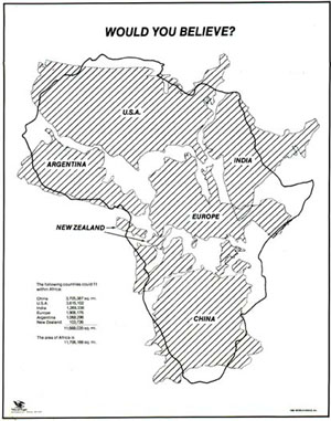
- Here's a map you have to see, would you believe how big is Africa? Mercator projections are messing with our perception of the world
Google Geonews: Introduction of Google Maps Engine Pro along with several Connectors, Google Glass News, and more
Here's the recent Google-related geonews.
From official sources:
-
The big news is certainly the Introduction of Google Maps Engine Pro: Helping businesses create, visualize and share their data on a map, from the announcement: "By importing data like addresses, names, office locations and sales leads from various file formats onto a map, businesses can edit, analyze and share their information in a simple format. Google Maps Engine Pro can be as easy to use as creating a document and it gives businesses an added productivity tool to help make decisions, organize information, and plan operations using Google Maps."
- You can ask for an introductory account to test it for your business. And GeoAwesomeness shares a short entry about it providing some complementary details.
- Google's Kurt led me to Google Maps Engine Connector for QGIS provided by Google themselves on GitHub, and there's the Google Maps Engine Connector for ArcGIS too, along with a Safe Software connector for FME announced for January
- DM also shares a related entry named What is the Google Maps Engine Public Data Program?
- Google+ Hangouts now supports location sharing, ie sharing your current location
- Google tells the story of an Indian boy lost in 1986 who used Google Earth to finally find is home town decades later
From other sources:
- Unsurprisingly, Drive With Google Glass: Get a Ticket
- More competition is good, Patent Filing Reveals Samsung's Designs For Google Glass Competitor
- What about Using Google Earth to teach math (targetting 5-10th grade students)
- Cube Cities have an entry on Rent Rolls in Google Earth
- The GEB reports there's New 3D Imagery in Detroit, Salt Lake City, and likely other cities and there was the usual New Google Earth Imagery on October 21
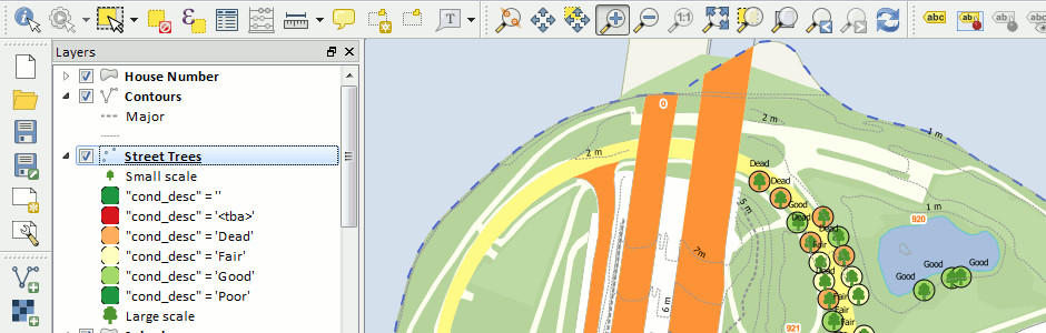
QGIS 2.0 Released
This is major news. The popular open source desktop GIS formerly known as Quantum GIS, now simply QGIS, has released its version 2.0 at FOSS4G. This release reduces the gap with some of the mature commercial desktop GIS available. There's also QGIS 2.0 for Android in the works.
Here's the full list of what's new and changed - it's just too long to copy it all, so here's some of it:
User interface:
- Feature: Side tabs, collapsable groups
- Feature: Soft notifications
- Feature: Drag and drop form builder
Data providers:
- Feature: Oracle Spatial support
- Feature: Web Coverage Service (WCS) provider added
- Feature: Raster 2% cumulative cut by default
- Feature: WMTS Support
Symbology:
- Feature: Data defined properties
- Feature: Support for transparency in colour definitions
- Feature: Color Control for Raster Layers
Map composer:
- Feature: Multipage support
- Feature: Layer blending
- Feature: Multicolumn composer legend
Labeling:
-
Feature: Expression based label properties
There's a lot more to it. Head to the full list to learn more and see numerous screenshots.